
Northeast Overview - September 2026
Monthly Summary
PLEASE NOTE: Data is preliminary and subject to change.
Summary Statement
September was warmer and wetter than normal for multiple parts of the Northeast, driven by locally heavy rainfall and an early-season nor’easter; however, cool temperatures and intensifying drought prevailed in a few areas like Maine.
Temperature
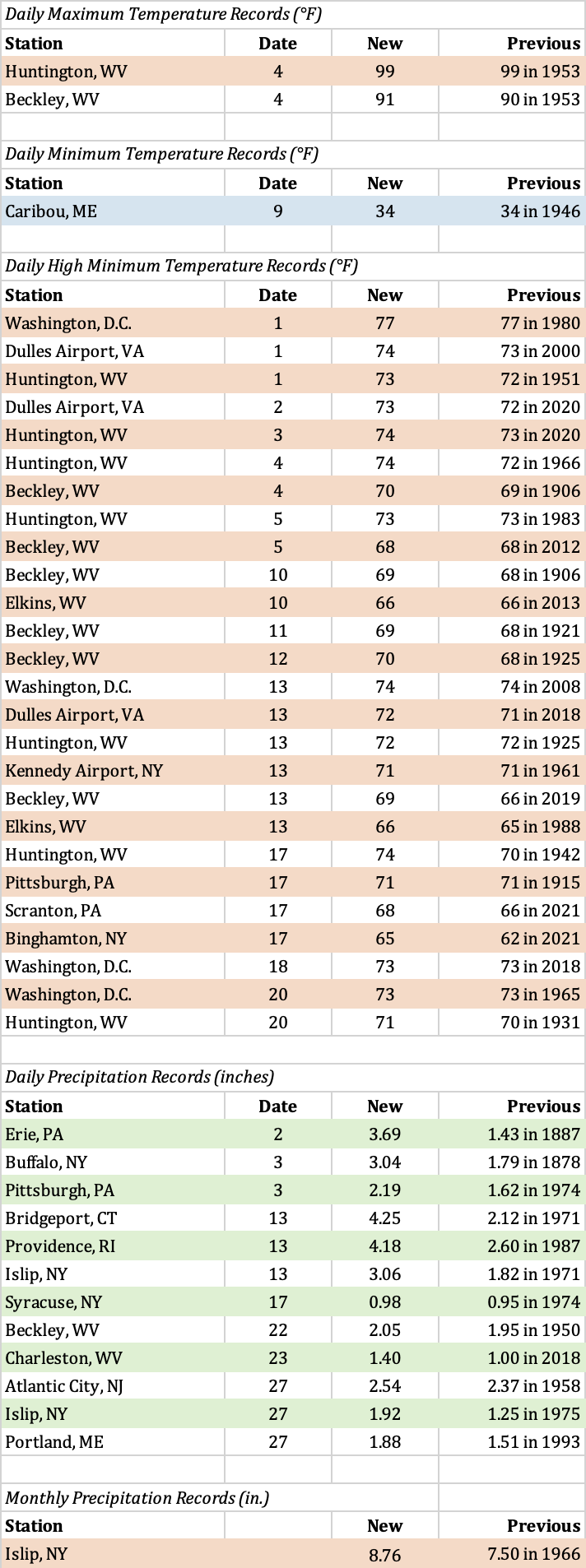
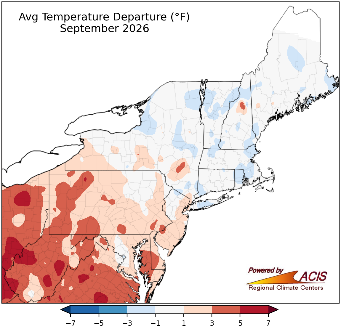
The Northeast’s average temperature for September was 62.7 degrees F, 1.0 degree F warmer than normal. September average temperature departures for the 12 Northeast states ranged from 0.6 degrees F below normal in New Hampshire to 3.7 degrees F above normal in West Virginia, with six of the states being warmer than normal. This September ranked among the 20 warmest Septembers on record for five states: West Virginia, eighth warmest; Delaware, Maryland, and New Jersey, 13th warmest; and Pennsylvania, 16th warmest. Huntington, West Virginia, had 12 days with a low of 70 degrees F or higher, a record for September. Meanwhile, Charleston, West Virginia, had six such days, tying its September record.
Precipitation
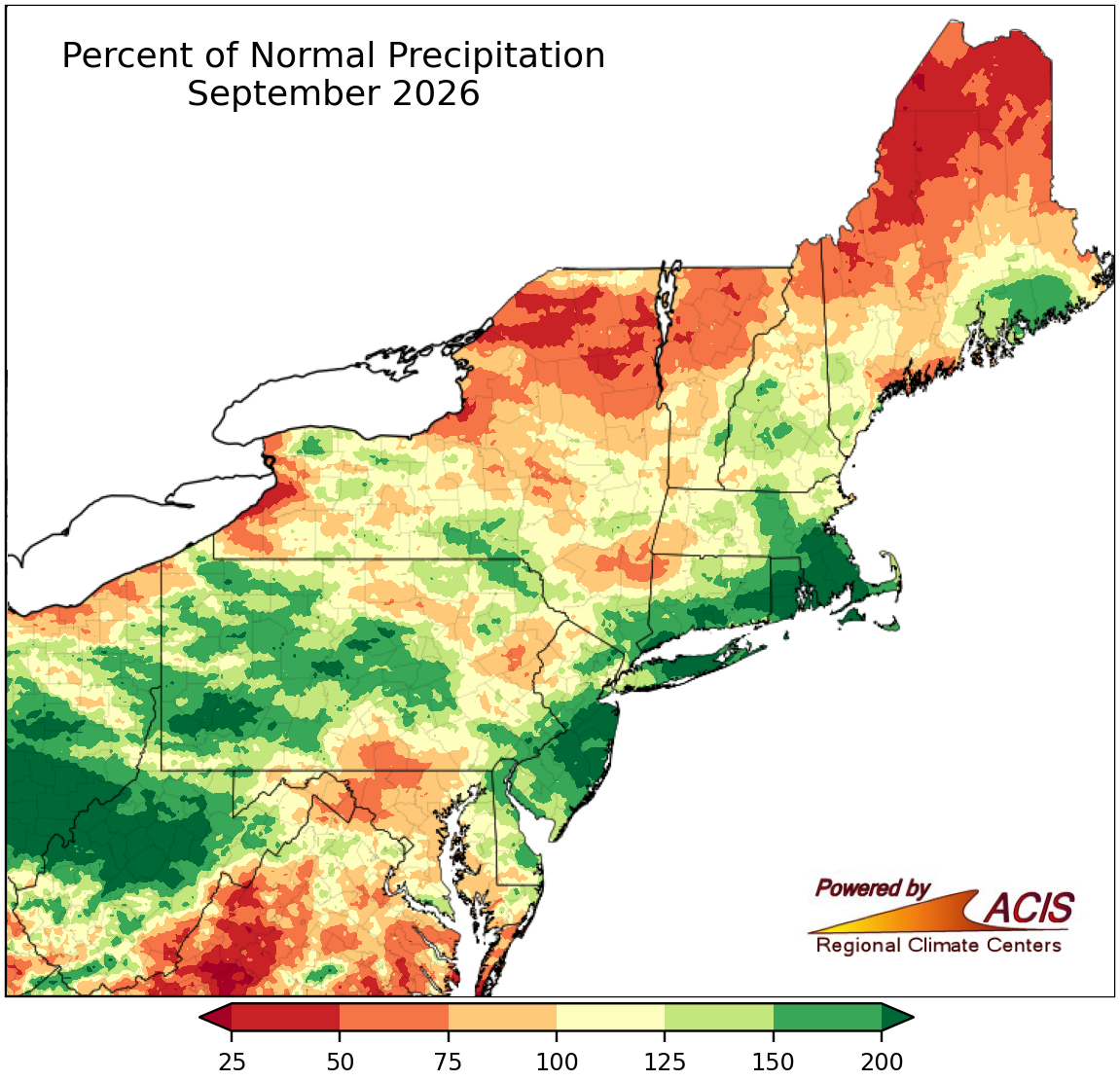
September precipitation in the Northeast totaled 4.28 inches, which was 106 percent of normal. For the 12 Northeast states, September precipitation ranged from 73 percent of normal in Maine to 186 percent of normal in Rhode Island, with eight states being wetter than normal. September 2026 ranked among the 20 wettest Septembers since recordkeeping began for four states: Rhode Island, sixth wettest; West Virginia, 16th wettest; New Jersey, 17th wettest; and Pennsylvania, 20th wettest. Islip, New York, had its wettest September on record with 8.76 inches of precipitation, beating its old record of 7.50 inches from 1966.
Drought
The U.S. Drought Monitor from September 1 showed 18 percent of the Northeast in drought and 25 percent of the region as abnormally dry. Portions of the Mid-Atlantic, southeastern New York, and southern New England saw plentiful precipitation during September, allowing conditions to improve. Severe drought was erased from these areas, while moderate drought and abnormal dryness shrank in coverage. New Jersey became free of drought for the first time since August 2025. Massachusetts, Maryland, and West Virginia reached their lowest coverage of drought since August or October 2025. However, conditions deteriorated in portions of northern New England and upstate New York due to factors like drier-than-normal weather and reduced streamflow, groundwater levels, and soil moisture. For example, in Maine, extreme drought was introduced and severe and moderate drought expanded, with the entire state in drought by mid-month. Moderate drought and/or abnormal dryness also expanded in New Hampshire, Vermont, and northern and western New York. The U.S. Drought Monitor from September 29 showed 21 percent of the Northeast in drought and 19 percent of the region as abnormally dry. Several drought-related impacts were reported in the region. USGS 7-day streamflow was below normal or lower in several areas at times during the month including central Maryland, east-central New Jersey, northern New York, and northern New England, with record-low levels mostly confined to Maine. Groundwater levels were record low at times during the month in several areas including southern Maryland, parts of New Jersey, southeastern Massachusetts, and southern Maine. There were several reports of dry wells in Maine, resulting in increased business for well-drilling companies. In early September, water levels at a reservoir in Baltimore County, Maryland, were 20 feet below average due to prolonged drought conditions, causing a boat launch to be closed. In late September, a news report noted that Willard Pond near Dover, New Hampshire, had dropped to its lowest level in 20 years, with two driven wells nearby shut down. Meanwhile, the main storage reservoir for Cambridge, Massachusetts, was at 20 percent of capacity in late September, leading to the possibility of the city buying water from the Massachusetts Water Resources Authority for the first time since the drought of 2016. Water conservation was encouraged in some areas, with several water suppliers in places like New Hampshire and Massachusetts having mandatory water restrictions or watering bans. Reports from Maine noted dry soils, stunted plants and slow hay growth, and reduced yields of crops like garlic, peppers, and pumpkins. Further, drought stress in trees in Maine led to premature leaf drop and had the potential to lead to a shorter foliage season, particularly in coastal areas that experienced more severe drought conditions.
Notable Weather Events
The first half of September featured several rounds of severe weather and/or flash flooding. There was a preliminary total of 12 tornadoes in the Northeast: eight in New York and four in Pennsylvania. Both states average one tornado during September (2001 to 2025 data). The second half of September featured a damaging, early-season nor’easter. A few events are highlighted below.
- September 1 to 4 – Severe thunderstorms affected the region each day. Eleven tornadoes touched down: three in northern/central Pennsylvania on September 1 and eight in western/central New York on September 2. Seneca County, New York, saw two tornadoes, its greatest number for any day, month, and year since records began in 1950. Montour County, Pennsylvania, had its first September tornado on record. Orleans County, New York, had only its second tornado on record, while Niagara County, New York, saw its first tornado in over 20 years. There were also multiple instances of straight-line wind damage across the Northeast. For instance, straight-line winds of up to 90 mph caused damage along a path from southeastern Pennsylvania through northern Delaware into southwestern New Jersey. Damage from the tornadoes and non-tornadic winds included downed trees, snapped power poles, flattened fields, and damage to roofs, siding, and windows on homes and farm buildings. Localized flash flooding in parts of western New York and western and central Pennsylvania led to water rescues, evacuations, and flooded basements. For example, in Pennsylvania, 24 people were evacuated in a small community in Lycoming County, and 10 people were rescued from an apartment building after being trapped by floodwaters in Westmoreland County. There were at least four people injured due to the storms. Temperatures were also unusually warm in portions of the Mid-Atlantic during this period, with low temperatures ranking among the 10 warmest for September at several sites. For instance, Huntington, West Virginia, had low temperatures on three of the four days that ranked among their 10 warmest for the month.
- September 12 to 13 – Portions of the Mid-Atlantic, southeastern New York, and southern New England saw significant rainfall that contributed to flash flooding. For example, the greatest rainfall totals in several counties near New York City in northeastern New Jersey, southeastern New York, and southern Connecticut ranged from 3 to 8 inches. September 13 was the second-wettest September day for Islip, New York, with 3.06 inches of rain, the fourth-wettest September day for Bridgeport, Connecticut, with 4.25 inches, and the fifth-wettest September day for Providence, Rhode Island, with 4.18 inches. Storm reports noted that homes and businesses were flooded, cars and buses were trapped in floodwaters, roads were inundated, and there were numerous water rescues.
- September 25 to 28 – An early-season nor’easter brought strong winds, high water levels, and heavy rain to coastal areas of the Northeast. Maximum wind gusts of 40 to 60 mph were common, with locally higher gusts of up to 80 mph. Water levels reached moderate to major flood levels during several consecutive tide cycles. Some gauges along the Mid-Atlantic coastline recorded their highest water levels in 10 to 15 years (since the blizzard of January 2016 or Hurricane Sandy in October 2012), ranking among the 10 highest water levels on record for a few sites. There was extensive erosion of beaches and dunes, particularly along the New Jersey coastline. The highest rain totals ranged from 5 to 7 inches in portions of New Jersey, southeastern New York, and southern New England. There was coastal flooding and localized flash flooding, with floodwaters submerging roads, entering buildings, and inundating vehicles. Storm reports also noted downed trees and power lines, resulting in power outages. There was at least one fatality and six injuries related to the storm.
Relevant Links (click to view)
Monthly Records