Middle of January and Winter
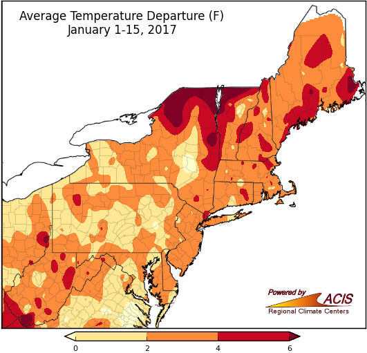
January 1-15 was warmer than normal in the Northeast.
During the first half of January, average temperatures ranged from near normal to more than 6°F above normal. The warmest areas were in northern New York, northern Vermont, and southern West Virginia. All 35 major climate sites experienced above-normal temperatures, with five ranking it among their top 20 warmest starts to January.
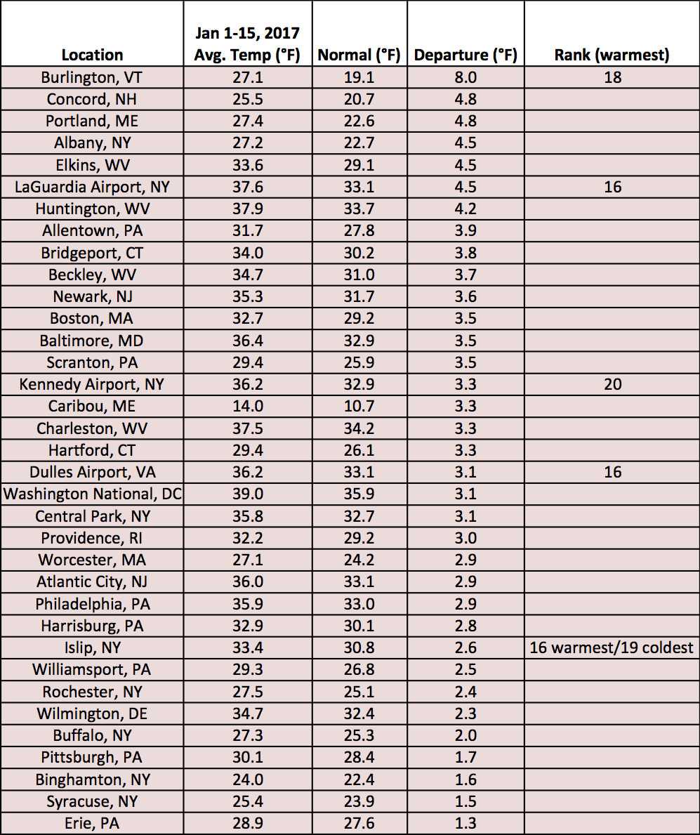
Mid-January average temperatures for the major climate sites ranged from 1.3°F above normal in Erie, Pa to 8.0°F above normal in Burlington, VT.
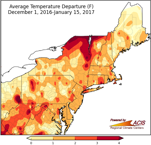
The first half of winter was also warmer than normal for most of the Northeast.
From December 1, 2016 through January 15, 2017, average temperatures ranged from 1°F below normal to more than 4°F above normal. The coolest spots were in portions of Maine, while the warmest spots were in northern New York and northwestern Vermont. Thirty-four major climate sites had above-normal average temperatures, with six ranking it among their top 20 warmest starts to winter.
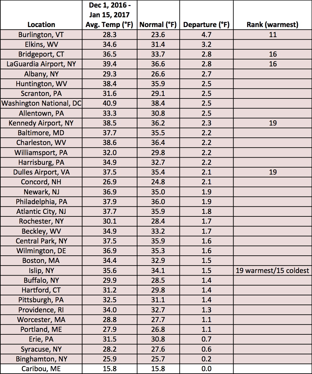
Mid-winter average temperatures at the major climate sites ranged from normal in Caribou, ME to 4.7°F above normal in Burlington, VT.
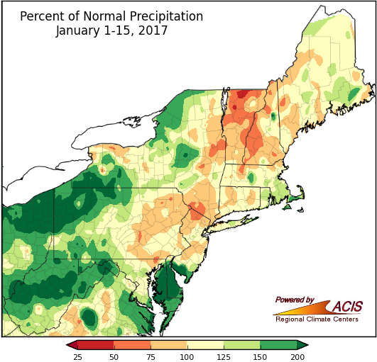
January 1-15 precipitation was variable in the region.
Precipitation during the first half of January ranged from less than 75% of normal to more than 200% of normal. Portions of northern Vermont and western New Hampshire were generally the driest areas, while portions of southwestern New York, northwestern Pennsylvania, central West Virginia, eastern Maryland, and Delaware were generally the wettest areas. Twenty-six of the 35 major climate sites were wetter than normal, with five ranking it among their top 20 wettest starts to January.
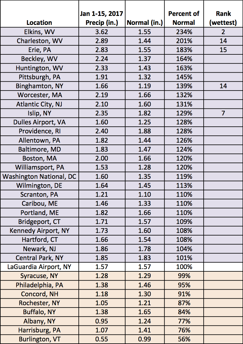
Mid-January precipitation at the major climate sites ranged from 56% of normal in Burlington, VT to 234% of normal in Elkins, WV.
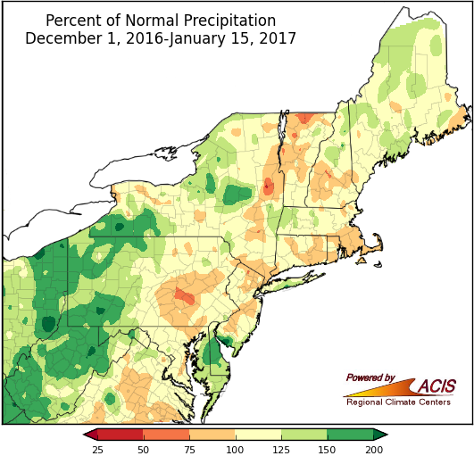
Precipitation was also variable during the first half of winter.
From December 1, 2016 through January 15, 2017, precipitation ranged 75% to 200% of normal for most of the Northeast. The driest areas and wettest areas were scattered throughout the region. Eighteen of the major climate sites were drier than normal while fourteen were wetter than normal. Four sites ranked the first half of this winter among their top 20 wettest. Due to Islip, NY’s short period of record, it ranked among both the wettest and driest starts to winter there.
Drought conditions lingered in the region. The Northeast Regional Climate Center’s weekly drought update can be found here: http://www.nrcc.cornell.edu/regional/drought/drought.html.
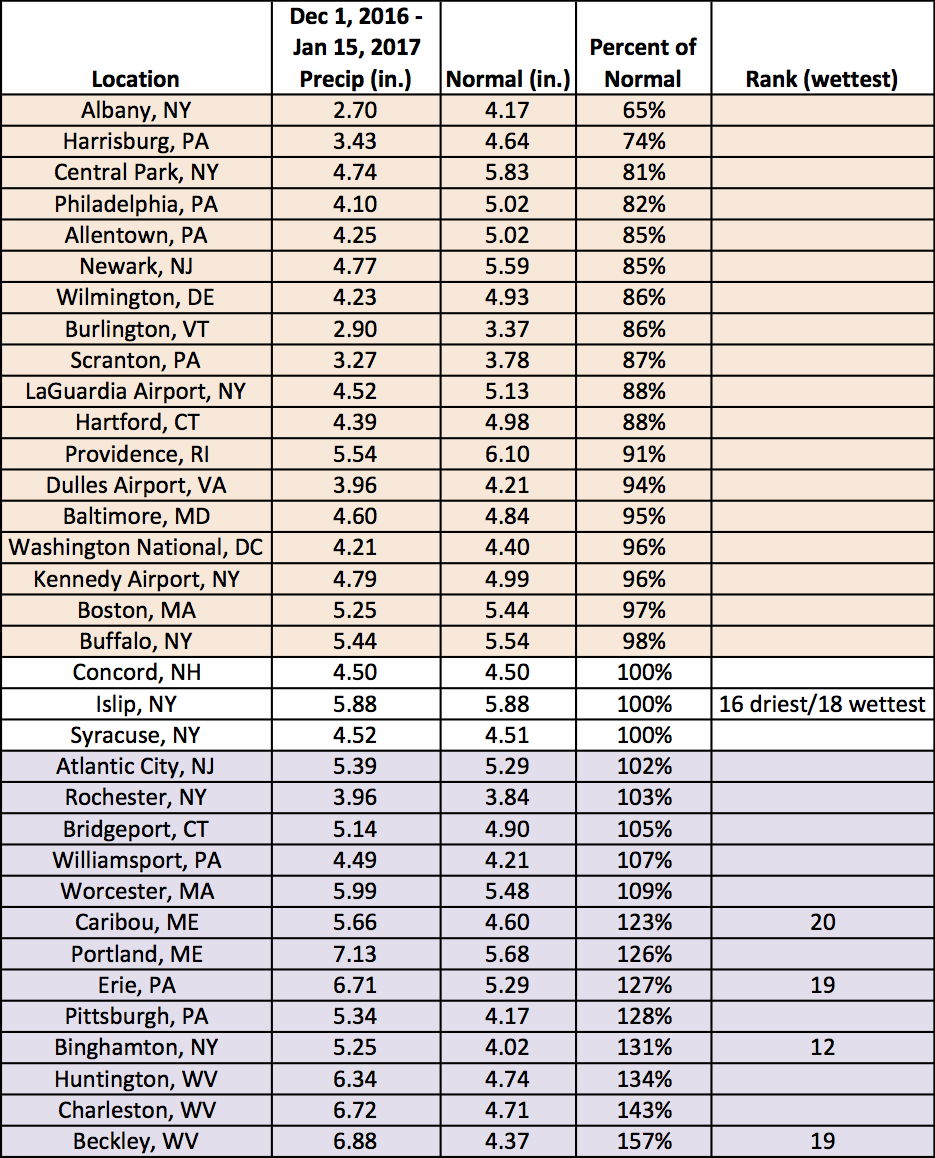
Mid-winter precipitation at the major climate sites ranged from 65% of normal in Albany, NY to 157% of normal in Beckley, WV.
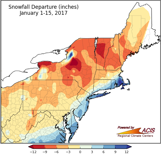
January 1-15 snowfall was variable in the region.
Snowfall during the first half of January ranged from more than 12 inches below normal in portions of central New York to more than 12 inches above normal in southeastern Massachusetts and near the eastern end of Lake Ontario in New York. Twenty-three of the 35 major climate sites have seen below-normal snowfall, with five ranking it among their top 20 least snowy starts to January. Conversely, of the twelve snowier-than-normal sites, nine ranked it among their top 20 snowiest starts to January.
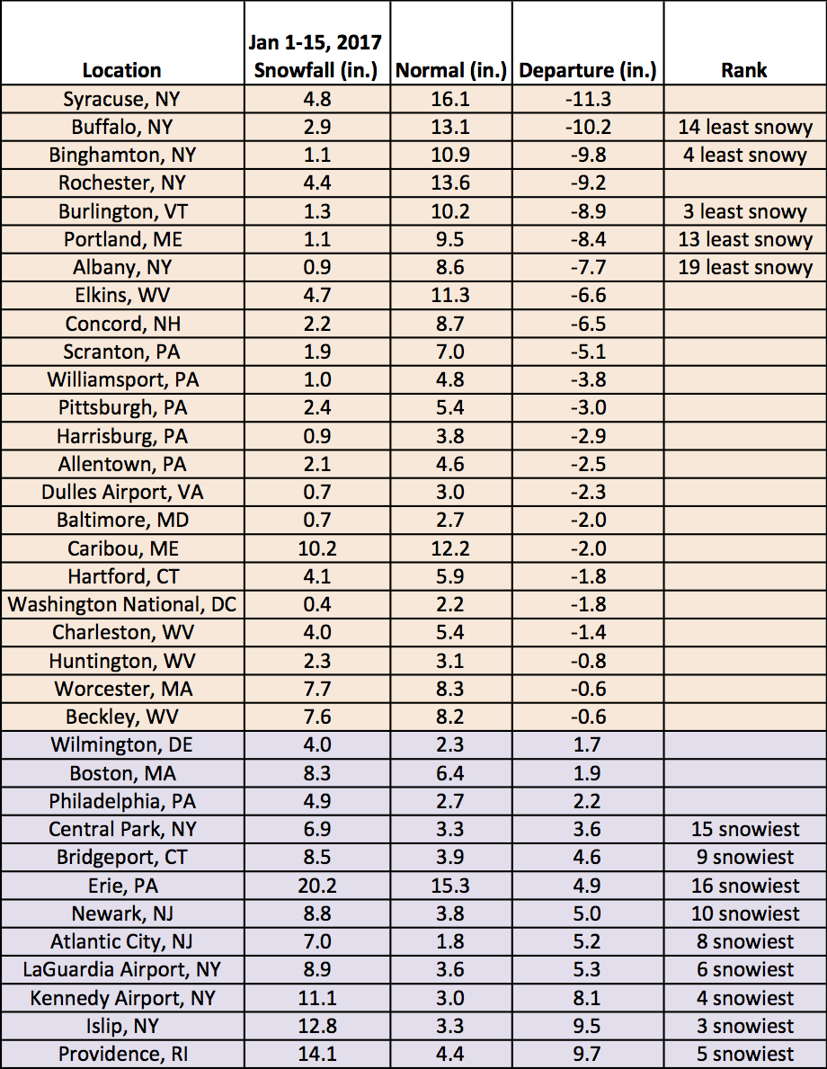
Mid-January snowfall at the major climate sites ranged from 11.3 inches below normal in Syracuse, NY to 9.7 inches above normal in Providence, RI.
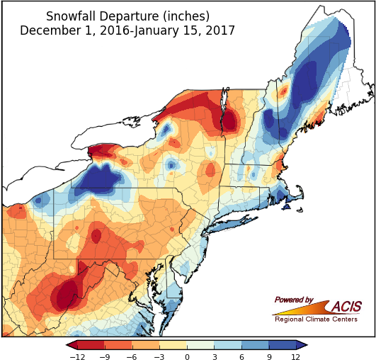
Snowfall was also variable during the first half of winter.
From December 1, 2016 through January 15, 2017, snowfall ranged from more than 12 inches below normal in western Vermont and West Virginia to more than 12 inches above normal in southwestern New York and central New Hampshire, and central Maine. Twenty-two of the major climate sites received below-normal snowfall, with three ranking it among their top 20 least snowy starts to winter. Of the thirteen snowier-than-normal sites, five ranked it among their top 20 snowiest starts to winter.
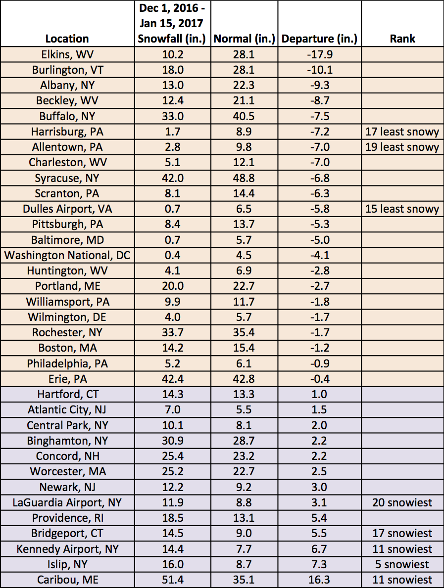
Mid-winter snowfall ranged from 17.9 inches below normal in Elkins, WV to 16.3 inches above normal in Caribou, ME.