June Wraps Up
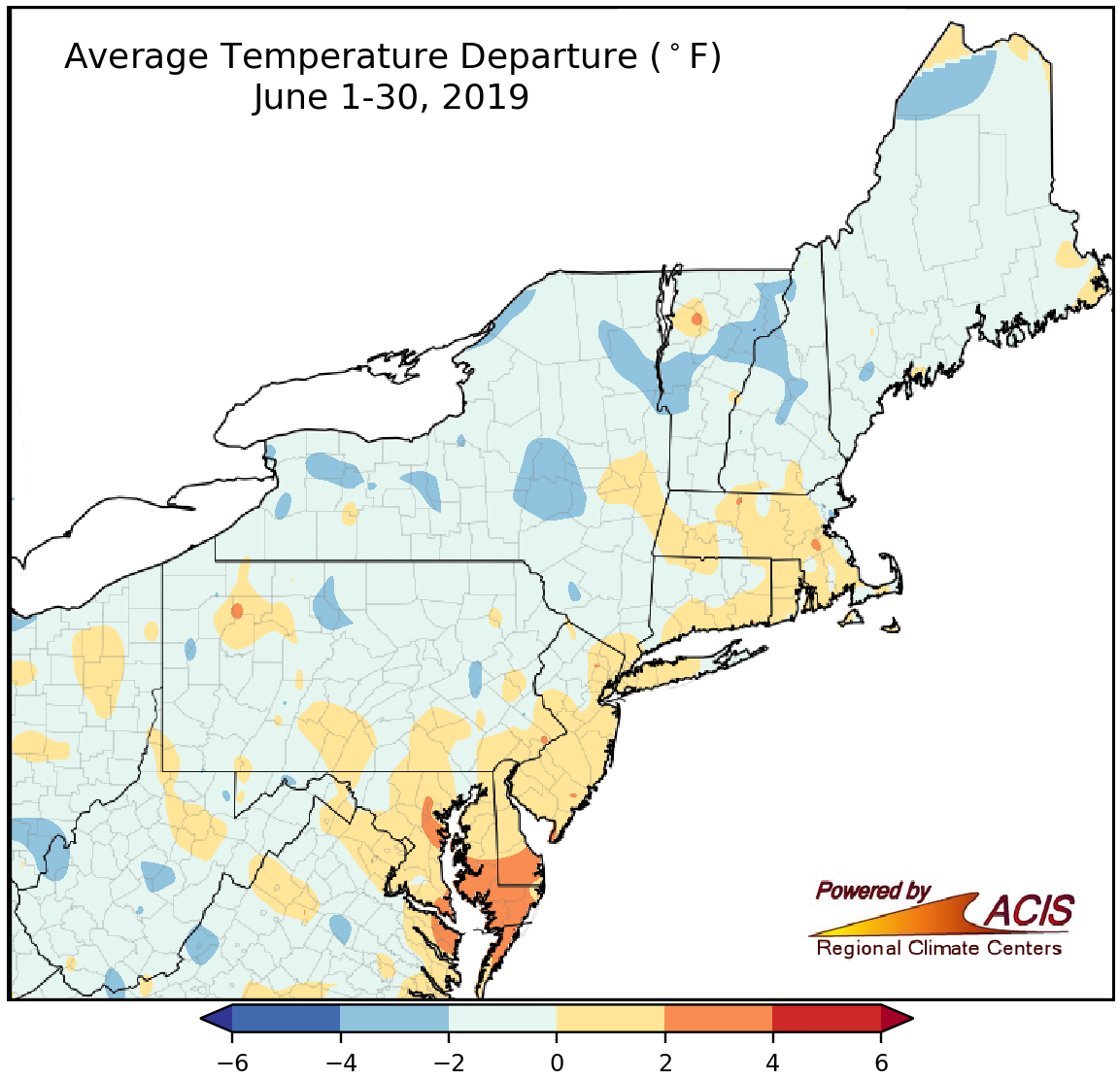
June average temperatures ranged from 4°F below normal to 4°F above normal.
June averaged out to be within 2°F of normal for a large portion of the Northeast. However, there were a few colder spots, particularly in parts of West Virginia, New York, and northern New England, that were as much as 4°F below normal and a few warmer spots, mainly in Maryland and Delaware, that were up to 4°F above normal. Five of the 22 major climate sites that were warmer than normal ranked this June among their 20 warmest on record.
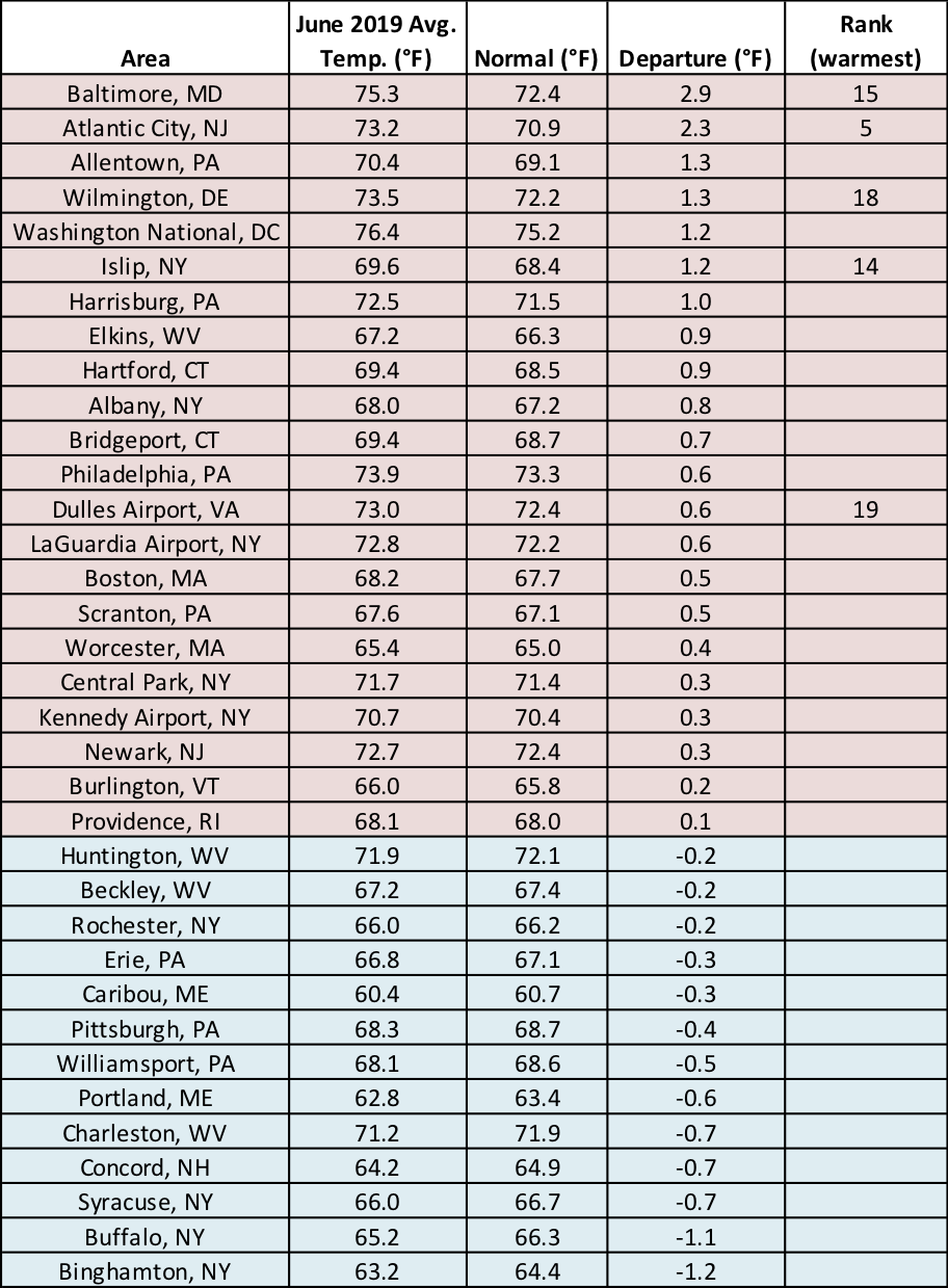
June average temperatures at the major climate sites ranged from 1.2°F below normal in Binghamton, NY, to 2.9°F above normal in Baltimore, MD.
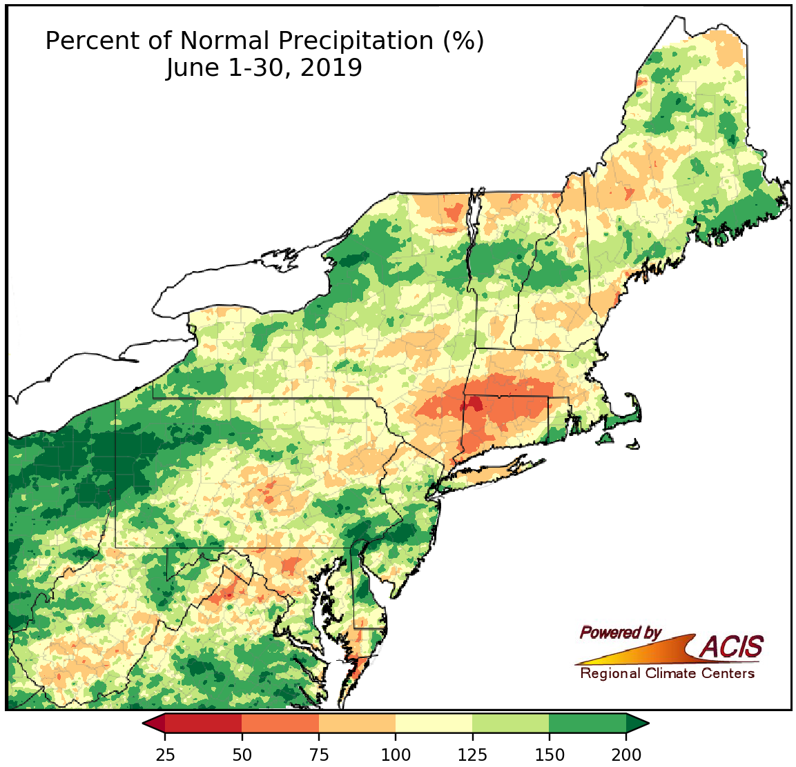
June precipitation generally ranged from 50% of normal to more than 200% of normal.
There were a few drier-than-normal areas, especially in Massachusetts, Connecticut, and southeastern New York, that received less than 75% of normal June precipitation. However, much of the Northeast wrapped up June with near to above-normal precipitation. The wettest areas, which were generally in Pennsylvania, New Jersey, and Delaware, saw more than 200% of normal precipitation. Of the 35 major climate sites, 26 were wetter than normal, with 11 of those ranking this June among their 20 wettest. On the other hand, Dulles Airport, VA, and Beckley, WV, each had their 19th driest June on record.
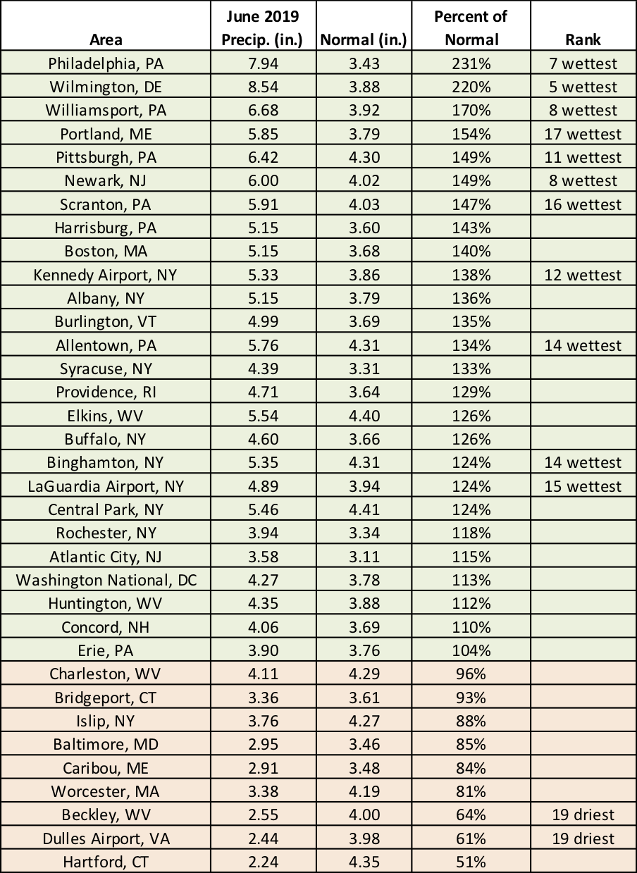
June precipitation at the major climate sites ranged from 51% of normal in Hartford, CT, to 231% of normal in Philadelphia, PA.
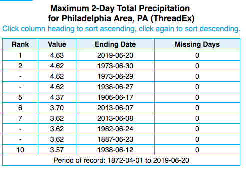
Philadelphia, PA, had its wettest two-day period for the month of June.
There were several instances of flash flooding during the month. From June 18 to 21, parts of New Jersey, Pennsylvania, and New York received as much as 3 to 7 inches of rain. In fact, Philadelphia, PA, had its greatest two-day rainfall total for the month from June 19 to 20 with 4.63 inches. Around 4 inches of that, more than the site averages during all of June, fell within a three-hour period. Flash flooding ensued, with preliminary data indicating the North Branch Rancocas Creek at Pemberton, NJ, had its second highest crest on record. As water submerged roads and entered homes, there were evacuations and water rescues.
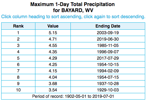
Bayard, WV, had its second wettest day on record.
Another significant flash flooding event happened from June 29 to 30 in western Maryland and eastern West Virginia when some areas received up to 5 inches of rain in just a few hours. Bayard, WV, recorded 4.71 inches of rain between 7AM on June 29 and 7AM on June 30, making it their second wettest day on record. The Baltimore-Washington National Weather Service (NWS) issued a rare Flash Flood Emergency for Bayard. A few miles downstream, preliminary data showed the North Branch of the Potomac River at Steyer, WV, rose nearly 8 feet in two hours. Storm reports from West Virginia indicated there were evacuations and water rescues, some homes were pushed from their foundations, and roads were closed due to high water, mudslides, or damage.
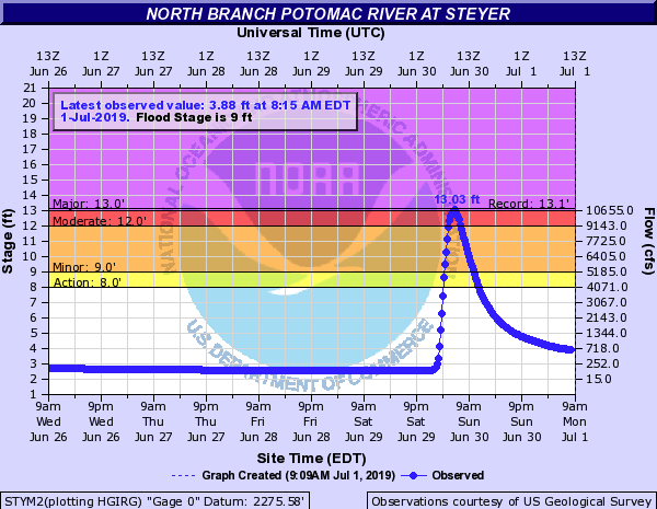
The North Branch of the Potomac River rose rapidly (blue line) in response to heavy rain. Image courtesy of NOAA/National Weather Service.
The Northeast averages 10 tornadoes in June (based on 1989-2013 data), making it the second most active month behind July. However, the region saw only seven tornadoes this June: three in Pennsylvania, two in New Jersey, and one each in Maryland and West Virginia. Tornado activity was below or near normal for each state except New Jersey. Preliminary data indicates Pennsylvania’s year-to-date tornado count is 34, making it one of the most active years for tornadoes. The greatest annual count was in 1998 with 59 tornadoes.
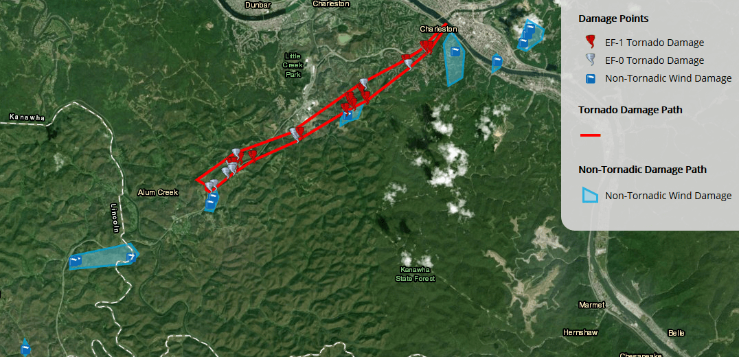
On June 24, a weak tornado produced (discontinuous) damage along an 8-mile path near Charleston, WV. Image courtesy NWS Charleston. Click to enlarge.
As for July, NOAA’s Climate Prediction Center favors an increased chance of below-normal temperatures for northwestern Pennsylvania and portions of New York, while an increased chance of above-normal temperatures is favored for southern West Virginia and much of Maryland and Delaware. Equal chances of below-, near-, or above-normal temperatures were predicted for the rest of the region. The entire region falls into the equal chances category for July precipitation.
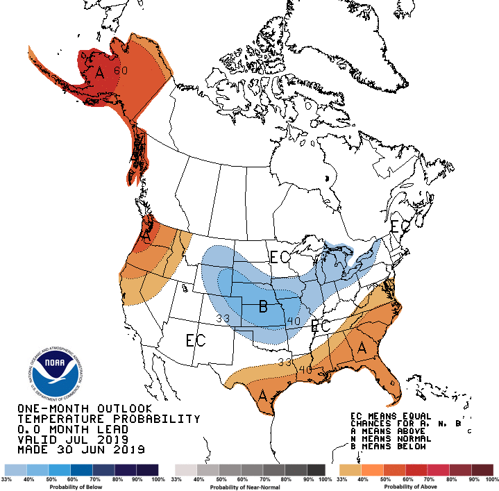
Below-normal July temperatures are favored in areas shaded blue, while above-normal temperatures are favored in areas shaded orange.