Wet and Mild Start to the Month
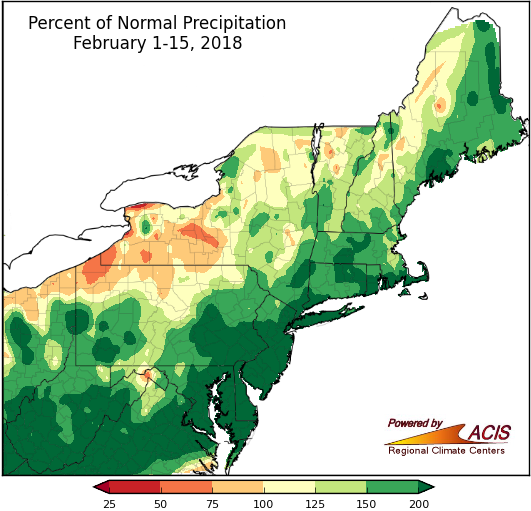
February has been a wet month so far, with several areas seeing more than double their normal February 1-15 precipitation (areas shaded dark green).
The first half of February has brought above-normal amounts of precipitation to much of the Northeast. During the February 1-15 timeframe, two of the 35 major climate sites, Atlantic City, NJ, and Beckley, WV, have recorded more precipitation throughout the beginning part of February this year than during this time period in previous years. Other than Burlington, VT, each climate site has had anywhere from 106% up to 339% of their normal precipitation. Although the early February snowstorm that brought accumulating snow to the interior Northeast contributed to these higher percentages, most of the locations that received over 200% of normal precipitation were in an area ranging from Massachusetts to Maryland and West Virginia. The above-normal precipitation helped ease drought and abnormally dry conditions in much of the region.
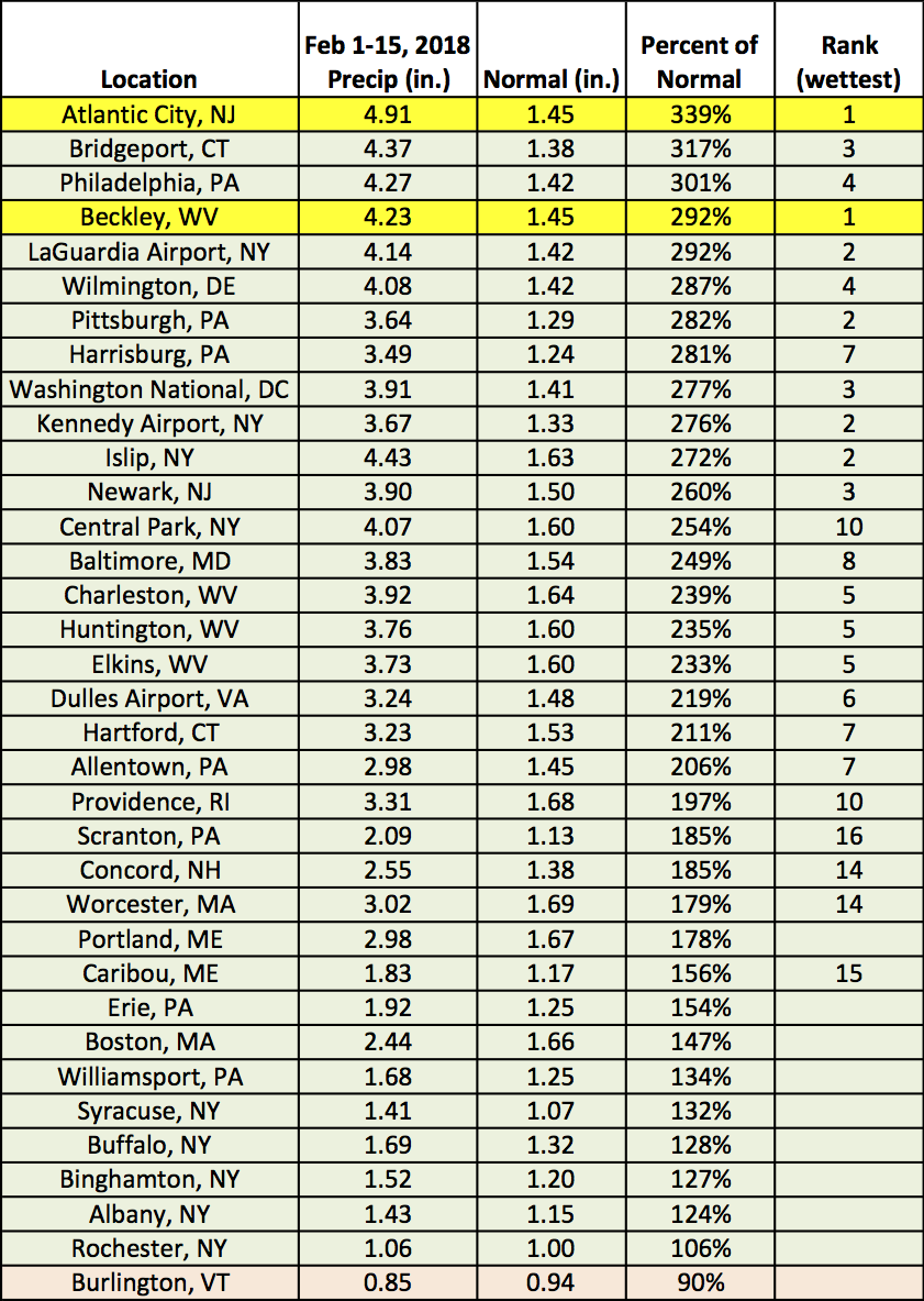
Atlantic City, NJ, and Beckley, WV, had a record wet start to February, while another 23 sites ranked this first half of February among their 20 wettest.
So far in February, temperatures have been on the mild side for many parts of the Northeast, especially in coastal areas from New England to Maryland, as well as in parts of West Virginia and Vermont. For instance, Burlington, VT, has trended 4.7˚F above normal, which ranks as the area’s 16th warmest start to the month. Places farther west that experienced colder than normal temperatures included locations closest to the Great Lakes, especially near Erie, PA, and Buffalo, NY.
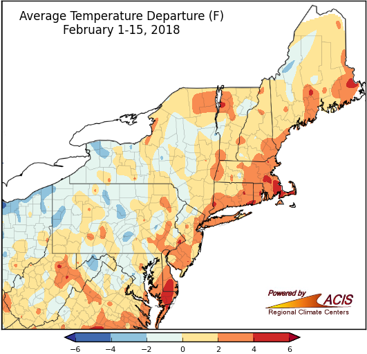
February 1-15 average temperatures ranged from 4°F below normal to 6°F above normal.
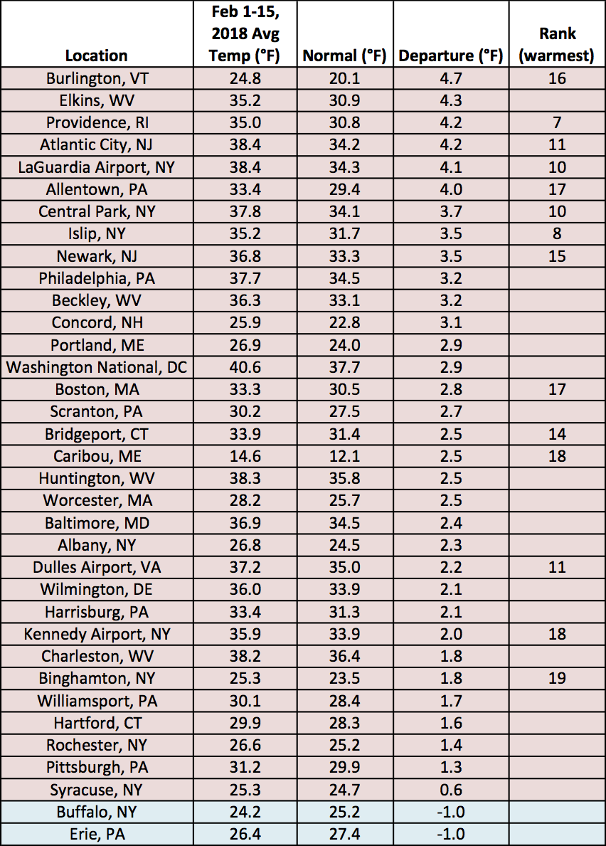
Fourteen major climate sites ranked this first half of February among their 20 warmest on record.
Snowfall totals have varied during this time period. Philadelphia, PA has received just 0.2 inches of snow, placing it five inches below average for this half of the month. Only a trace of snow has fallen in Washington, DC, and Atlantic City, NJ, with those regions seeing some of the least snowy starts to February on record. But, a few of the northern climate sites have a different story. Caribou, ME, has already received more than 21 inches of snow this month, making it the eighth snowiest start to the month on record.
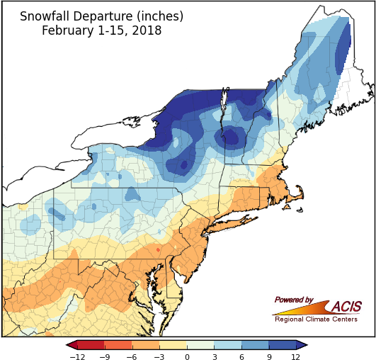
February 1-15 snowfall ranged from 6 inches below normal in an area from West Virginia to Massachusetts to more than 12 inches above normal in parts of New York and Vermont.

This first half of February ranked among the 20 least snowy at nine major climate sites and among the 20 snowiest at three sites.