July 4th Fun Facts
July 4th is fast approaching! Here’s a look at past conditions on Independence Day at the 35 major climate sites based on each site’s period of record, as well as some interesting weather events.
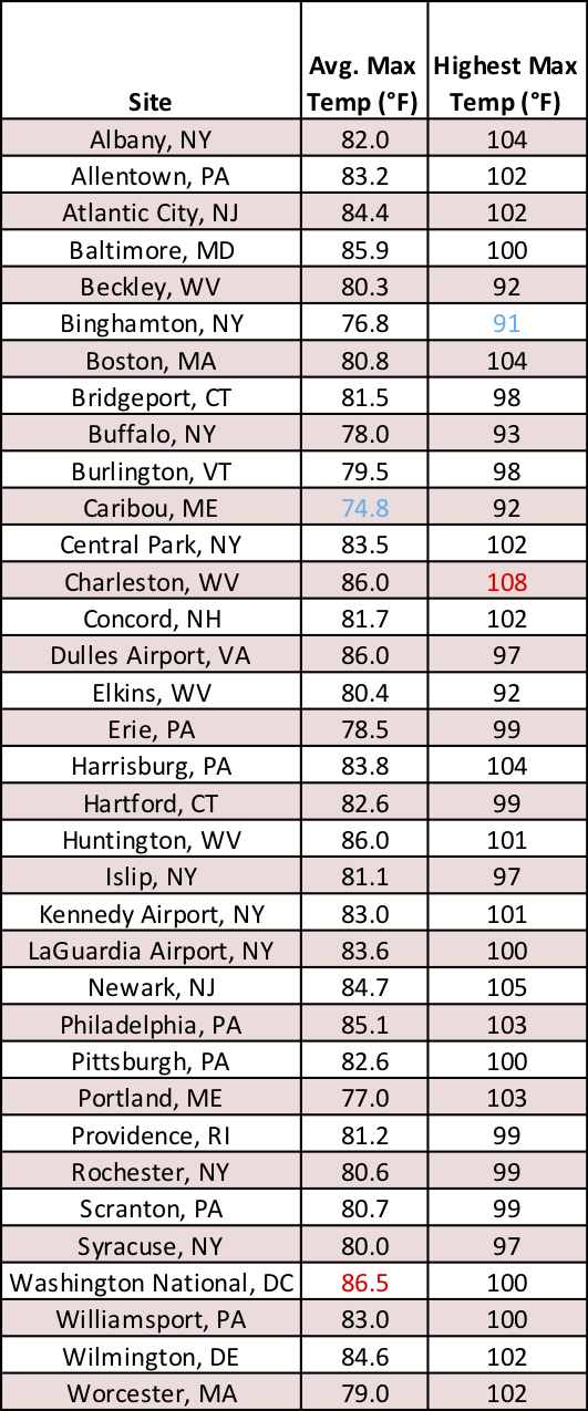
Average max temperature and highest max temperature on July 4.
The Baltimore-Washington metro area and southwestern West Virginia are the hottest places on July 4th with average max temperatures ranging from 85.9°F to 86.5°F. These areas also have the greatest likelihood of seeing highs reach 90°F or above, which has happened in roughly a third of all years. While Charleston, WV, boasts the hottest July 4th with a high of 108°F in 1931, a total of 20 major climate sites have seen the mercury soar to 100°F or higher on Independence Day.
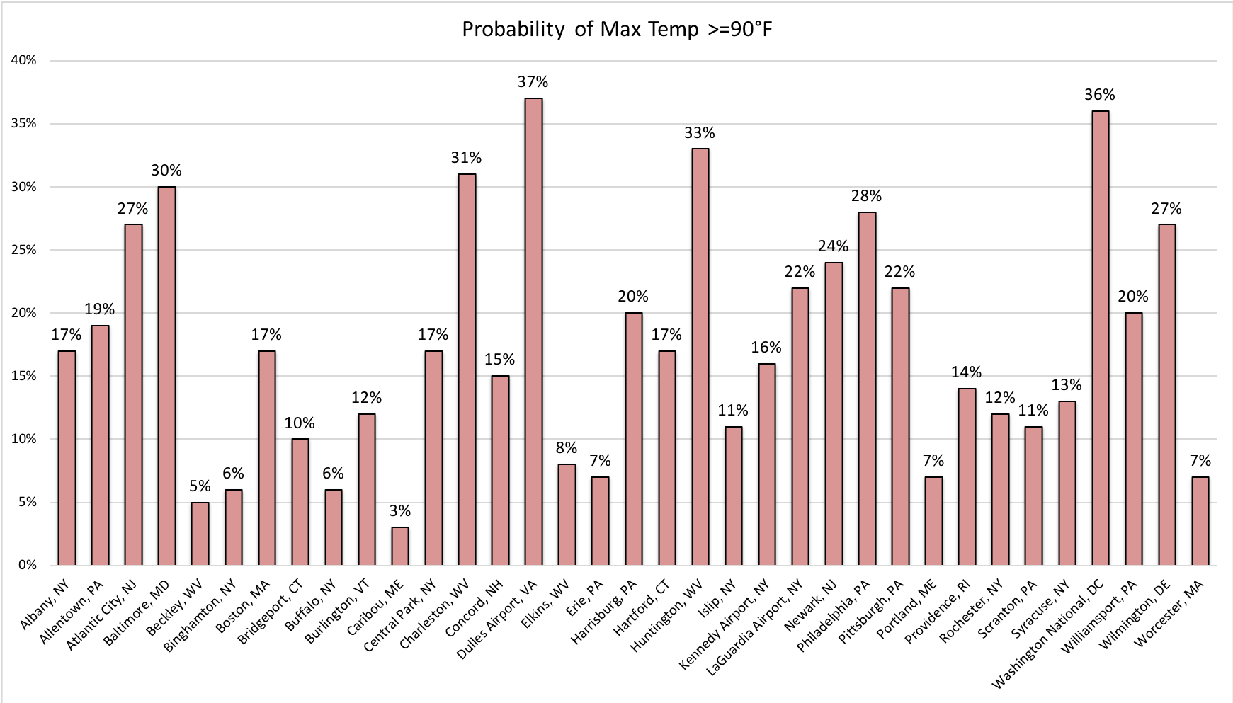
The probability of highs reaching 90°F or greater on July 4. Click to enlarge.
Caribou, ME, is home to the coldest July 4th temperature, 39°F in 1982; the lowest average min temperature, 53.7°F; and the lowest average max temperature, 74.8°F. This city in “The Crown of Maine” also has the lowest chance, 3%, of reaching 90°F or higher on Independence Day. It’s in good company, as a total of eight major climate sites have less than a 10% chance of hitting at least 90°F.
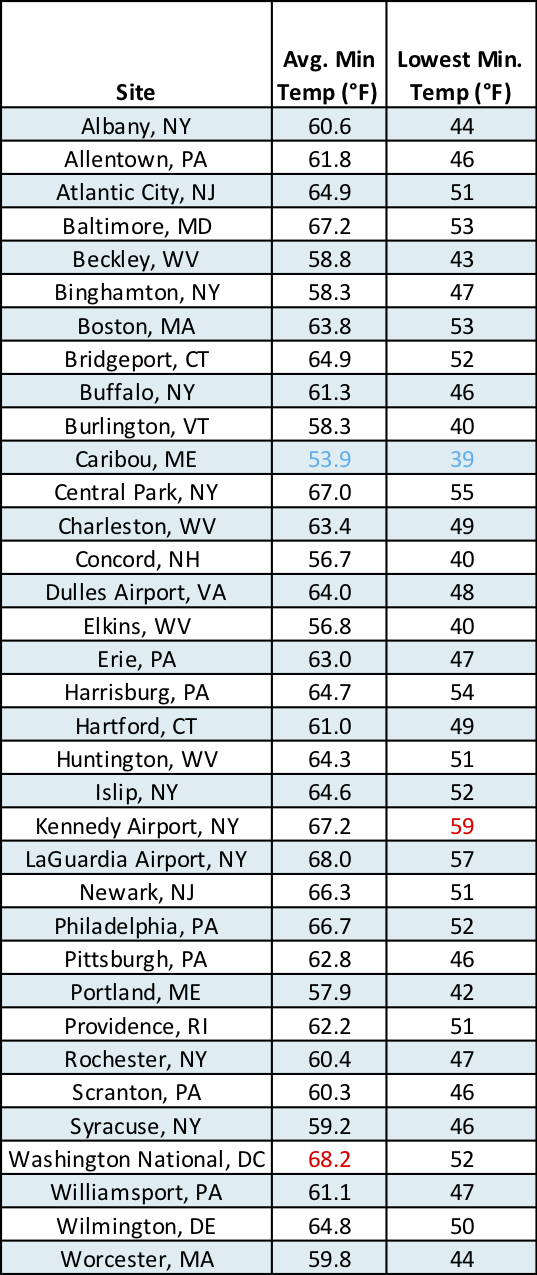
Average min temperature and lowest min temperature on July 4.
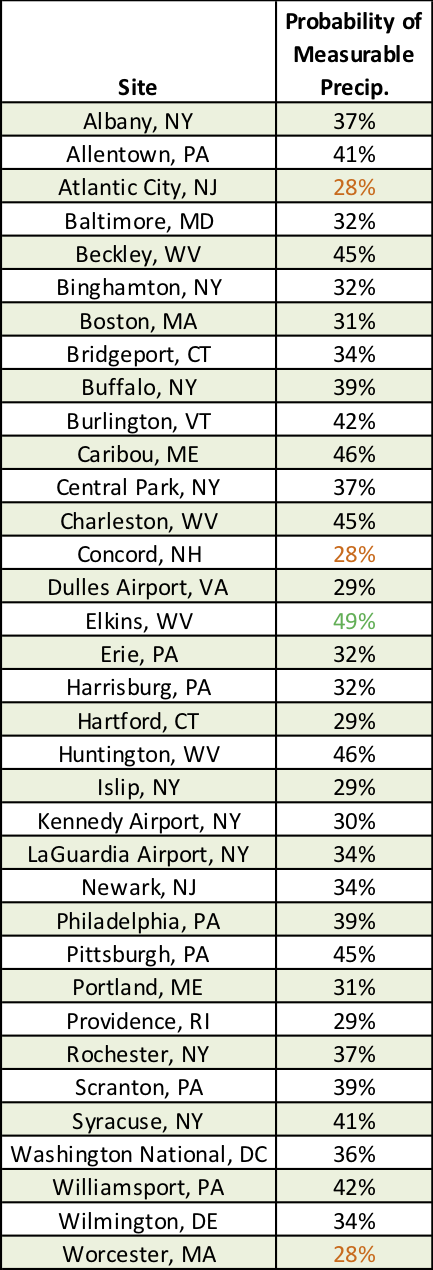
The probability of measurable precipitation (0.01 inches) on July 4.
The soggiest celebrations have occurred at Kennedy Airport, NY, and Huntington, WV, as each of these sites has received around 3 inches of rain on Independence Day. In fact, all four Mountain State (West Virginia) major climate sites have at least a 45% chance of measurable rain (0.01 inches) on July 4th, with Elkins having the greatest at 49%. On the other hand, seven major climate sites have less than a 30% chance of seeing rain on the Fourth of July, with the lowest likelihood, 28%, in Atlantic City, NJ; Concord, NH; and Worcester, MA.
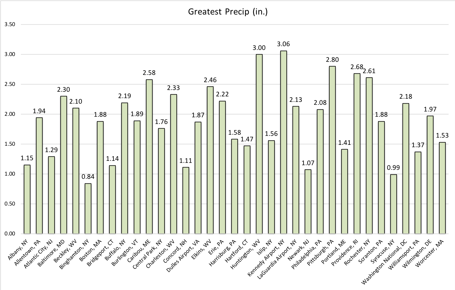
The greatest rainfall for each site on July 4. Click to enlarge.
Since 1950, there have been 10 tornadoes in the Northeast on July 4th: three each in West Virginia and Pennsylvania and one each in Maryland, Massachusetts, Vermont and Maine. The strongest of those tornadoes were rated EF-2, and the most recent occurred in 2016.
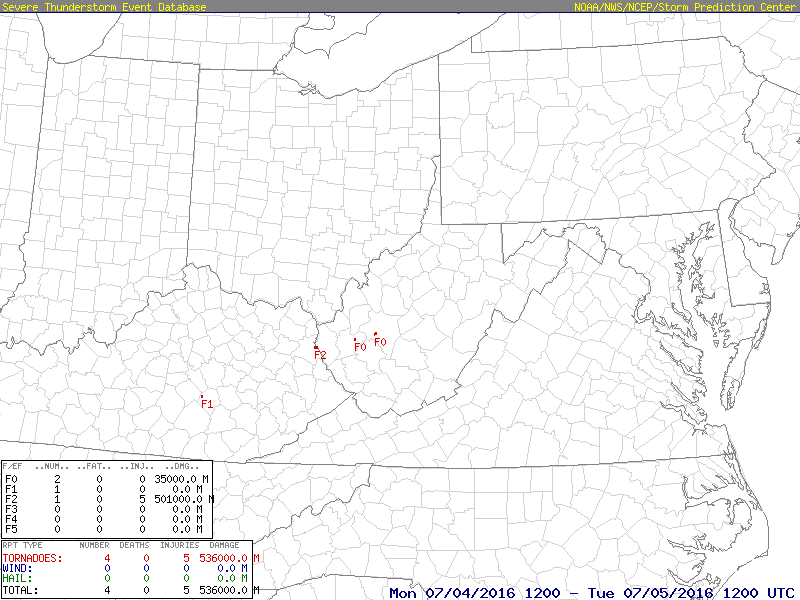
Three tornadoes moved through West Virginia on July 4, 2016. Click to enlarge.
Over the July 4th holiday in 2014, Hurricane Arthur dumped heavy rain on New England, with the highest amounts of 5 to 8 inches in southeastern Massachusetts and eastern Maine. Flash flooding made roads impassable, and wind gusts of over 60 mph brought down trees and caused power outages. In addition, some fireworks shows and holiday events were postponed or cancelled.
Hurricane Arthur’s track and rain totals. Image courtesy of NOAA.
A heat wave impacted the Northeast at the beginning of July 2018. From July 1 to 4, high humidity along with unusually warm temperatures resulted in heat indices over 110°F in some areas, prompting Excessive Heat Warnings to be issued by the National Weather Service. Daily high temperature records were set at numerous locations throughout New York, Vermont, and Maine. In fact, Buffalo, NY, had its hottest July 4th on record with a high of 93°F.
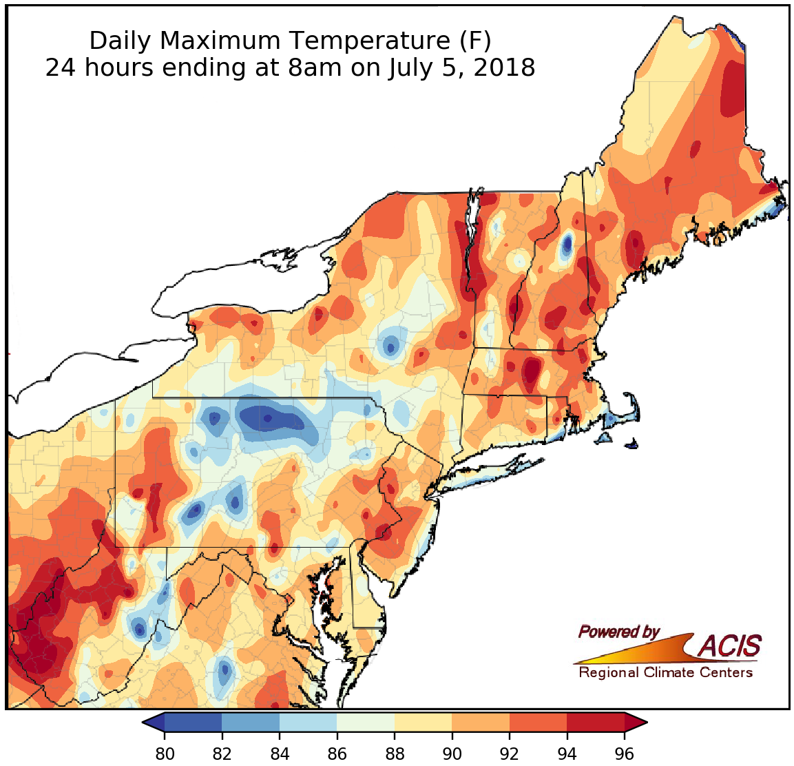
Max temperatures approached or exceeded 90°F in many areas on July 4, 2018.