A Frigid End to a Warm Year
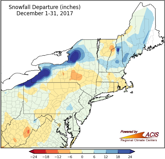
December snowfall for much of the region was within 6 inches of normal, with portions of northwestern Pennsylvania, western and northern New York, and northern New England receiving more.
December snowfall ranged from 12 inches below normal in parts of eastern West Virginia, central New York, and northeastern Vermont to more than 24 inches above normal in lake-effect prone areas east of Lakes Erie and Ontario. Much of the region, though, saw snowfall amounts that were within 6 inches of normal. Twenty-four of the region’s 35 major climate sites were snowier than normal, with 14 sites ranking this December among their 20 snowiest. Conversely, Binghamton, NY, had its 17th least snowy December.
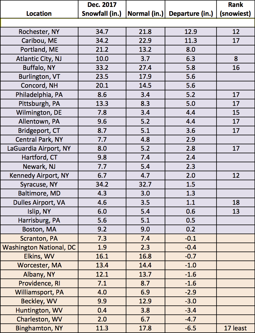
December snowfall ranged from 6.5 inches below normal in Binghamton, NY, to 12.9 inches above normal in Rochester, NY.
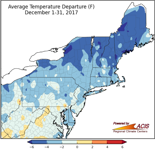
December average temperatures ranged from 6°F below normal to normal for most areas.
December average temperatures ranged from more than 6°F below normal to 2°F above normal, with temperatures for most areas from 6°F below normal to normal. The coldest spots were in northern New England and northern New York, while the warmest spots were generally in West Virginia and Maryland. All but one of the 35 major climate sites were colder than normal, with four sites ranking the month among their 20 coldest Decembers.
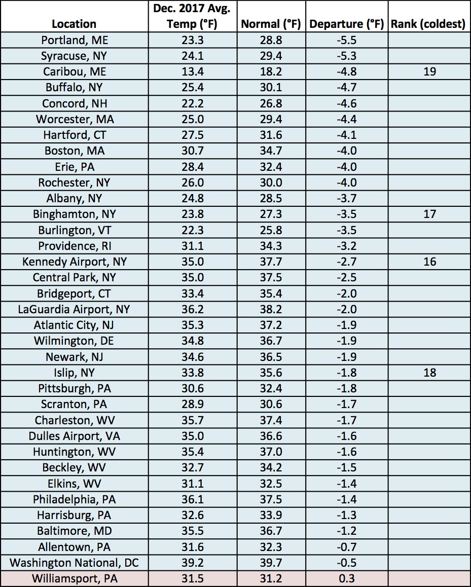
December average temperatures at the major climate sites ranged from 5.5°F below normal in Portland, ME, to 0.3°F above normal in Williamsport, PA.
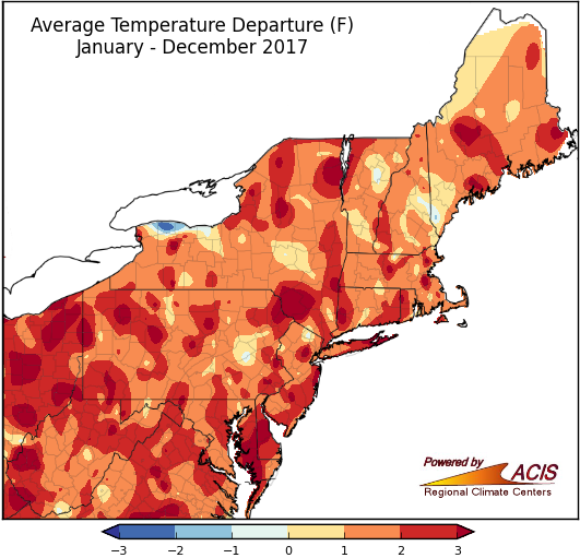
2017 was another warmer-than-normal year for the Northeast.
Average temperatures for 2017 ranged from normal to more than 3°F above normal for a majority of the region. All 35 major climate sites were warmer than normal, with 34 sites ranking 2017 among their 20 warmest years on record.
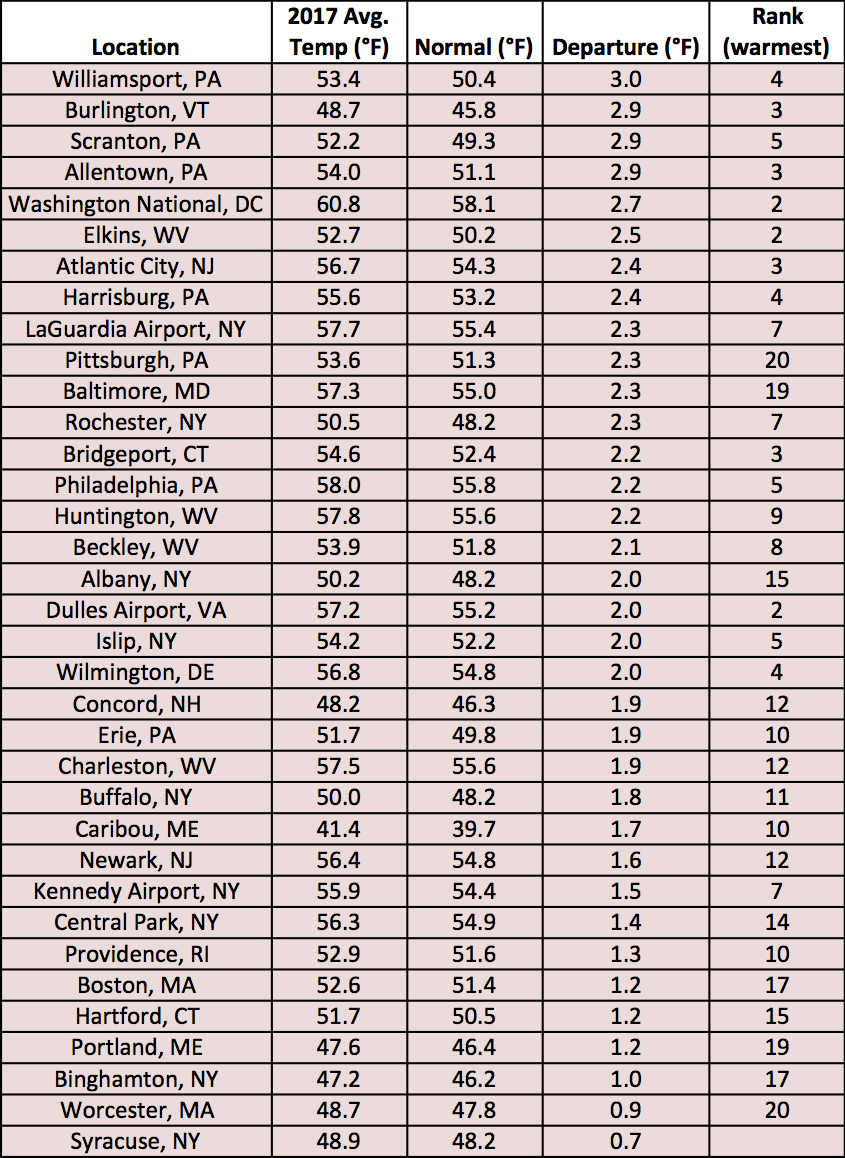
For the major climate sites, average temperatures in 2017 ranged from 0.7°F above normal in Syracuse, NY to 3.0°F above normal in Williamsport, PA.
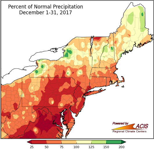
A large portion of the Northeast was drier than normal in December.
December precipitation ranged from less than 25% of normal to 200% of normal, with much of the Northeast seeing 25% to 100% of normal. The driest areas were in southern and eastern Maryland, as well as the eastern Panhandle of West Virginia, while the wettest areas were generally east of Lakes Erie and Ontario. In fact, Erie, PA, had its wettest December on record, seeing double its normal precipitation. Caribou, ME, was also wetter than normal, having its 19th wettest December on record. The remaining 33 major climate sites were drier than normal, with fifteen sites ranking this December among their 20 driest. Drought and abnormally dry conditions continued in the region during December.
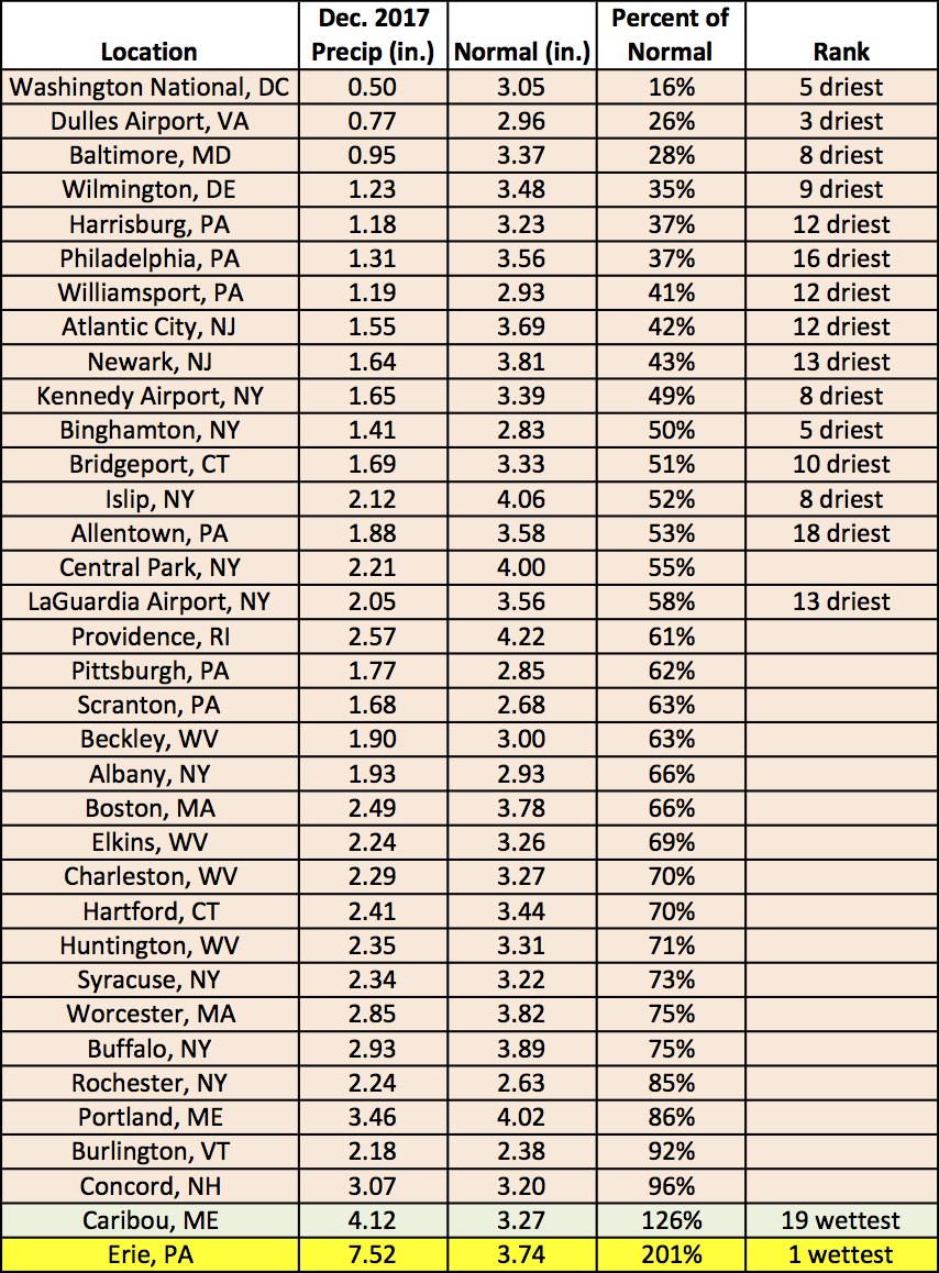
December precipitation at the major climate sites ranged from 16% of normal at Washington National, DC, to 201% of normal in Erie, PA, making it their wettest December on record.
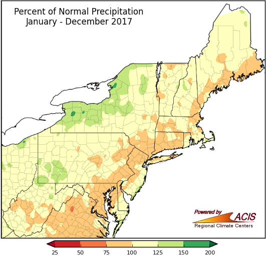
Precipitation in 2017 was near to above normal for a large portion of the Northeast.
2017 precipitation ranged from 75% to 150% of normal in the Northeast. The drier areas were generally in eastern parts of the region, while the wetter areas were generally in New York and western Pennsylvania. Of the 20 major climate sites that were wetter than normal, 11 ranked 2017 among their 20 wettest years.
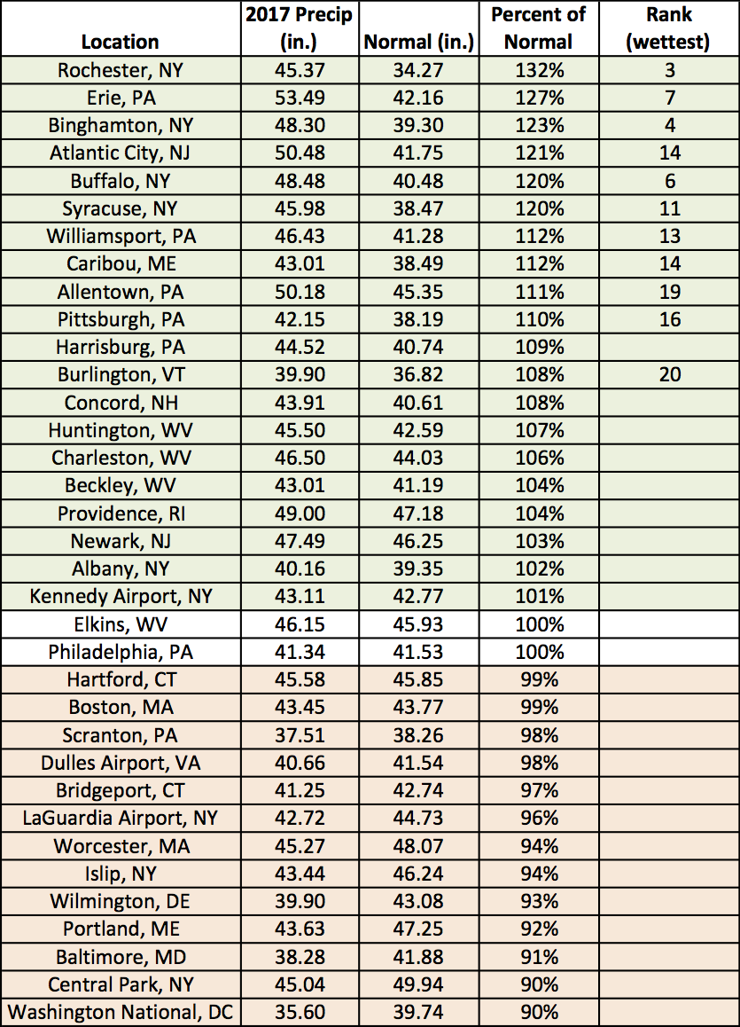
2017 precipitation at the major climate sites ranged from 90% of normal at Washington National, DC, and Central Park, NY, to 132% of normal in Rochester, NY.
(Erie, Pennsylvania snowfall records cited in the original version of this report have been removed.)