Two Tropical Systems in a Week
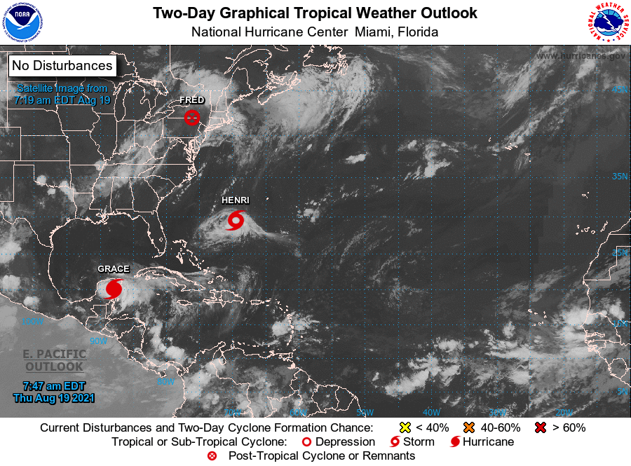
The remnants of Tropical Storm Fred located over the Northeast on August 19, 2021, with Henri in the Atlantic. Click to enlarge.
The remnants of Tropical Storm Fred moved through the Northeast from August 18 to 20. The storm spawned 10 weak (EF-0 or EF-1) tornadoes in the region, seven of which touched down in Pennsylvania. Tornado damage included snapped and uprooted trees, some of which fell on homes and cars, as well as siding and roof damage and flattened corn and wheat fields. Fred’s remnants, as well as a frontal system, produced heavy rain in several locations, including parts of central/western New York, northern Connecticut, and central Pennsylvania which saw between 4 and 8 inches of rain. Flash flooding led to impassable roads, flooded basements, stranded vehicles, and water rescues. In addition, a rare Flash Flood Emergency was declared for part of Steuben County, NY, where as many as 100 people were evacuated.
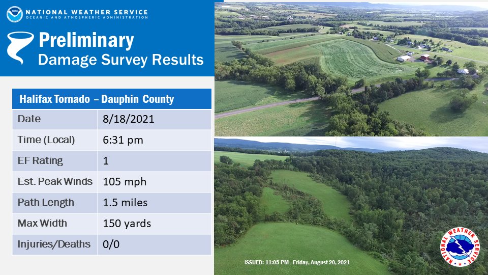
Damage from an EF-1 tornado that touched down in Dauphin County, PA. Credit - NWS State College. Click to enlarge.
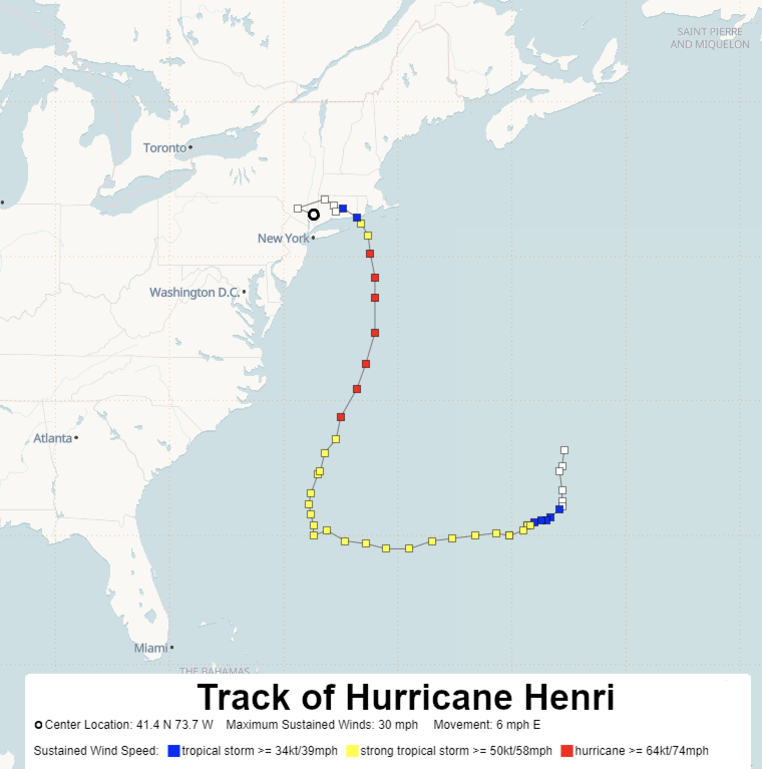
Hurricane Henri’s track from August 15 to 23. Map courtesy of NWS Binghamton.
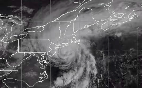
A few days later on August 22, Henri made landfall as a tropical storm near Westerly, RI, the first tropical storm or hurricane to make landfall in the state since Hurricane Bob in August 1991. Henri dropped excessive rainfall amounts of 5 to 9 inches in portions of southeastern New York, New Jersey, and eastern Pennsylvania. In fact, Central Park recorded its wettest two-day period on record for August, picking up 7.12 inches of rain from August 21 to 22. Multiple locations from eastern Pennsylvania through New Jersey and southeastern New York and into southern New England experienced flash flooding, with storm reports noting flooded basements, closed roads, stranded vehicles, and water rescues. Significant flash flooding occurred in Middlesex and Mercer counties and Newark in New Jersey, with at least 150 residents rescued or evacuated.
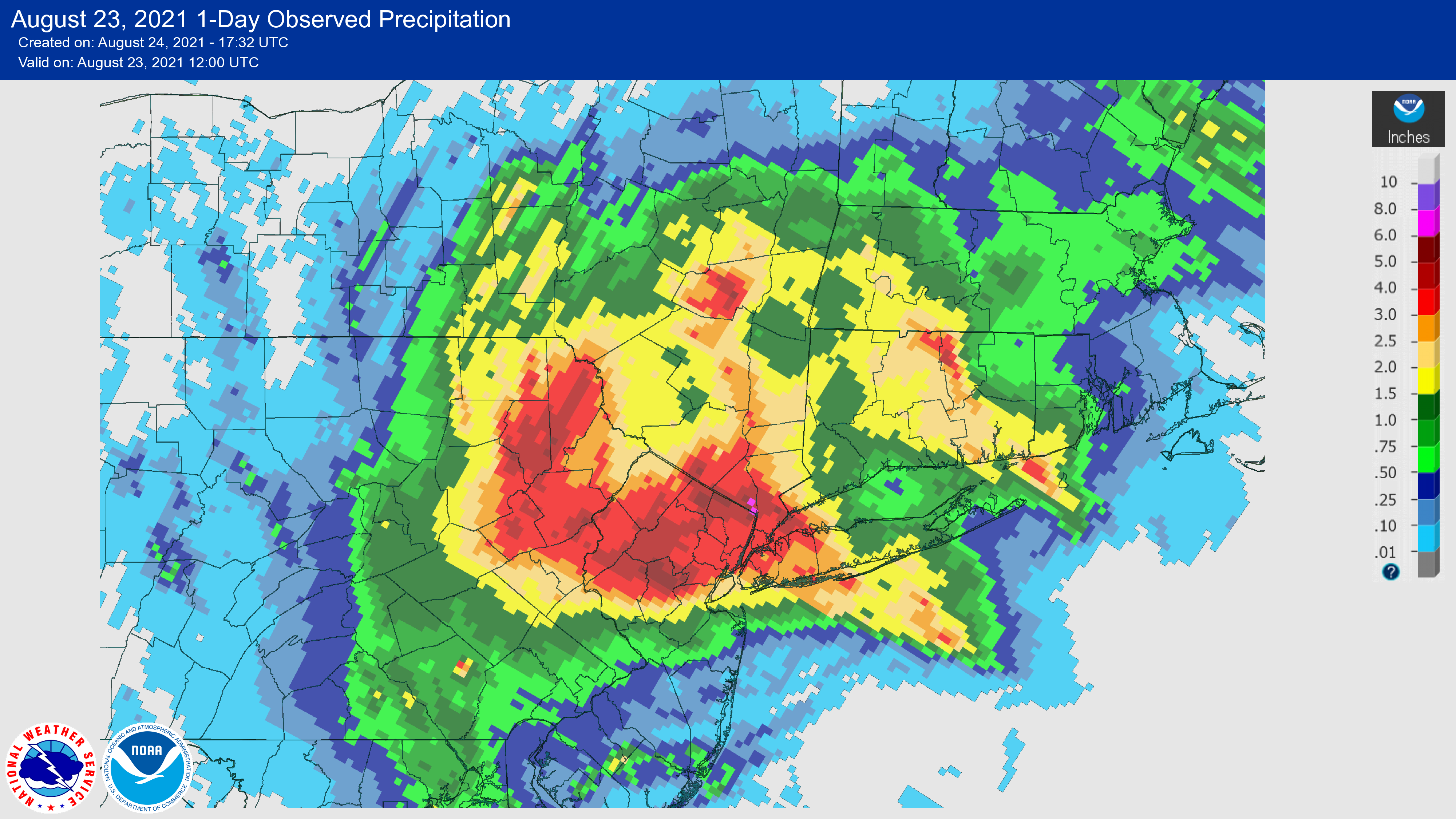
Areas shaded red saw 3 to 6 inches of rain between 8 AM on August 22 and 8 AM on August 23. Click to enlarge.
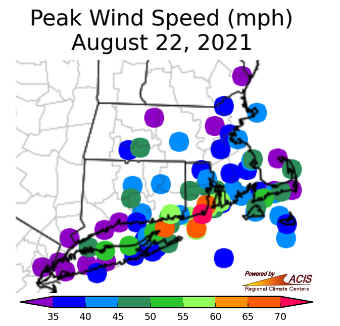
Peak wind speeds from Henri ranged from 35 to 70 mph.
Henri’s highest wind gusts reached 70 mph, bringing down trees and power lines and resulting in numerous power outages, particularly in southern New England. In addition, Henri’s remnants spawned three short-lived EF-0 tornadoes in Massachusetts, with damage consisting of a few downed trees and branches.
Hurricane Bob approaching Long Island and southern New England on August 19, 1991. Image courtesy of NOAA/NWS Lake Charles.
As mentioned above, Hurricane Bob is the most recent hurricane to make landfall in southern New England, in Newport, RI, on August 19, 1991, as a Category 2 hurricane. Bob’s sustained winds of up to 100 mph, with gusts of up to 125 mph, caused significant damage in southern New England. Heavy surf and storm surge of up to 15 feet destroyed homes, damaged boats, and caused significant beach erosion. The storm also spawned five tornadoes and dropped up to 8 inches of rain in New England and Long Island. Hurricane Bob resulted in 18 fatalities.
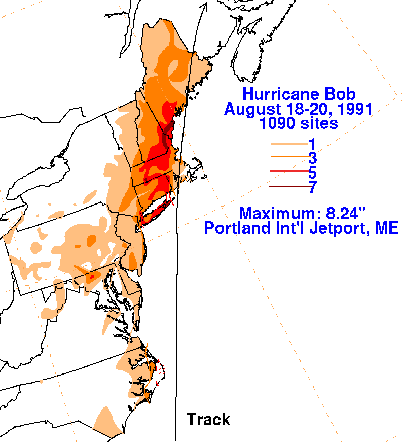
The greatest rain totals from Bob were around 8 inches. Map courtesy of NOAA.
Looking ahead, the five day tropical outlook from the National Hurricane Center shows two systems in the Atlantic that have the potential to develop into tropical depressions by the weekend. A third system is also being monitored for potential development.
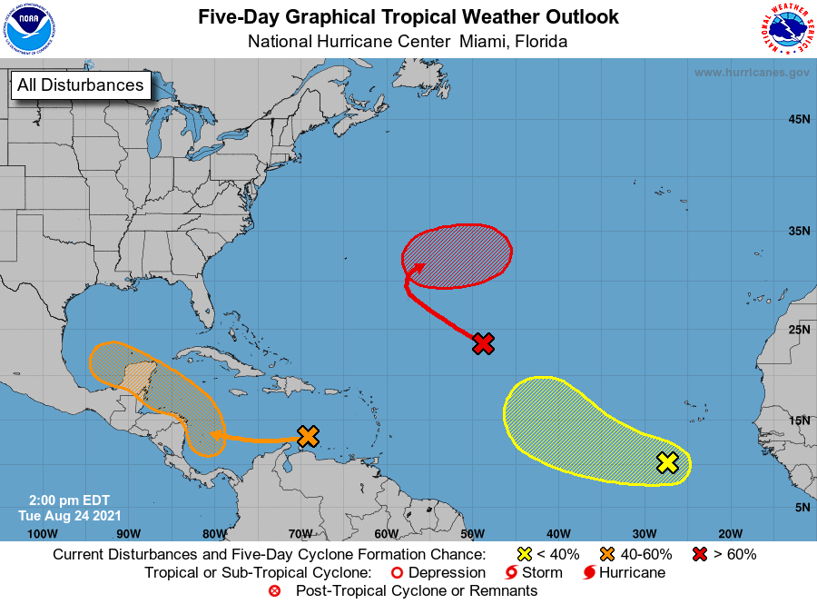
Two tropical depressions could form over the next fews days as indicated by the orange and red Xs and hatched areas on the map.