February - End of Winter or Beginning of Spring?
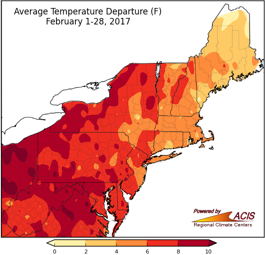
Average temperatures were well above normal for a majority of the Northeast in February.
February average temperatures in the Northeast generally ranged from 2°F to 10°F above normal. Preliminary data indicated it was the warmest February since 1895 for the region, as well as for six states. Average temperatures at the 35 major climate sites ranged from 2.3°F above normal in Caribou, ME to 9.5°F above normal in Pittsburgh, PA. Nineteen of the sites had their warmest February on record. In addition, with highs soaring into the 60s, 70s, and 80s, seven major climate sites had their warmest February day on record on the 24th or 25th.
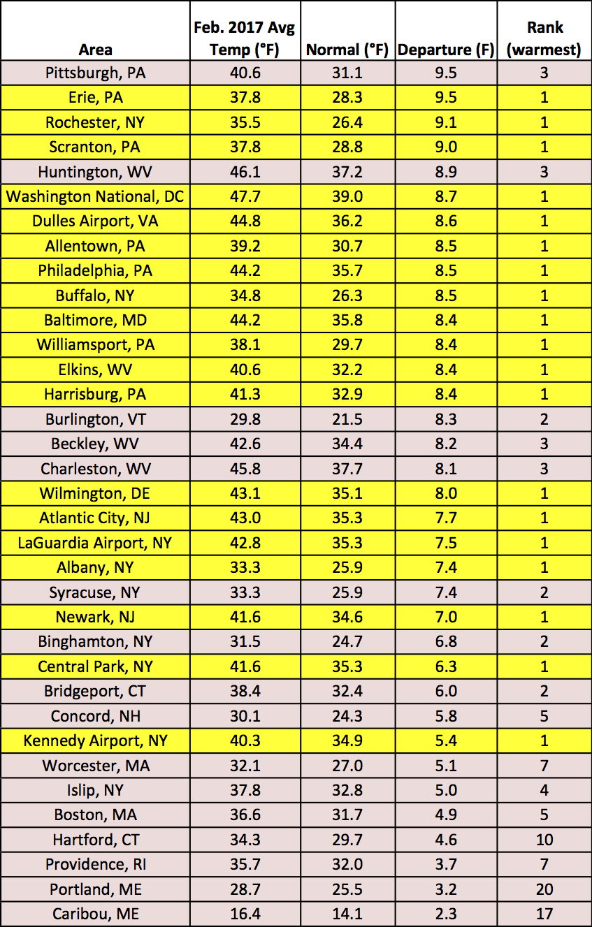
Twenty-seven major climate sites ranked this February among their top three warmest on record.
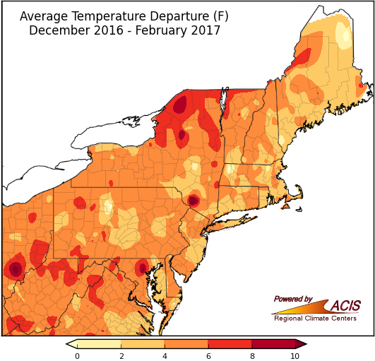
Winter also wrapped up to be warmer than normal in the Northeast.
Average temperatures during winter ranged from 2°F to 8°F for a majority of the Northeast. Preliminary data indicated this winter ranked as the fifth warmest on record for the Northeast. For the 35 major climate sites, average temperatures ranged from 2.8°F above normal in Caribou, ME to 7.4°F above normal in Burlington, VT. Dulles Airport, VA had its warmest winter on record. In addition, eight major climate sites had their warmest winter day on record on February 24th or 25th.
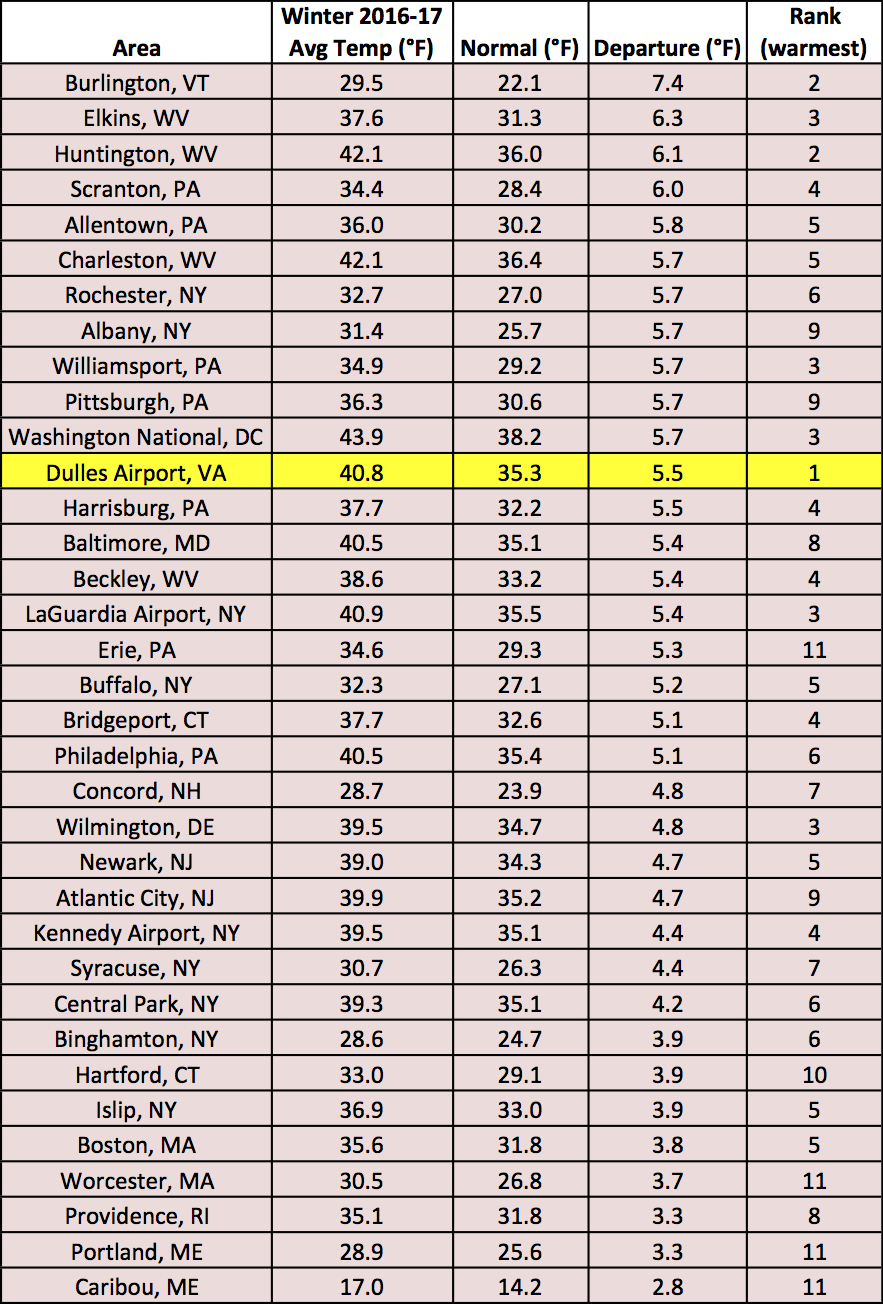
Thirty-one sites ranked this winter among their top ten warmest on record.
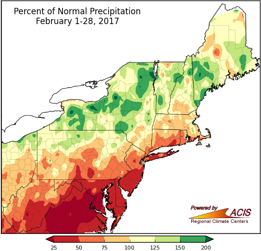
During February, southeastern areas tended to be drier than normal, while northwestern areas tended to be wetter than normal.
During February, precipitation ranged from less than 25% of normal to 200% of normal. Southern Maryland was particularly dry. This area, as well as surrounding areas, saw abnormally dry and conditions deteriorate during the month. However, wetter areas in portions of New York and New England experienced some improvement in abnormally dry and drought conditions. Twenty-six of the region’s 35 major climate sites were drier than normal in February, with twelve of those sites ranking this February among their top 20 driest. Conversely, two of the nine wetter-than-normal sites ranked this February among their top 20 wettest.
Also of note in February was the severe weather on the 25th. Four tornadoes (three EF-1s and an EF-2) touched down in the region. According to the Taunton National Weather Service office, “there has never been a tornado during the month of February since official tornado statistics have been kept, dating back to 1950” in Massachusetts.
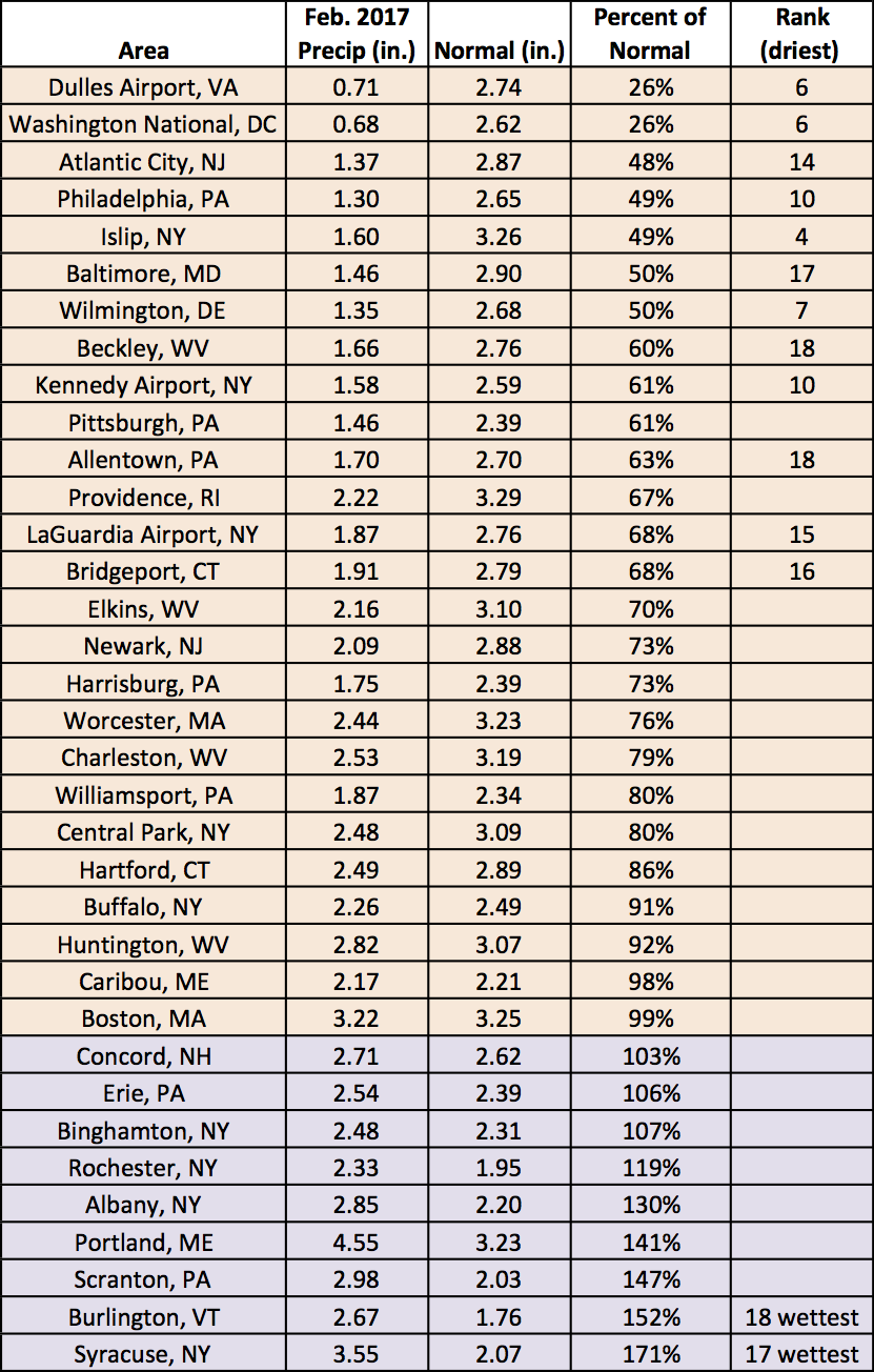
February precipitation at the major climate sites ranged from 26% of normal at Dulles Airport, VA to 171% of normal in Syracuse, NY.
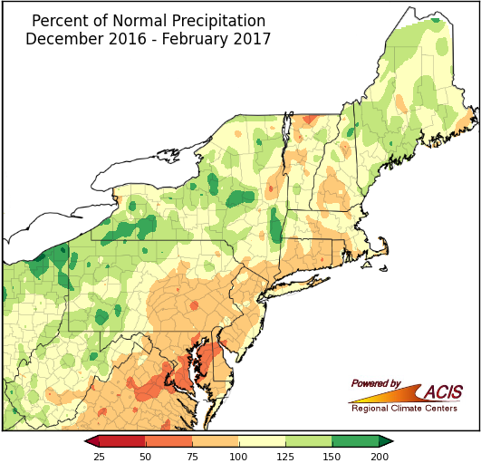
Winter precipitation ranged from 75% to 150% of normal for most of the region.
During winter, precipitation ranged from 50% of normal in portions of Maryland and Delaware to 200% of normal in portions of New York and Pennsylvania. The major climate sites were nearly split, with 18 sites wrapping up the season on the dry side of normal and 16 sites being wetter than normal. Four sites ranked this winter among their top twenty driest, while three sites ranked it among their top 20 driest.
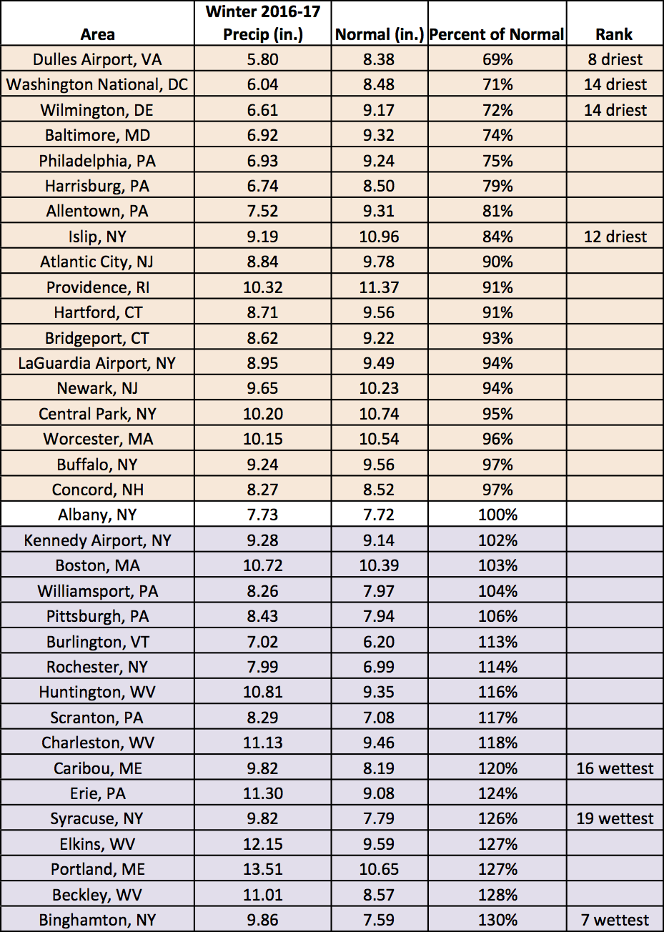
Winter precipitation at the major climate sites ranged from 69% of normal at Dulles Airport, VA to 130% of normal in Binghamton, NY.
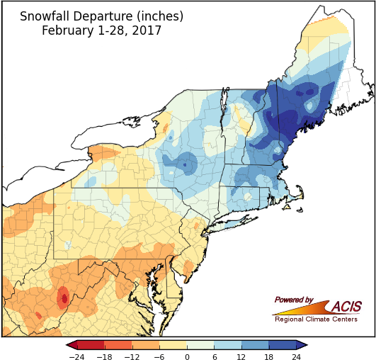
During February, southern and western areas tended to see below-normal snowfall, while northeastern areas tended to be snowier than normal.
February snowfall ranged from more than 18 inches below normal in eastern West Virginia to more than 24 inches above normal in northern New Hampshire and southern Maine. During a 10-day span from February 7 to 16, up to 60 inches, or 5 feet, of snow fell in portions of Maine. According to the National Weather Service office in Gray, the second greatest one-day snow depth on record for Maine occurred on February 16 in Andover, which had 79 inches, or 6.6 feet, of snow on the ground. On the other hand, Baltimore, MD and Huntington, WV received only a trace (less than 0.1 inches) of snow during the month, with both sites tying their records for least snowy February. Of the 35 major climate sites, 20 received below-normal snowfall, with seven of those sites ranking this February among their top 20 least snowy. Of the 15 snowier than normal sites, six ranked this February among their top 20 snowiest.
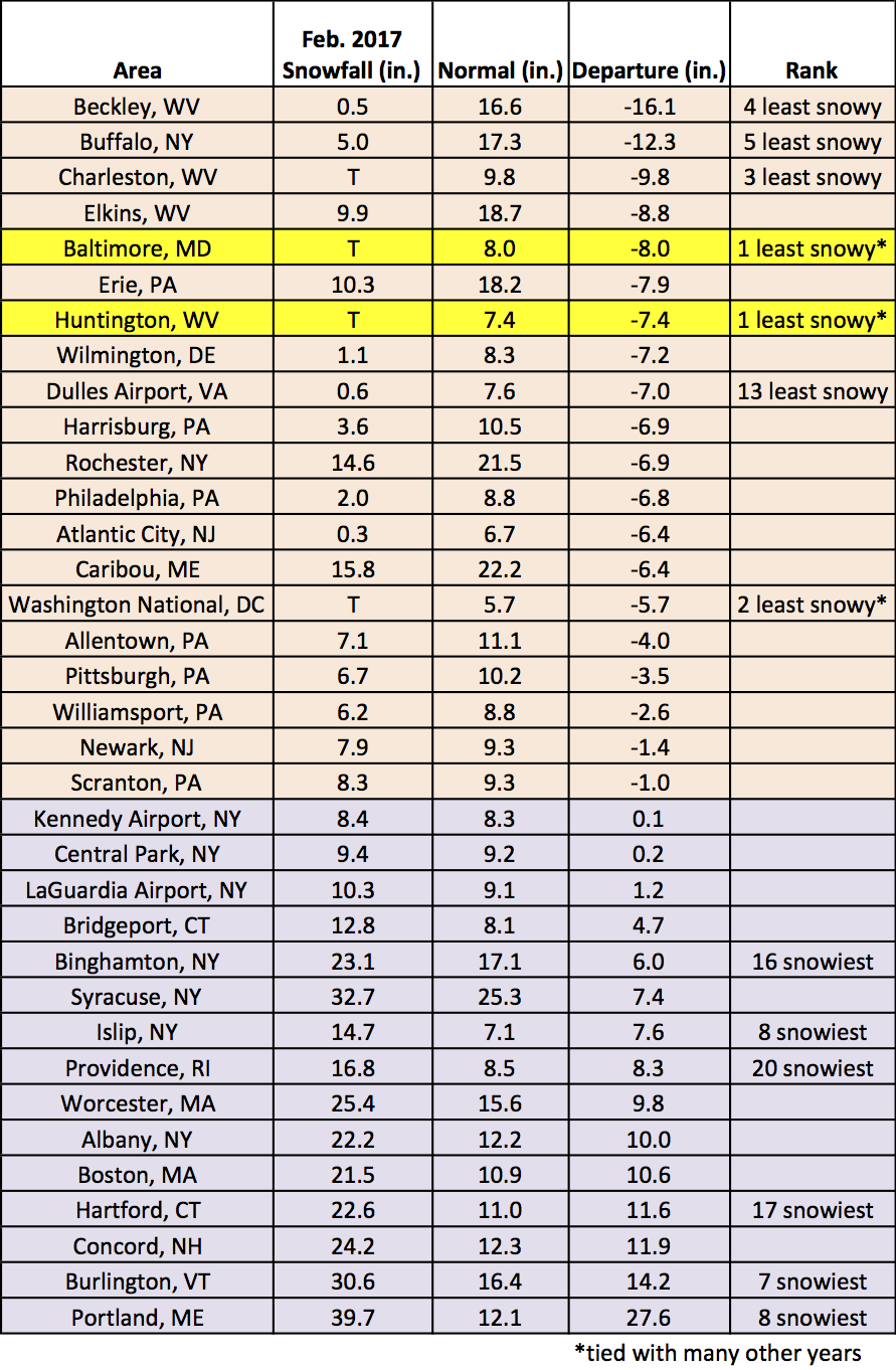
February snowfall at the major climate sites ranged from 16.1 inches below normal in Beckley, WV to 27.6 inches above normal in Portland, ME.
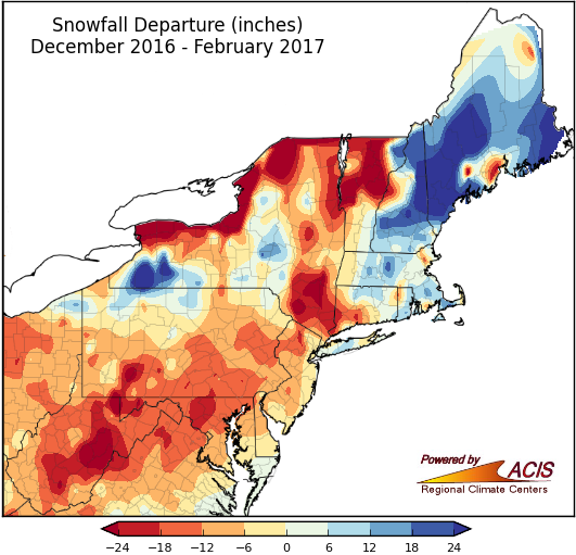
Winter snowfall was highly variable.
Winter snowfall ranged from more than 24 inches below normal to more than 24 inches above normal. Of the 35 major climate sites, 23 received below-normal snowfall, with ten of those sites ranking this winter among their top 20 least snowy. Of the 12 snowier than normal sites, four ranked this February among their top 20 snowiest.
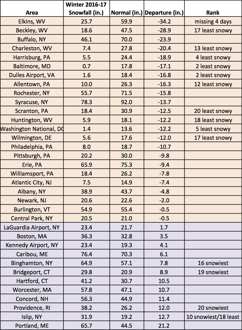
Winter snowfall at the major climate sites ranged from 34.2 inches below normal in Elkins, WV (missing four days of data) to 21.2 inches above normal in Portland, ME.