A Wet Start to July
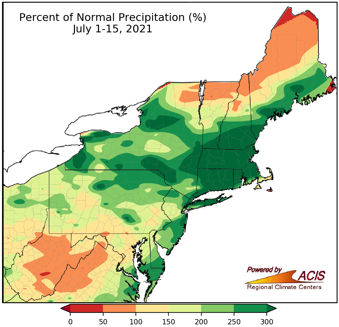
July 1-15 rainfall ranged from 50% of normal to more than 300% of normal.
There were only two days during the first half of July without flash flooding or some type of severe weather in the Northeast. On July 1, strong thunderstorm winds and several tornadoes caused damage in southern parts of the region. On July 8, downpours inundated parts of the New York City metro area, flooding several subway stations and roads. Tropical Storm Elsa produced heavy rain, strong winds, and tornadoes in the region from July 8-10. The greatest rainfall totals of over 5 inches were generally found in Connecticut and Maine, resulting in flash flooding. Wind gusts of up to 67 mph were recorded, particularly in coastal areas. Two tornadoes, as well as straight-line winds of up to 100 mph, caused damage in New Jersey. On July 12, a Flash Flood Emergency was declared for a portion of southeastern Pennsylvania and western New Jersey when as much as 10" of rain fell within a few hours, causing significant flash flooding.
Due to numerous storms, including a tropical storm, the first half of July was wetter than normal for much of the Northeast, with portions of the region seeing more than 300% of their normal July 1-15 precipitation. Rainfall at the 35 major climate sites ranged from 57% of normal in Caribou, ME, to 574% of normal in Boston, MA. Eight major climate sites experienced their wettest first half of July on record and another 17 of the sites ranked this July 1-15 period among their 20 wettest on record. In fact, for 12 of the major climate sites, it is already one of the 20 wettest Julys on record. However, several areas including portions of Maine, northern New Hampshire and Vermont, northeastern New York, and a chunk of West Virginia, missed out on the heavy rain, seeing 50% to 100% of normal precipitation. Drought and abnormally dry conditions persisted in some of these locations but improved in wetter spots.
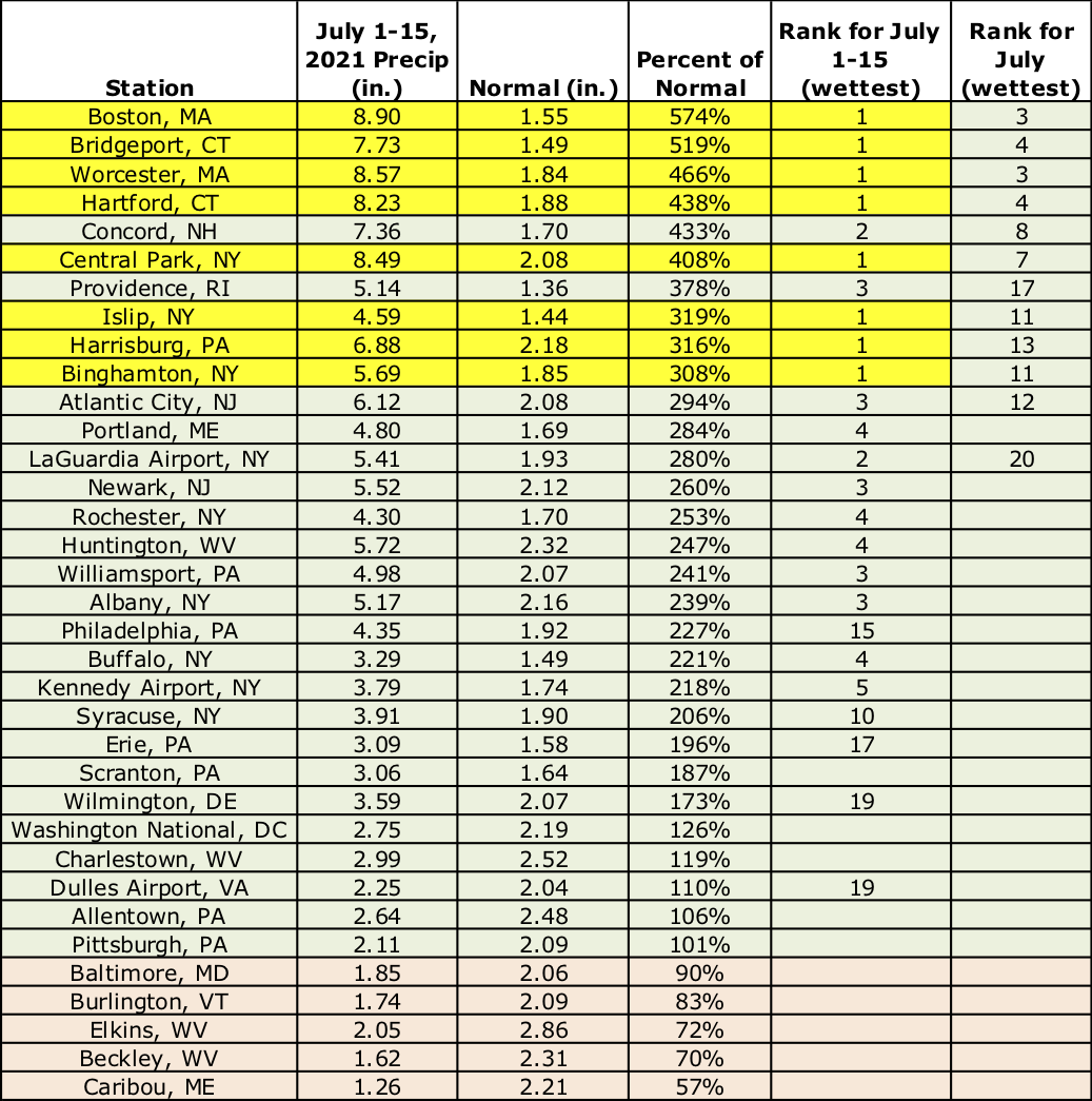
This July 1-15 period was record wet for eight major climate sites.
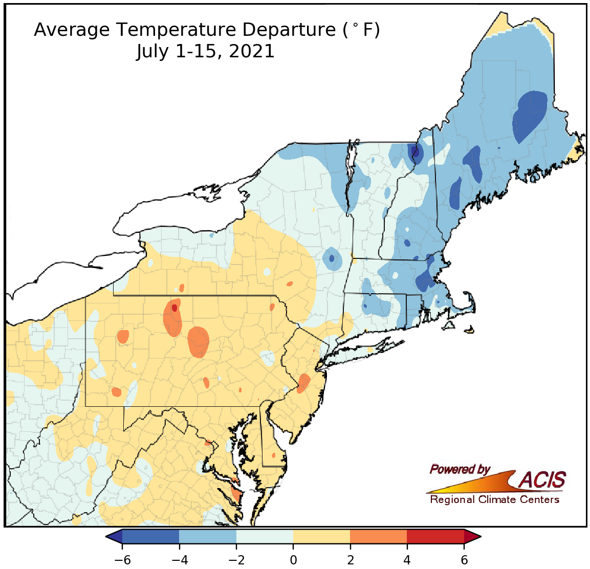
July 1-15 average temperatures ranged from 6°F below normal to 4°F above normal.
Average temperatures during the first half of July varied, ranging from 6°F below normal in parts of New England to 4°F above normal in parts of Pennsylvania and New Jersey. At the major climate sites, average temperatures ranged from 3.9°F below normal in Portland, ME, to 1.7°F above normal in Baltimore, MD. This July 1-15 period ranked among the 20 coolest on record for two major climate sites but among the 20 warmest for six major climate sites.
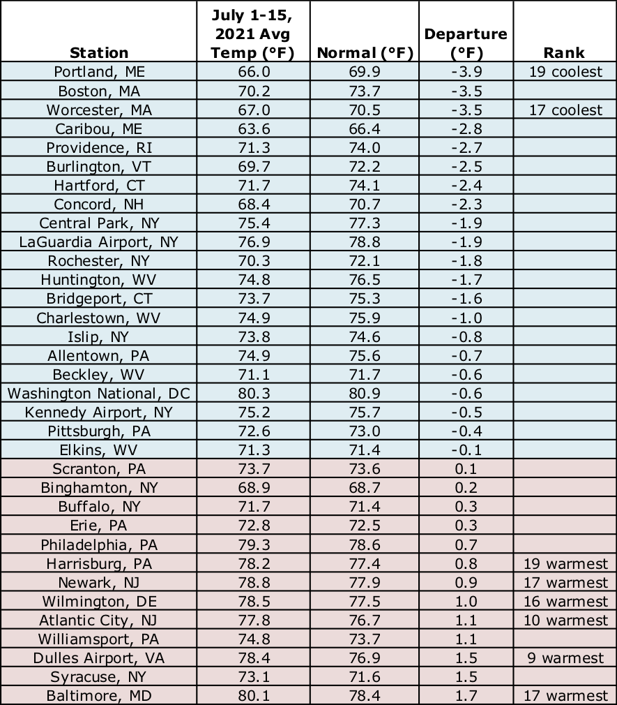
This July 1-15 period ranked among the 20 coolest on record for two major climate sites but among the 20 warmest for six major climate sites.
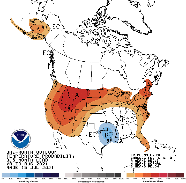
There’s a tilt toward warmer-than-normal temperatures for the rest of July.
The rest of July is expected to be warmer than normal for most of the Northeast, with the greatest likelihood in New England and eastern New York, according to NOAA’s Climate Prediction Center. There’s a tilt toward wetter-than-normal conditions for the remainder of July in southern parts of the Northeast, while equal chances of below-, near-, or above-normal precipitation was predicted for northern locations.
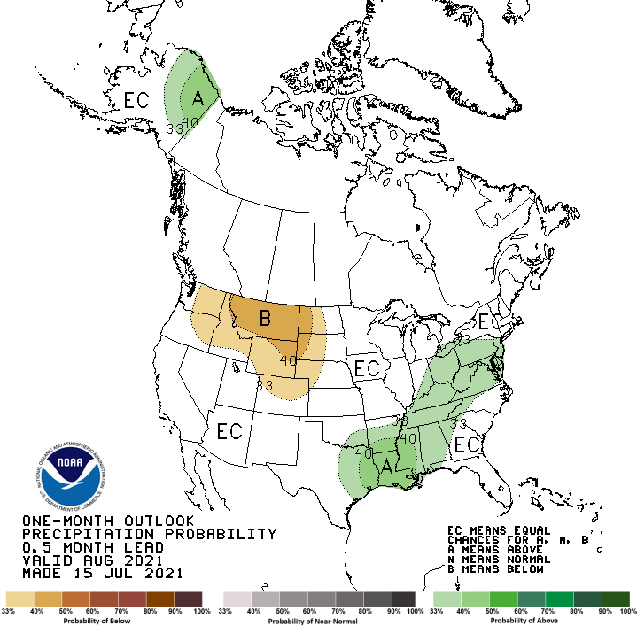
Southern parts of the Northeast could be wetter-than-normal for the remainder of July.