Mid-April Had It All
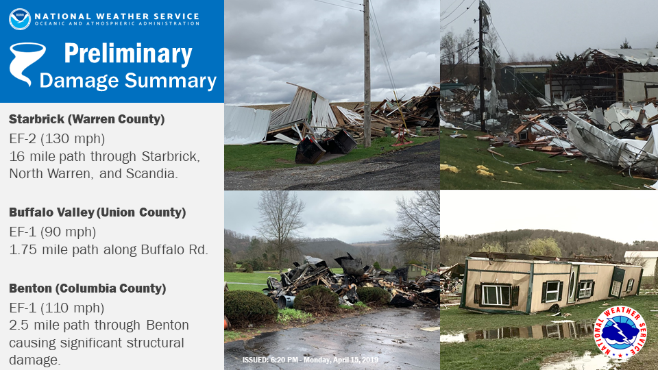
Preliminary damage summary from three tornadoes that touched down in the State College, PA, National Weather Service forecast area. Image courtesy NWS CTP. Click image to enlarge.
The first half of April wrapped up with a severe weather outbreak. On April 14 and 15 severe storms produced several tornadoes, damaging winds, and hail in the Northeast. Storm surveys were ongoing but as of midday on April 16 nine tornadoes had been confirmed - eight in Pennsylvania (three EF-0s, three EF-1s, an EF-2, and one still being determined) and one in Delaware (an EF-2). Thunderstorms also produced wind gusts of up to 80 mph. The storms downed numerous trees and damaged buildings and homes, removing the roofs of some and completely destroying others. Large hail was also reported. The same storm system produced heavy rain, over 2 inches in some areas, leading to flooding and closed roads.
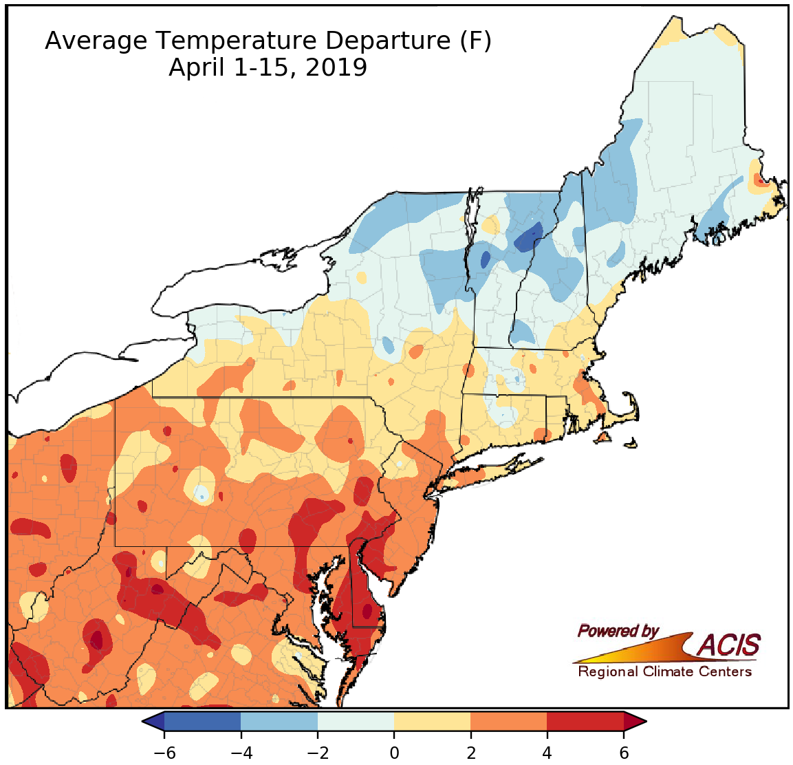
April 1-15 average temperatures ranged from 4°F below normal to 6°F above normal.
Average temperatures during the first half of April were wide ranging, with the line between below normal and above normal generally running across the middle of New York and New England. April 1-15 average temperatures ranged from 4°F colder than normal in parts of northern New England and northern New York to 6°F warmer than normal in parts of West Virginia, Pennsylvania, and the Mid-Atlantic. At the region’s 35 major climate sites, April 1-15 average temperatures ranged from 0.7°F below normal in Caribou, ME, to 6.3°F above normal in Allentown, PA. A majority, 31 sites, were warmer than normal, with 19 of them ranking this first half of April among their 20 warmest on record.
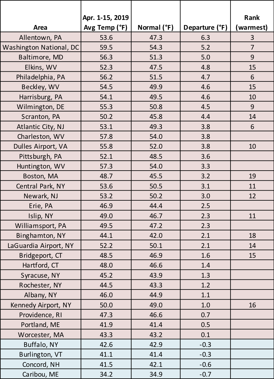
The April 1-15 period of 2019 ranked among the 20 warmest at 19 major climate sites.
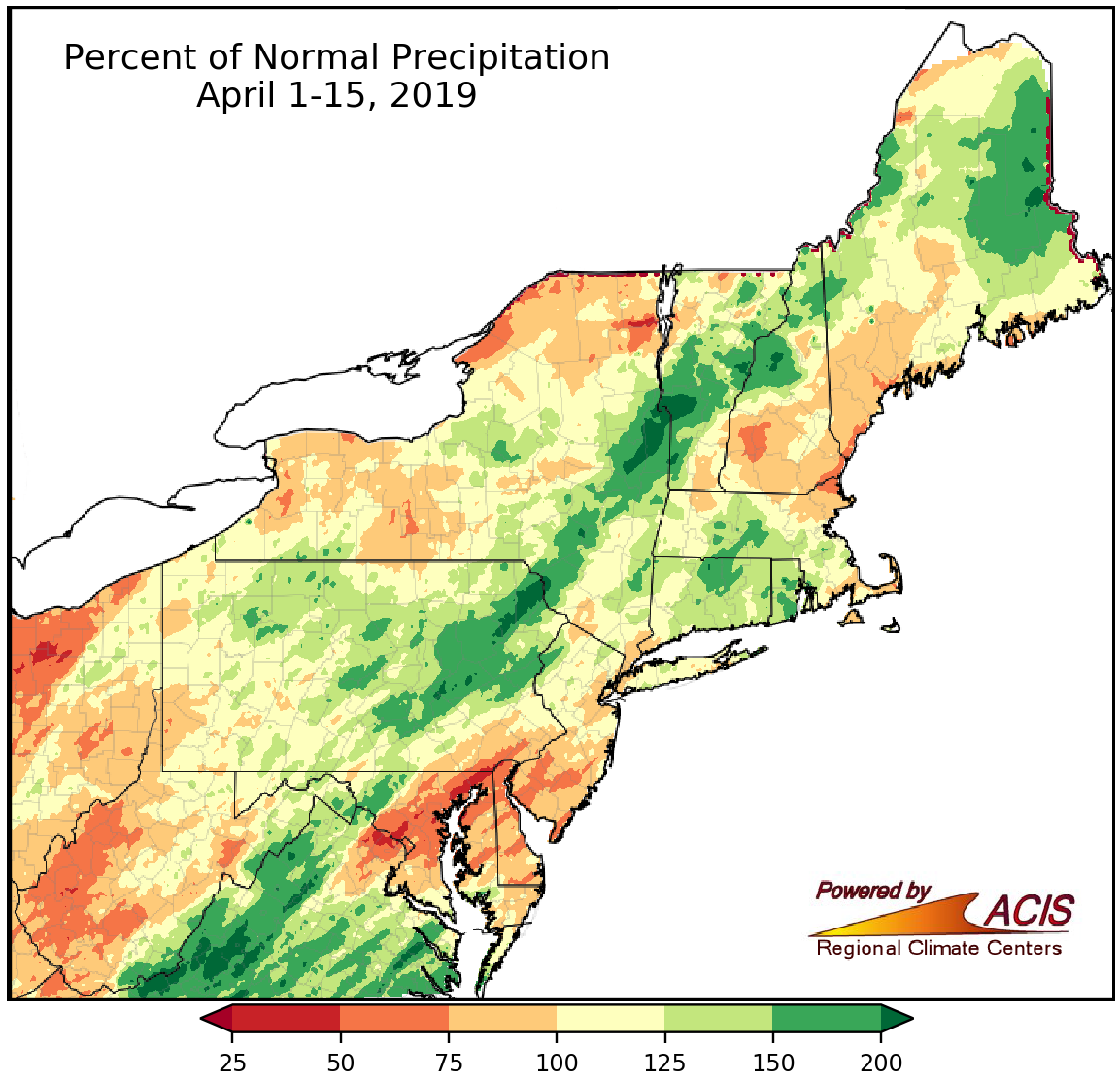
Precipitation during the first half of April ranged from 25% of normal to more than 200% of normal.
Precipitation was also wide ranging, from 25% of normal in parts of Maryland to more than 200% of normal in northeastern Pennsylvania, eastern New York, and parts of northern New England. The 35 major climate sites were nearly split - 16 sites experienced below-normal precipitation and 18 sites had above-normal precipitation. April 1-15 precipitation ranged from 37% of normal in Baltimore, MD, to 185% of normal in Hartford, CT, with Dulles Airport, VA, having its 17th driest April 1-15 period and seven sites ranking the period among their 20 wettest. Abnormally dry conditions returned to the region in mid-April. Due to below-normal precipitation and low streamflow, abnormal dryness was introduced in western New York and central West Virginia in the U.S. Drought Monitor released April 11.
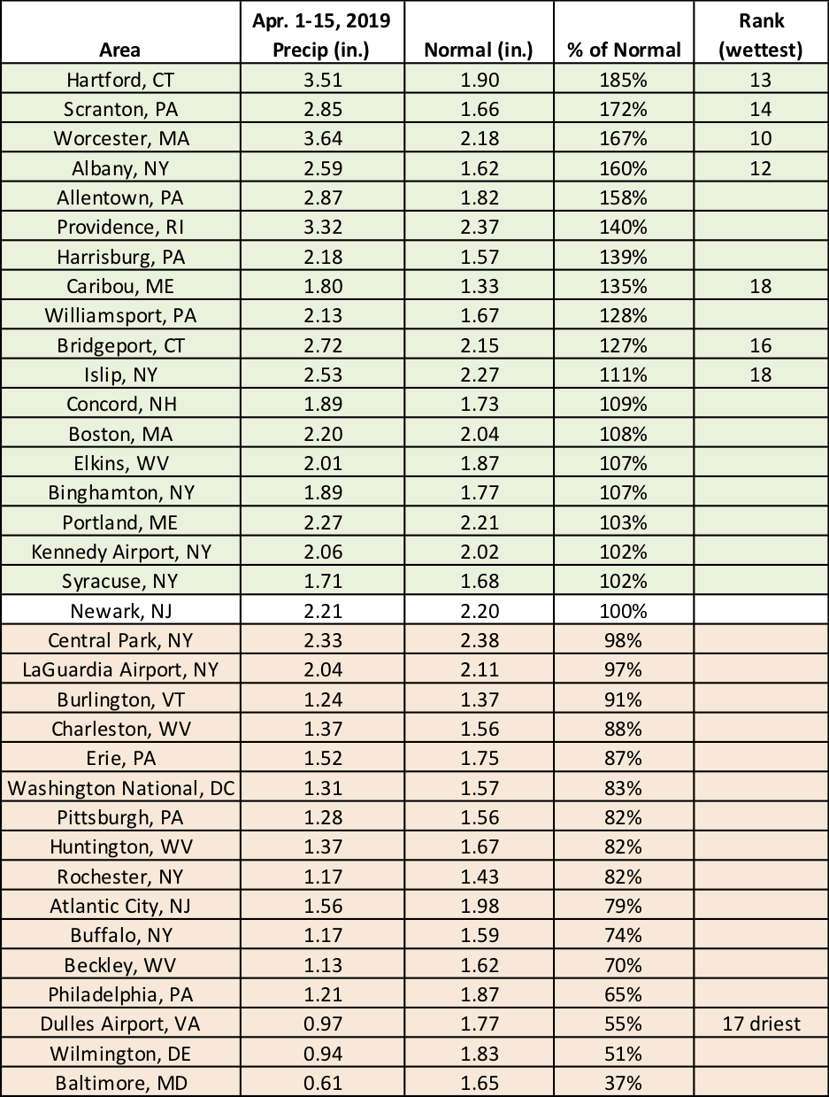
Dulles Airport, VA, had its 17th driest April 1-15 period, while seven sites ranked the period among their 20 wettest.
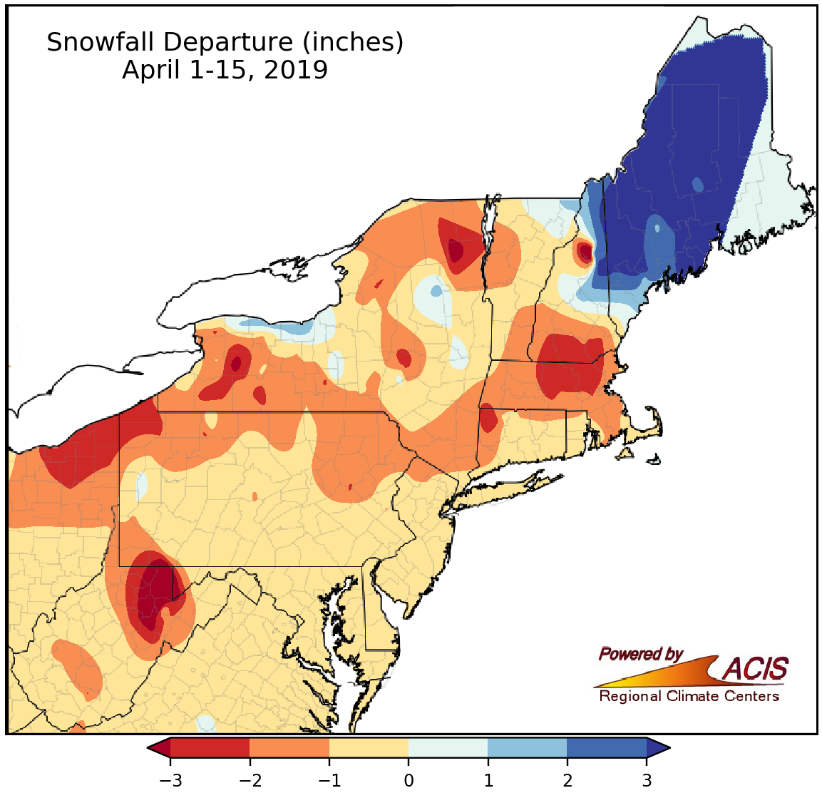
April 1-15 snowfall ranged from more 3 inches below normal to more than 3 inches above normal.
April 1-15 snowfall was near to below normal for much of the region, with the largest deficits of more than 3 inches in northern West Virginia. Conversely, the largest surplus of more than 3 inches was found in Maine and eastern New Hampshire. Thirty-two of the region’s 35 major climate sites received normal or below-normal snowfall, with the greatest deficit of 4.1 inches in Elkins, WV. Of the three sites with above-normal snowfall, Caribou, ME, had the largest surplus, 5.6 inches, which made it their 12th snowiest April 1-15 period. The site broke a record in mid-April - it had its greatest number of consecutive days with at least 1 inch of snow on the ground. As of April 15, the record was at 157 days (starting November 10, 2018) and Caribou still had 11 inches of snow on the ground.
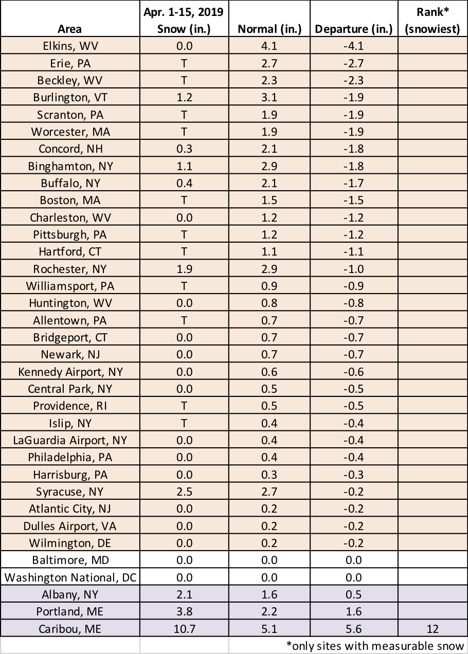
A majority of the major climate sites received normal or below-normal snowfall during the first half of April.
For the rest of April, NOAA’s Climate Prediction Center favors above-normal temperatures for the whole Northeast and near- to below-normal precipitation for much of the region.
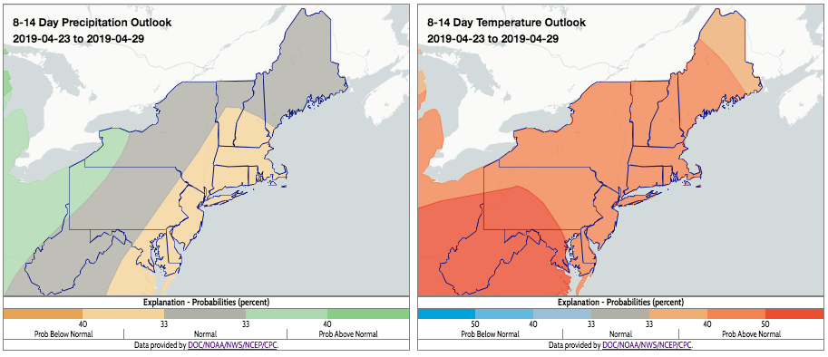
The 8-14 day outlooks from NOAA indicate above-normal temperatures and near- to below-normal precipitation are favored for most areas. Click image to enlarge.