Broken Records - December and 2023
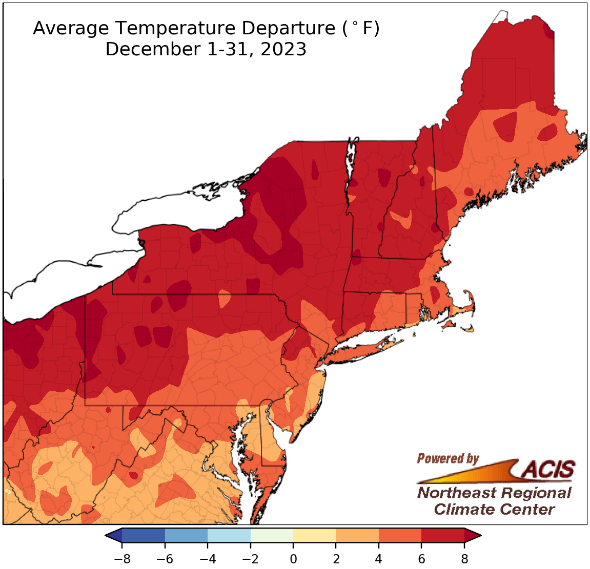
December average temperatures ranged from 2°F above normal to more than 8°F above normal.
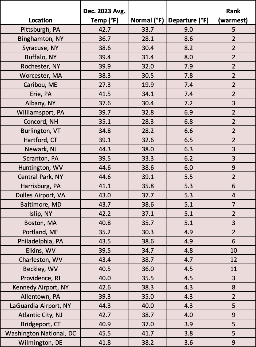
The last month of 2023 wrapped up like many other months before it - on the warm side of normal. December average temperatures ranged from 2°F above normal to more than 8°F above normal, with the greatest departures above normal in parts of Pennsylvania and New York. This December ranked among the five warmest Decembers on record for 25 of the Northeast’s 35 major climate sites, with the remaining 10 sites experiencing one of the 12 warmest Decembers. Overall, December average temperatures at the major climate sites ranged from 3.6°F above normal in Wilmington, DE, to 9.0°F above normal in Pittsburgh, PA.
This December ranked among the five warmest Decembers on record for 25 major climate sites, with the other 10 sites seeing one of their 12 warmest Decembers.
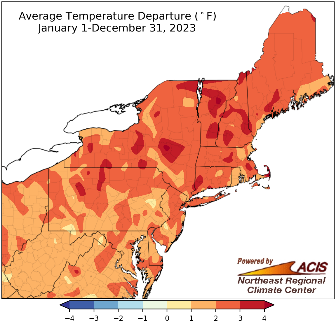
Average temperatures for 2023 ranged from near normal to more than 4°F above normal.
With multiple warmer-than-normal months, annual average temperatures for 2023 ranged from near normal to more than 4°F above normal. In fact, 2023 became the warmest year on record for 13 major climate sites and ranked among the 10 warmest years on record for another 20 major climate sites. The remaining two sites had one of their 20 warmest years. Annual average temperatures for the 35 sites ranged from 0.5°F above normal in Allentown, PA, to 3.5°F above normal in Binghamton, NY, and Worcester, MA.
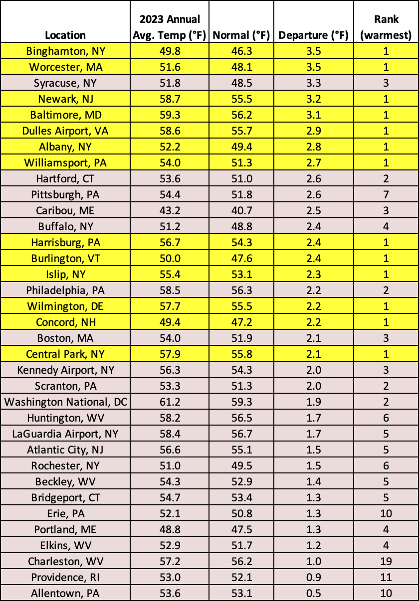
2023 was record warm for 13 major climate sites, among the 10 warmest years for another 20 of the sites, and among the 20 warmest for two sites.
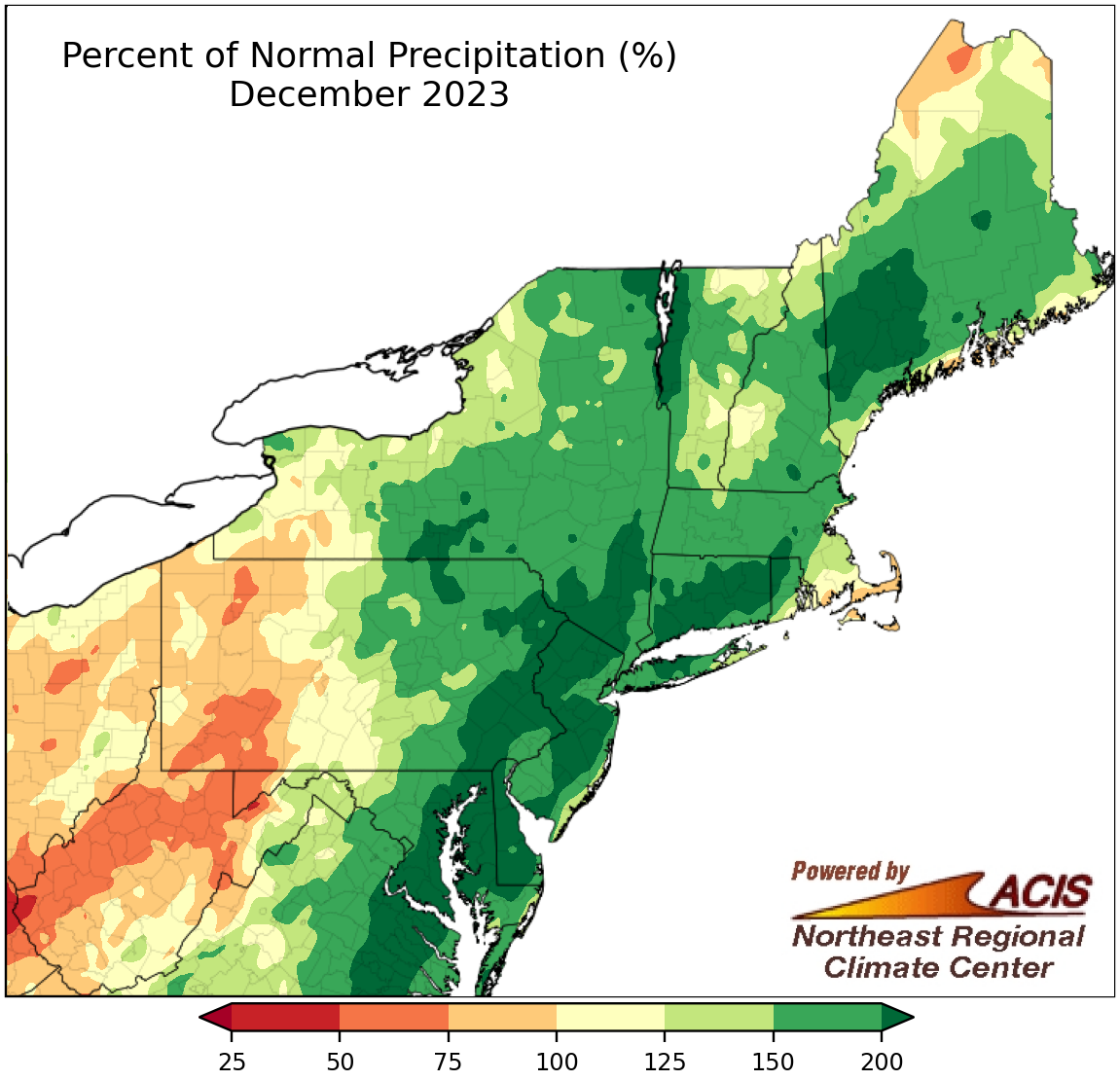
December precipitation ranged from 50% of normal to more than 200% of normal.
December’s precipitation pattern resembled what would be expected during an El Niño winter - drier-than-normal conditions in interior locations such as western Pennsylvania and West Virginia and wetter-than-normal conditions in coastal areas. With that, December precipitation ranged from 50% of normal to more than 200% of normal. At the region’s 35 major climate sites, December precipitation ranged from 53% of normal in Huntington, WV, to 231% of normal in Burlington, VT, with 28 sites being wetter than normal. Two sites closer to the coast, Allentown, PA, and Bridgeport, CT, had their wettest December on record, while another 23 major climate sites saw one of their 12 wettest Decembers. At the opposite extreme, Huntington recorded its 18th driest December.
December 18 was particularly wet, ranking among the 10 wettest December days on record at 13 major climate sites, with most seeing over 2 inches of precipitation. Notably, December 28 became the wettest December day on record for Islip, NY, with 3.04 inches of precipitation.
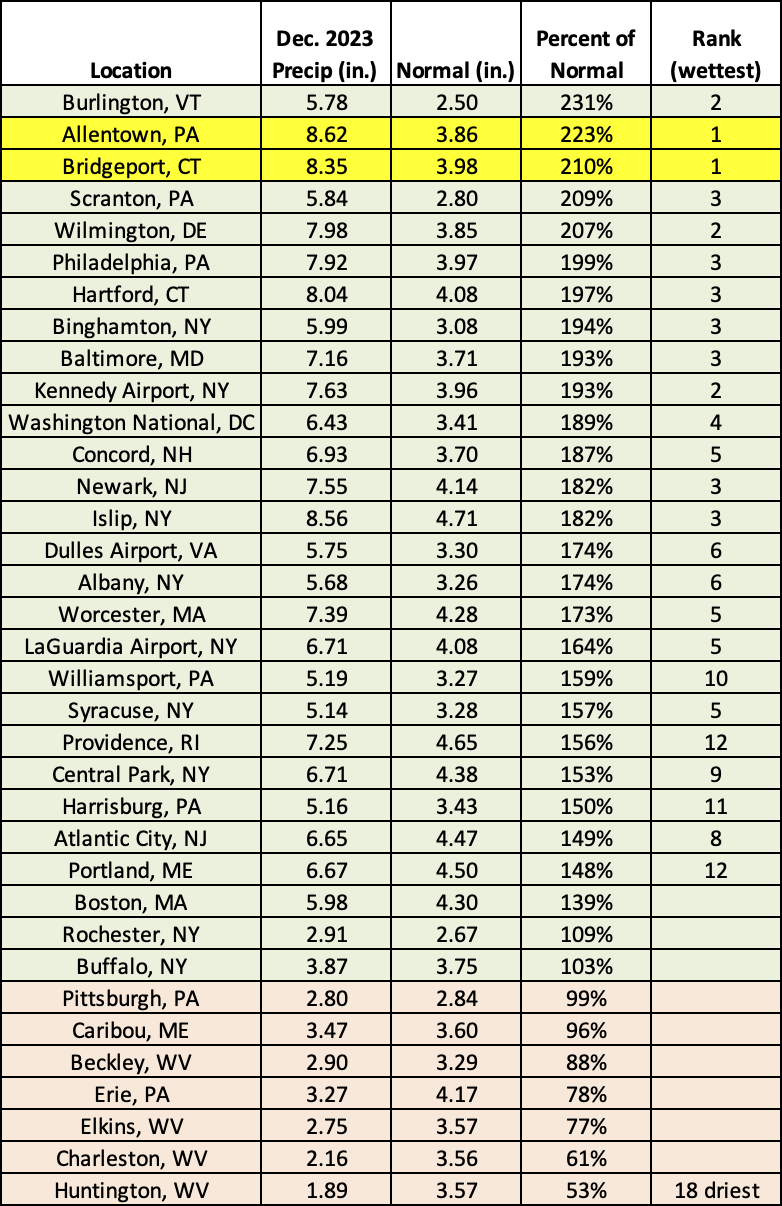
This December was record wet for two sites and among the 12 wettest for another 23 of the sites. Meanwhile, Huntington, WV, had its 18th driest December.
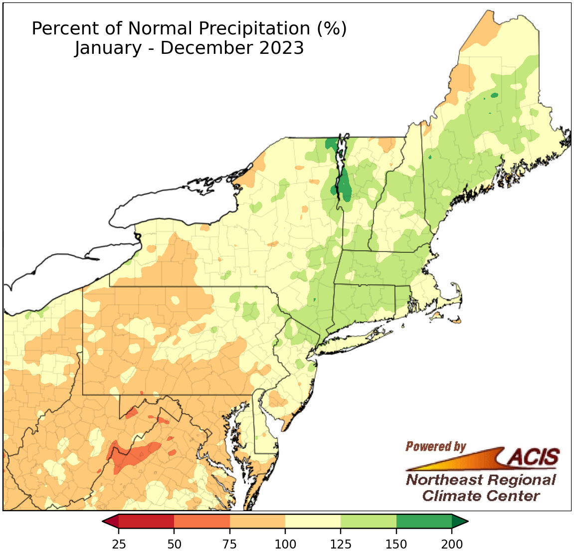
2023 precipitation ranged from 75% of normal to 150% of normal for most of the Northeast.
2023 featured precipitation extremes including intensifying drought in parts of the Mid-Atlantic and western New York and record rainfall in areas such as northern New England. Annual precipitation in the Northeast generally ranged from 75% of normal in interior and southern locations to 150% of normal in coastal and northern locations. Precipitation for 2023 at the 35 major climate sites ranged from 75% of normal in Huntington, WV, to 138% of normal in Hartford, CT, with 21 sites being wetter than normal. 2023 ranked among the 20 driest years on record for three major climate sites but among the 20 wettest for 20 sites.
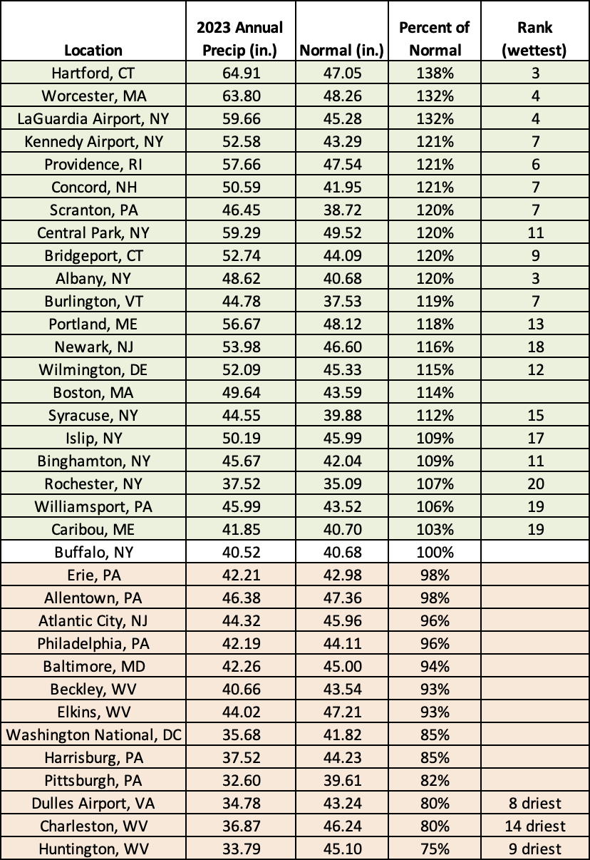
2023 ranked among the 20 driest years on record for three major climate sites but among the 20 wettest for 20 sites.
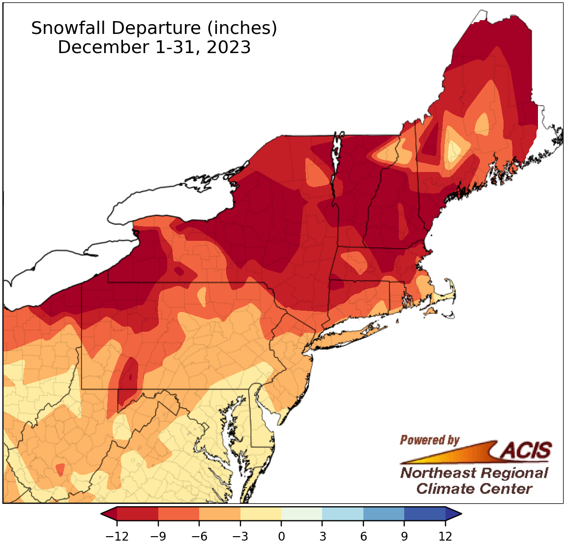
December snowfall ranged from more than 12 inches below normal to near normal.
Snow was hard to find in the Northeast during December, with the entire region running a snowfall deficit. The largest deficits of over 12 inches were found in New England, New York, and northwestern Pennsylvania. December snowfall at the 35 major climate sites ranged from 25.8 inches below normal in Syracuse, NY, to 1.6 inches below normal in Washington, D.C. This December tied as the least snowy on record for Worcester, MA, and Hartford, CT, both with only a trace, and ranked among the 20 least snowy for another 26 of the sites. Interestingly, a brief snow event allowed sites like Wilmington, DE; Dulles Airport, VA; and Charleston, WV, to see as much as or more snow than sites like Worcester, MA; Concord, NH; and Portland, ME.
The lack of snow this December is a continuation of a longer-term trend in a handful of major Northeast cities. For instance, Baltimore, MD, and Philadelphia, PA, haven’t recorded over an inch of snow since late January 2022, over 700 days or near two years, their longest such streaks on record. Central Park, NY, and Dulles Airport, VA, are in a similar situation, not seeing over an inch of snow since mid-February 2022 and mid-March 2022, also record-long streaks.
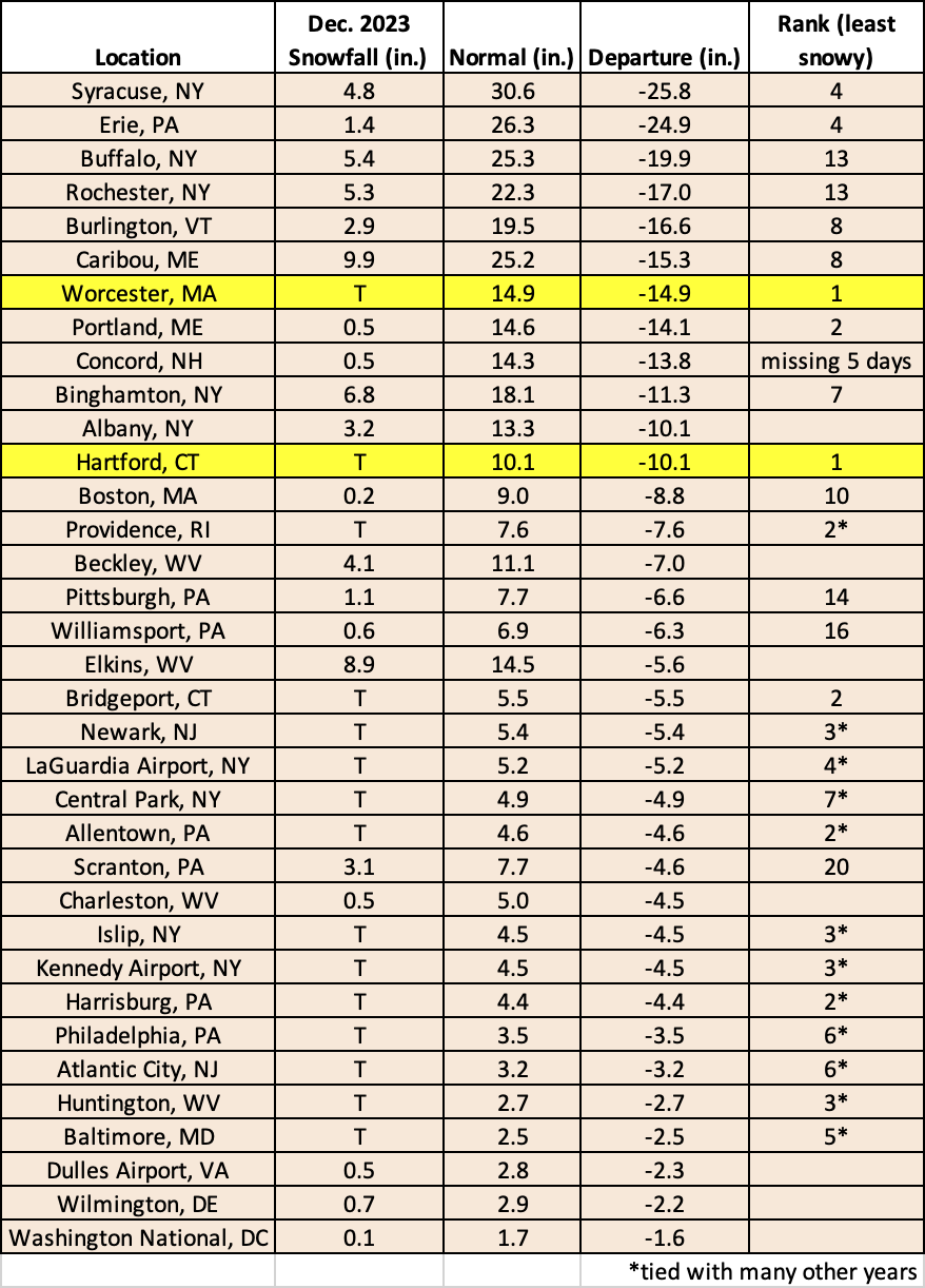
This December tied as the least snowy on record for Worcester, MA, and Hartford, CT, and ranked among the 20 least snowy for another 26 of the sites.
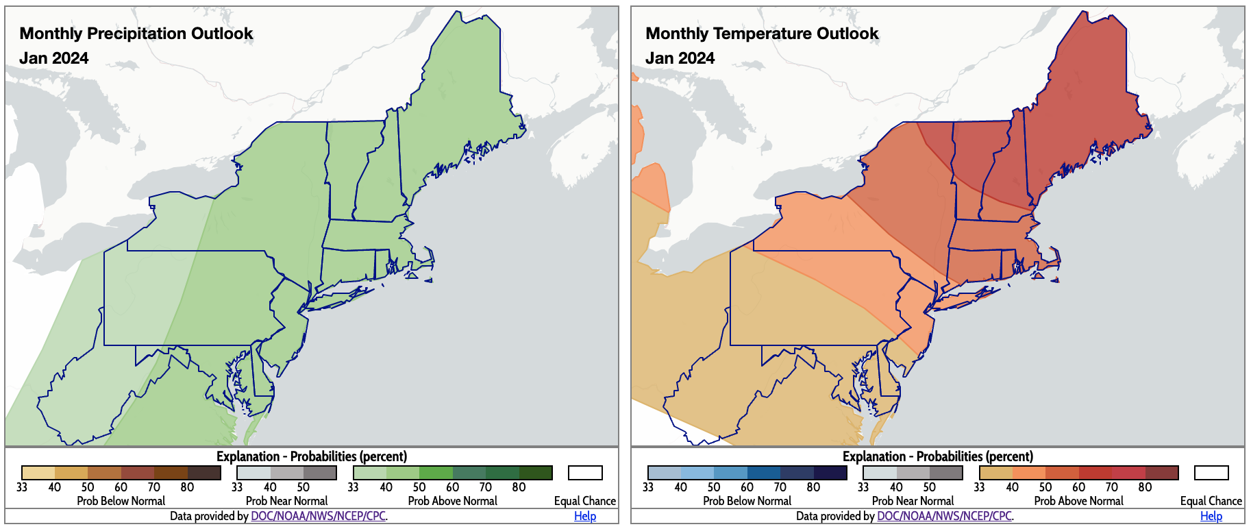
January is predicted to be wetter and warmer than normal for almost the entire Northeast. Click to enlarge.
The January outlooks from NOAA’s Climate Prediction Center show a tilt toward above-normal precipitation for the entire Northeast, with above-normal temperatures favored for all the region except extreme southern West Virginia.