A Wicked Warm Start to September
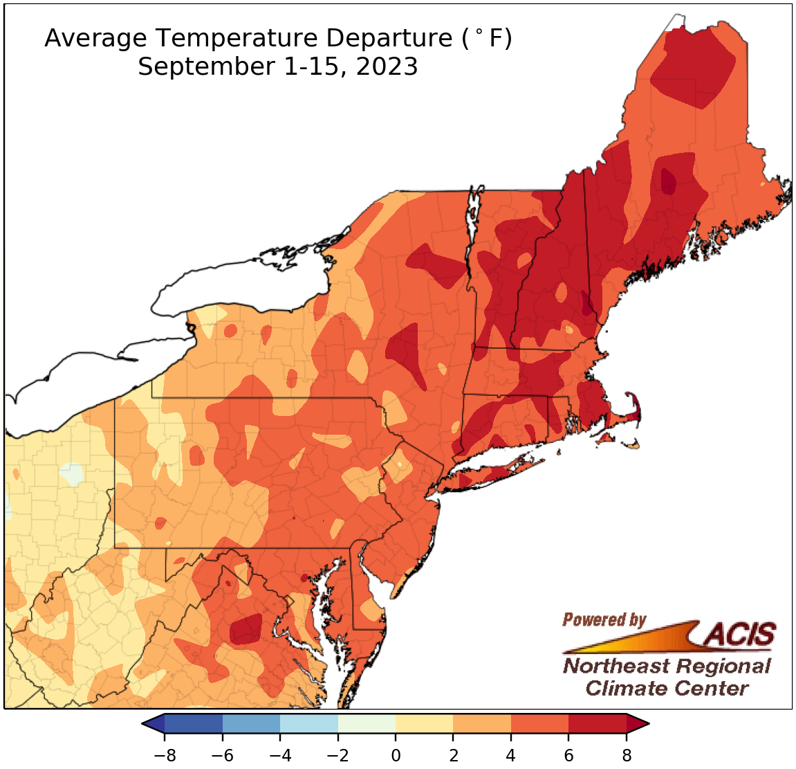
September 1-15 average temperatures ranged from near normal to 8°F above normal.
September has been a warm one so far, with average temperatures running up to 8°F above normal. Areas closer to the coast including a large chunk of New England saw the greatest departures above normal, while interior areas such as West Virginia and western Pennsylvania tended to be closer to normal. At the 35 major climate, sites, September 1-15 average temperatures ranged from 0.5°F above normal in Elkins, WV, to 7.1°F above normal in Worcester, MA. This first half of September was record warm for Worcester, MA; Dulles Airport, VA; Islip, NY; and Philadelphia, PA, and among the 10 warmest for another 20 of the sites.
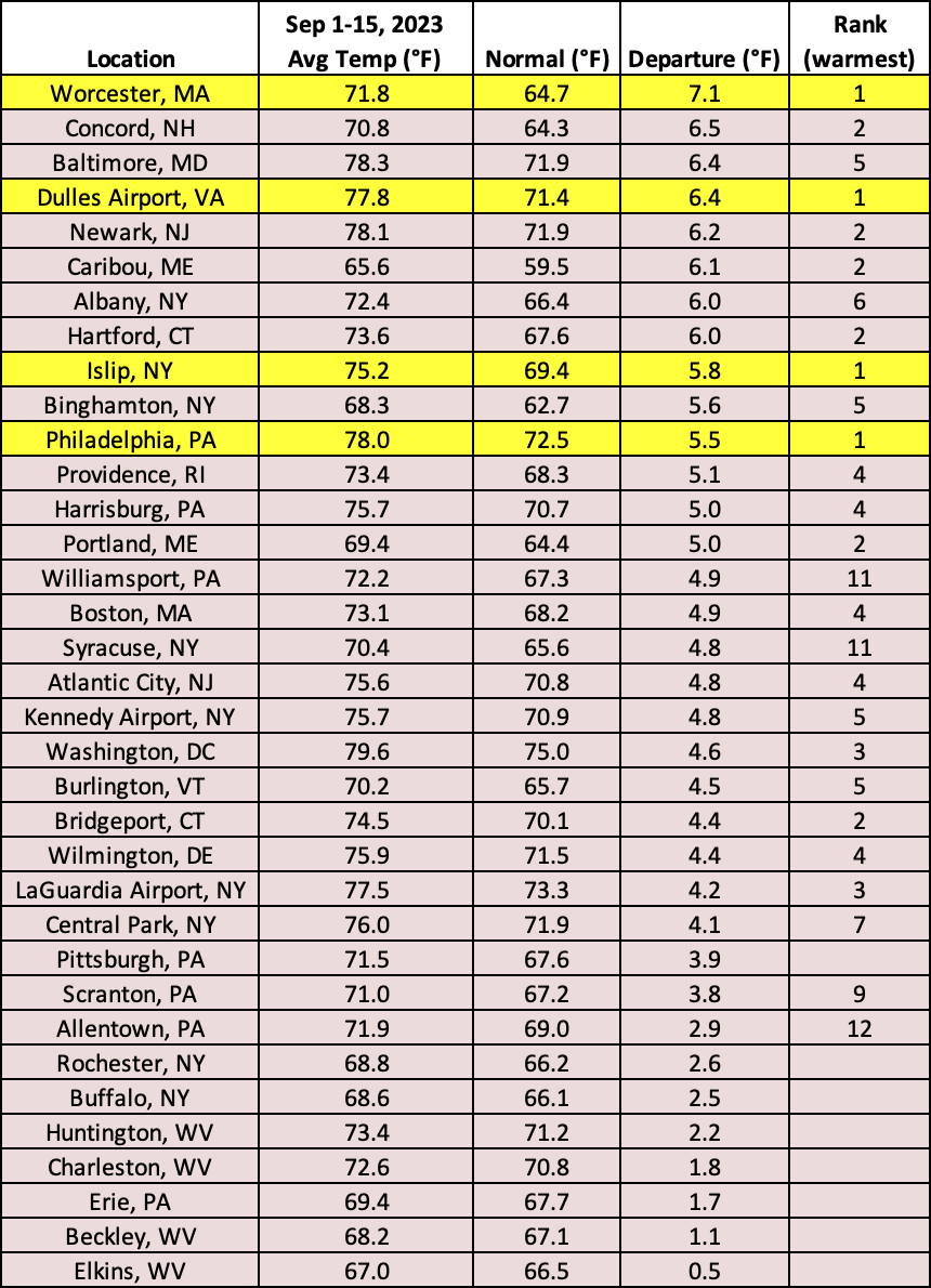
This September 1-15 period was record warm for three major climate sites and among the 10 warmest for another 20 of the sites.
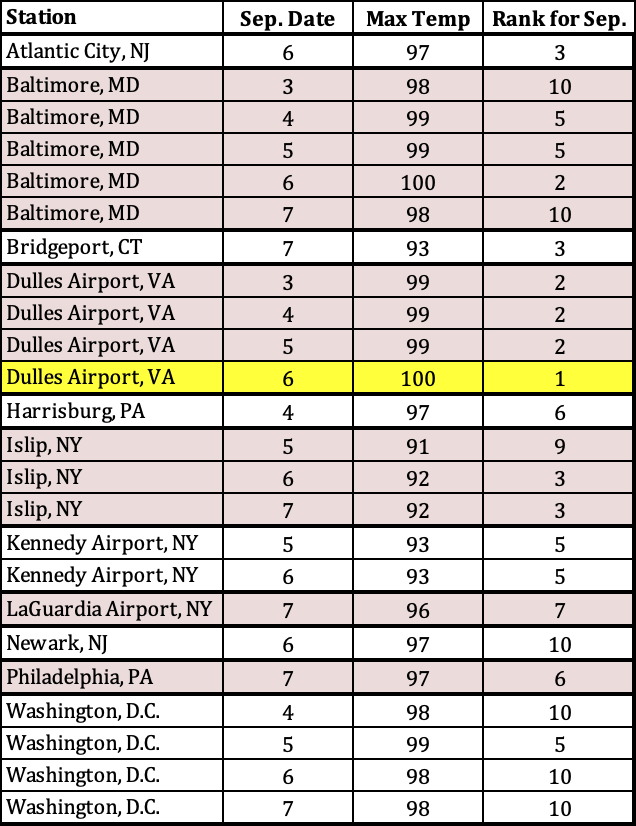
High temperatures were among the 10 warmest on record for September at several sites including Dulles Airport, VA, which had its hottest September temperature.
The warmth was primarily driven been an unusually mild first week or so of September when high temperatures ranged from 80°F to 100°F and low temperatures were in the 60s and 70s. During this time, Dulles Airport, VA, hit 100°F, its hottest September temperature on record, while Islip, NY, and Caribou, ME, had record warm low temperatures for September with 77°F and 67°F, respectively. For several other sites, their high and/or low temperatures ranked among the 10 warmest for September. In fact, some sites saw multiple days reach that milestone. For instance, Baltimore, MD, which has records back to 1872, saw five days during this event that ranked among the 10 warmest high temperatures for September. Similarly, Worcester, MA, which has records back to 1892, saw three days during this event that ranked among the four warmest low temperatures for September.
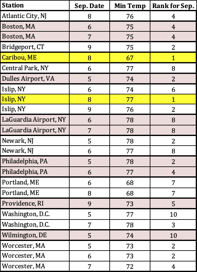
Low temperatures were among the 10 warmest on record for September at several sites including Islip, NY, and Caribou, ME, which had their warmest September low temperatures.
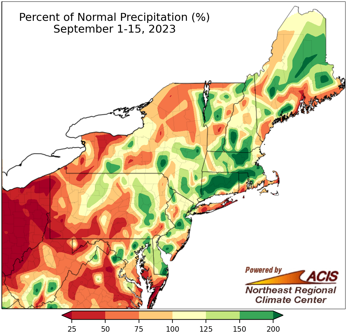
September 1-15 rainfall ranged from less than 25% of normal to more than 200% of normal.
Precipitation during the first half of September was highly variable, ranging from less than 25% of normal in western West Virginia and western Pennsylvania to more than 200% of normal in multiple spots including southeastern West Virginia and central Massachusetts. Nineteen of the 35 major climate sites were wetter than normal, with six ranking this first half of September among their 20 wettest on record. Overall, precipitation at the sites ranged from 24% of normal in Huntington, WV, to 235% of normal in Beckley, WV.
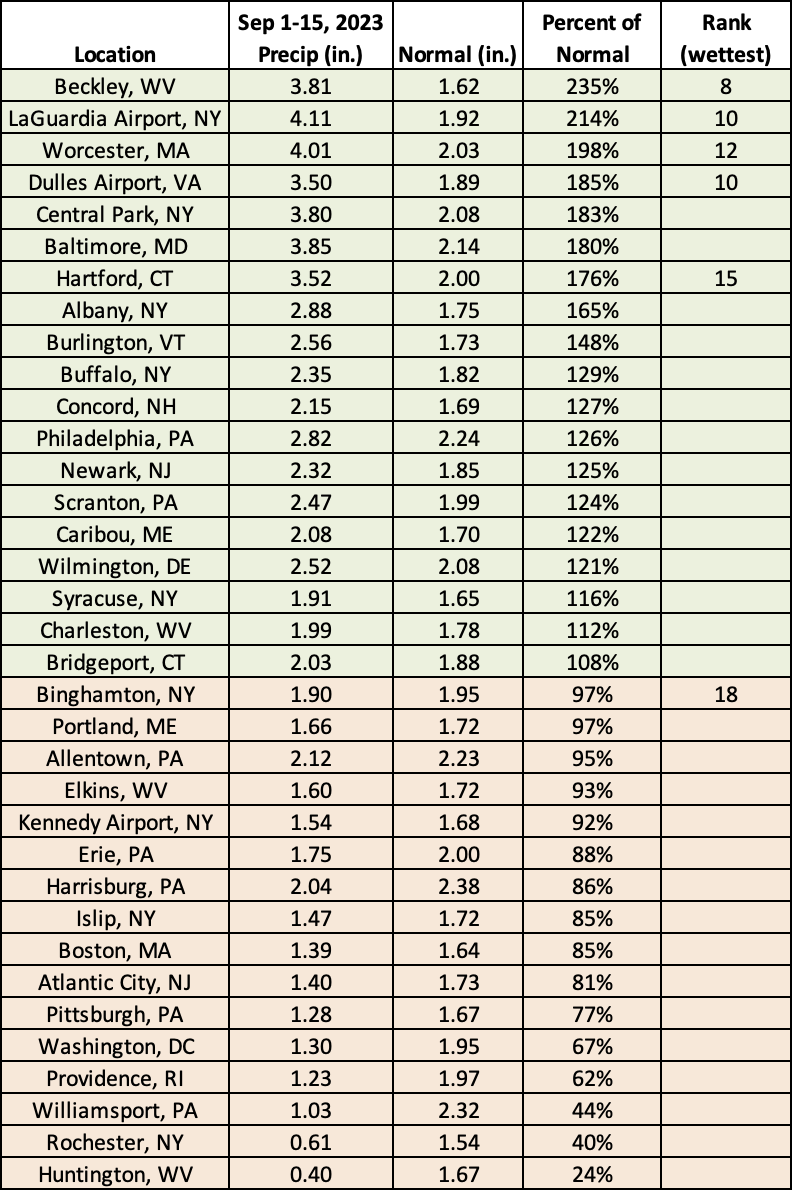
This September 1-15 period ranked among the 20 wettest on record for six major climate sites.
Warmer-than-normal temperatures are expected to continue through the rest of the month and into early October, according to NOAA’s Climate Prediction Center. The 8-14 day outlook, which runs from September 26 through October 2, calls for an increased likelihood of above-normal temperatures for the entire Northeast. The precipitation outlook for the same period shows a tilt toward wetter-than-normal weather for an area from West Virginia to southern New England, with near-normal precipitation expected for the rest of the region. The full October outlook from the Climate Prediction Center will be released on Thursday, September 21.
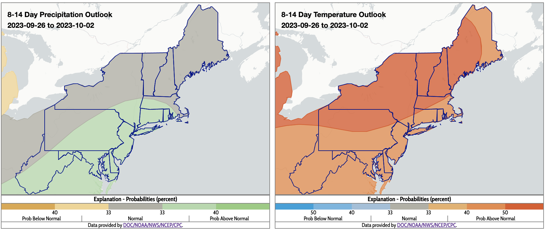
The rest of September is expected to be warmer than normal for all, with near- or above-normal precipitation.