Historic Tropical Depression Ida
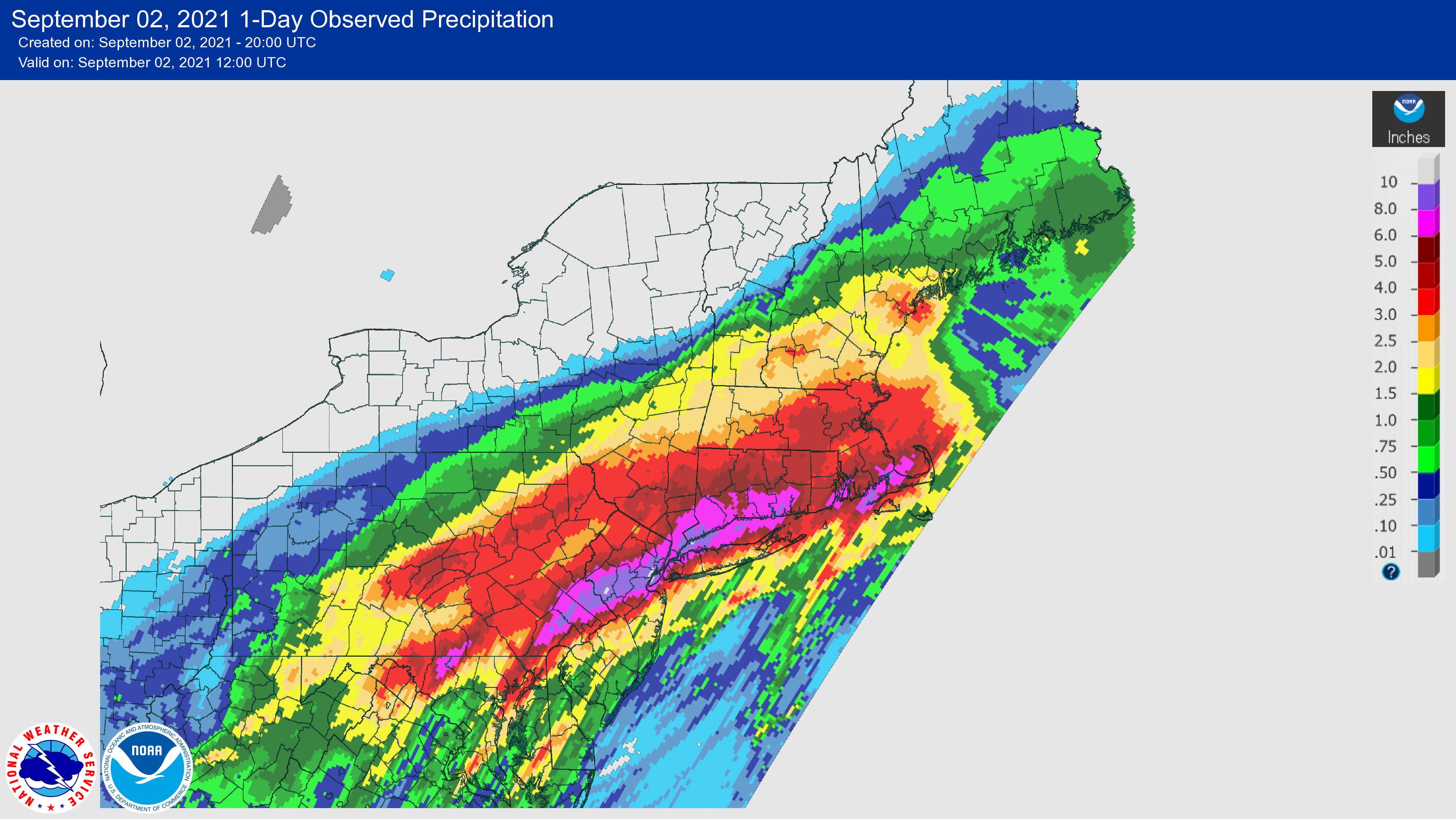
Daily rainfall totals from Tropical Depression Ida, with the dark purple areas seeing at least 8 inches of rain. Click to enlarge.
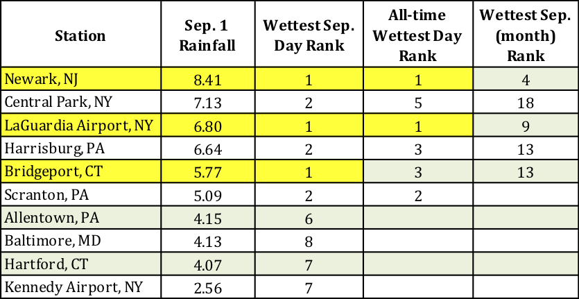
Tropical Depression Ida dropped catastrophic amounts of rain on parts of the Northeast on September 1. A swath of the region stretching from eastern Pennsylvania and northern/central New Jersey through the New York City metro area and into southern New England saw rainfall totals of more than 6 inches. In fact, a corridor of 8- to 11-inch rainfall totals were found in southeastern Pennsylvania, northern/central New Jersey, and the New York City area. Newark, NJ, saw 8.41 inches of rain, making it the site’s all-time wettest day on record and already making September 2021 the site’s fourth wettest September on record. LaGuardia Airport, NY, also recorded its all-time wettest day with 6.80 inches of rain. Meanwhile, Bridgeport, CT, which saw 5.77 inches of rain, experienced its wettest September day.
Newark, NJ, and LaGuardia Airport, NY, had their all-time wettest day on record, while Bridgeport, CT, saw its wettest September day.
Rain fell at a rate of 3 to 5 inches per hour in some locations, with the bulk of the daily rainfall accumulating within a six-hour period in most areas. Newark, NJ, recorded its all-time wettest hour on record, seeing 3.24 inches of rain between 8 and 9 pm. The site’s one-hour rainfall, two-hour rainfall total of 5.06 inches, and six-hour total of 7.88 inches all qualified as 500-year storm events, meaning they have a 0.2% chance of happening in a given year. Similarly, Central Park, NY, had its all-time wettest hour on record with 3.15 inches of rain from 9 to 10 pm. That record had just been set less than two weeks prior from Tropical Storm Henri. Central Park’s two-hour rainfall of 4.65 inches and six-hour total of 6.63 inches also both qualified as 500-year storm events.
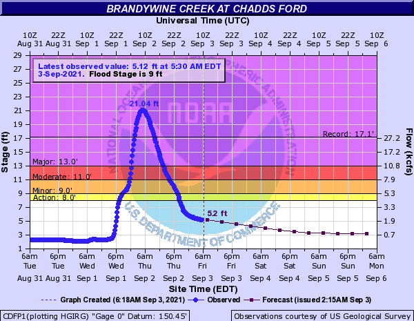
Several waterways reached their all-time highest water levels on record, including the Brandywine Creek at Chadds Ford, PA.
Many of these locations had just seen excessive rainfall from tropical systems Fred and Henri a few weeks prior. With saturated soils, waterways already running high, and the deluge from Ida, dozens of streamgages reached major flood stage, a water level high enough that “extensive inundation of structures and roads” and “significant evacuations” are possible.
In fact, water levels reached historic levels at several long-term sites. For example, Brandywine Creek at Chadds Ford, PA, which has records to the early 1900s, reached 21.04 feet, approaching the operational limit of the gage and beating the previous record of 17.15 feet from September 17, 1999. Similarly, the Raritan River at Manville, NJ, which also has records back to the early 1900s, reached a new record high water level of 27.66 feet. In addition, several more long-term sites reached near-record water levels. The Schuylkill River at Philadelphia, PA, reached 16.35 feet, its second highest crest on record and just below the all-time highest water level of 17.0 feet set back on October 4, 1869.

Photos comparing Neshaminy Creek at Langhorne, PA, before and during major flooding. Click to enlarge.
A rare Flash Flood Emergency, issued only when a significant threat to human life and property is happening or imminent, was declared in portions of southeastern Pennsylvania, northern/central New Jersey, and New York City. In fact, the New York National Weather Service office issued a Flash Flood Emergency for the first time ever, in northern New Jersey, then declared another one for New York City, the first time the city has been under such a warning.
Devastating flooding occurred in multiple locations. Numerous roads were impassable, including portions of major highways such as the Vine Street Expressway through downtown Philadelphia and FDR Drive, a major thoroughfare along the east side of New York City. Countless vehicles were stranded and several people were swept away in rising waters across the region, including at least three instances of school buses getting stuck. Public transportation around the New York City metro area ground to a halt, stranding thousands. Floodwaters poured into New York City’s subway system, with more than people 800 passengers rescued, buses and above-ground trains were stranded, and lower levels of Newark International Airport took on water. Numerous structures, including homes and apartments, were inundated by floodwaters, resulting in several deaths. Between flooded roads and buildings, hundreds of water rescues were performed, with the Philadelphia National Weather Service office noting that “crews are running out of resources to rescue people stuck in flood waters.” Some residents were advised to shelter in place. However, in a few areas, there were concerns that dams would be overtopped, resulting in thousands of people being evacuated. As of publishing, there had been at least 48 deaths in the Northeast, at least 25 of those in New Jersey and at least 13 of those in New York City, due to Ida.
Red dots indicate where tornadoes touched down in the Northeast.
Ida also produced at least 11 tornadoes, with the most in Pennsylvania. The strongest tornado, a rare EF-3 with winds of up to 150 mph, carved a 12.6-mile path of destruction through southern New Jersey. The tornado caused significant strutural damage to dozens of homes, leaving some inhabitable, tossed vehicles, and destroyed barns and outbuildings. Two EF-2 tornadoes, one in Montgomery County, PA, and another in Annapolis, MD, damaged buildings and caused considerable tree damage. In addition, straight-line winds of up to 80 mph caused damage in southeastern Massachusetts.
Please note that the information above is preliminary and may change as more data becomes available over the next few days. Fred, Henri, and Ida pummeled the Northeast near the 10th anniversary of Tropical Storms Irene and Lee, which produced devastating flooding across parts of the Northeast in August and September 2011.