Flip-Flop
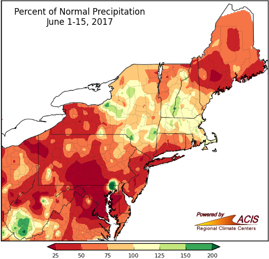
June 1-15 precipitation ranged from less than 25% of normal to more than 150% of normal, with many areas on the dry side of normal.
Caribou, ME, and Washington National, DC, had their driest first half of June on record. During that time, Washington, DC, did not see measurable rainfall (0.01"). In fact, the first half of June was drier than normal for a large portion of the Northeast. The driest areas, receiving less than 25% of normal precipitation, were generally in northern West Virginia and the state’s Eastern Panhandle, much of Maryland, northwestern and south-central Pennsylvania, and portions of Maine. Twenty-seven of the 35 major climate sites were drier-than-normal, with 15 of those ranking this first half of June among their top 20 driest. The wettest area was southern West Virginia, which received over 150% of normal rainfall. For Beckley, WV, it was the fourth wettest first half of June on record. Please note that this June 1-15 summary does not include the heavy precipitation that fell across portions of West Virginia, Pennsylvania, and New York during the day on June 15 (which will be reported on June 16).
While the Northeast remains free of drought, abnormal dryness was introduced in western West Virginia in the U.S. Drought Monitor released on June 15.
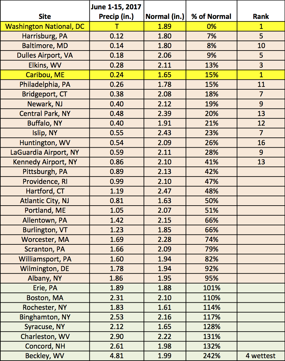
June 1-15 rainfall at the major climate sites ranged from 0% of normal at Washington National, DC, to 242% of normal in Beckley, WV. Washington National, DC, and Caribou, ME, were record dry for the period.
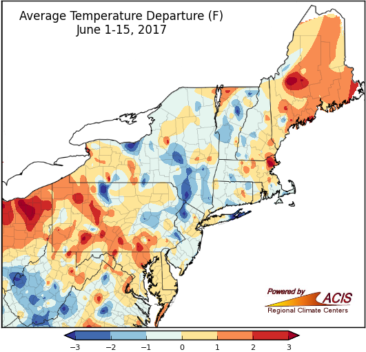
June 1-15 average temperatures ranged from 3°F below normal to 3°F above normal, with many areas within 1°F of normal.
During the first half of June, temperatures went from well below normal to well above normal. June 6 was particularly cool, with high temperatures as much as 25°F below normal. At six major climate sites, the high temperatures on June 6 ranked among the top five coldest for summer. A week later, from June 11 to 14, high temperatures soared into the 90s (°F) and above in parts of the region. LaGuardia Airport, NY, had a high of 101°F on June 13, tying its warmest June temperature on record.
With that, average temperatures during the first two weeks of June were within 1°F of normal for a large portion of the region. There were a few cooler spots, mainly in West Virginia and New York, as well as a few warmer spots, mainly in Pennsylvania and Maine. Twenty-three major climate sites were also within 1°F of normal, with two ranking this first half of June as their 13th warmest on record.
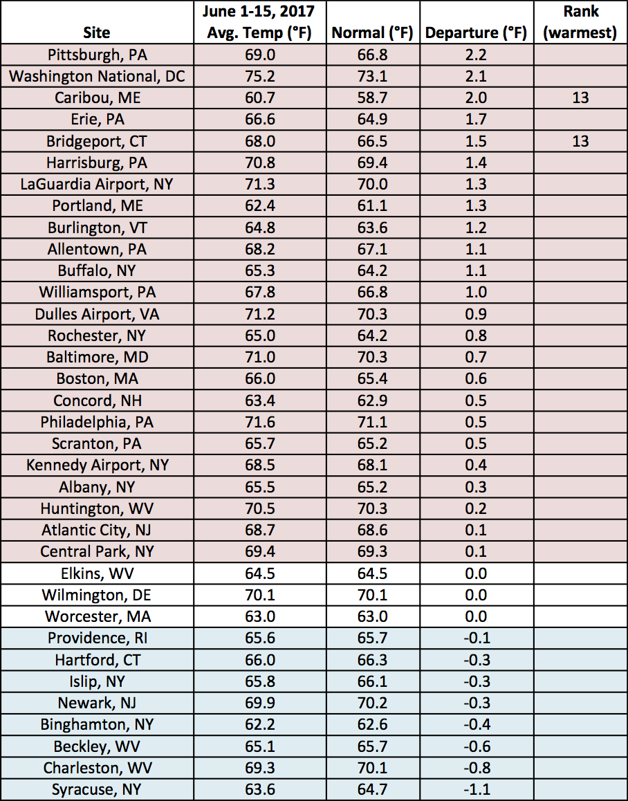
June 1-15 average temperatures at the major climate sites ranged from 1.1°F below normal in Syracuse, NY, to 2.2°F above normal in Pittsburgh, PA.