Another Record-Setting September
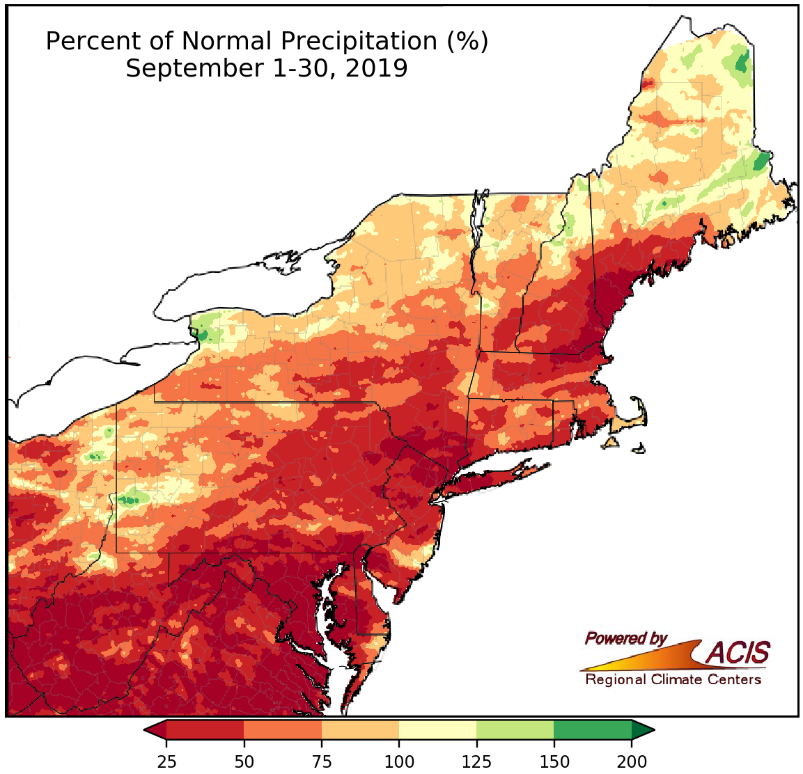
September precipitation ranged from less than 25% of normal to near normal for a majority of the Northeast.
September was an exceptionally dry month for portions of the Northeast. Let’s look at some stats.
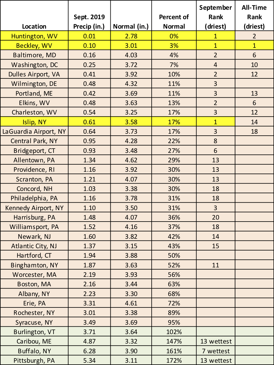
- 0.10" - That's all the rainfall that Beckley, WV, received in September, making it the site's all-time driest month on record.
- 33 - The record-setting streak of consecutive days with less than or equal to 0.01" of precipitation in Huntington, WV, from August 28 through September 30, 2019. The site wrapped up September with only 0.01" of precipitation, ranking as the driest September on record and the second all-time driest month on record (behind October 1963 with a trace). Side note - both Beckley and Huntington had their wettest September on record just last year!
- 0.61" - Islip, NY's September precipitation total, qualifying it as the driest September on record.
- 23 - The number of (the 35) major climate sites that received less than half their normal September precipitation. In fact, a dozen sites received less than a quater of their normal September precipitation.
- 10 - That's how many major climate sites ranked this September among their 20 all-time driest months on record. The month ranked among the 20 driest Septembers on record for 24 major climate sites.
With ballooning precipitation deficits and above-normal temperatures, abnormal dryness and moderate drought expanded to include a large portion of the Northeast. The U.S. Drought Monitor released on September 26 showed 43% of the region was abnormally dry and 7% was in a moderate drought. Impacts of dryness included an early start to the fire season, dry soil, stunted growth and declining quality of some crops, diminishing water supplies and streamflows, and muted colors of fall foliage. You can keep up to date on drought conditions by following our weekly drought update as well as checking out our Northeast Drought Early Warning System Dashboard.
Huntington and Beckley, WV, and Islip, NY, had their driest September on record. In fact, it was Beckley’s all-time driest month on record.
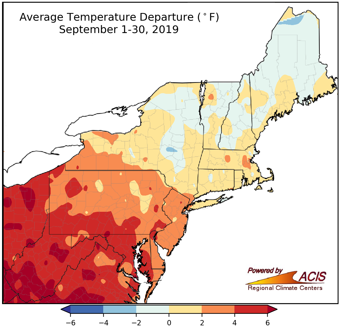
September average temperatures ranged from 2°F below normal to more than 6°F above normal.
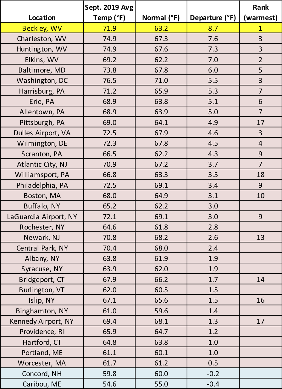
September was a warmer-than-normal month for many parts of the Northeast, with average temperatures ranging from within 2°F of normal in most of New York and New England to more 6°F above normal in West Virginia. Beckley, WV’s average temperature of 71.9°F was hotter than the site’s normal July average temperature (70.6°F) and ranked as the hottest September on record. Another 21 major climate sites ranked this September among their 20 warmest on record.
Neither Beckley nor Elkins, WV, had a day this September that was colder than normal. Additionally, Elkins had its highest average max temperature for September, and both Elkins and Huntington, WV, had their greatest number of September days with a high of at least 80°F with 23 days and 29 days, respectively.
For 16 major climate sites this September ranked among the 10 warmest on record, with Beckley, WV, having its hottest September.
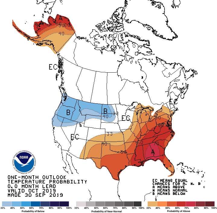
October looks to potentially bring more of the same to some areas. The Climate Prediction Center favors above-normal temperatures for much of the Northeast except northeastern New York and parts of New England (where equal chances were predicted). The place with the greatest likelihood for above-normal temperatures? You guessed it - West Virginia!
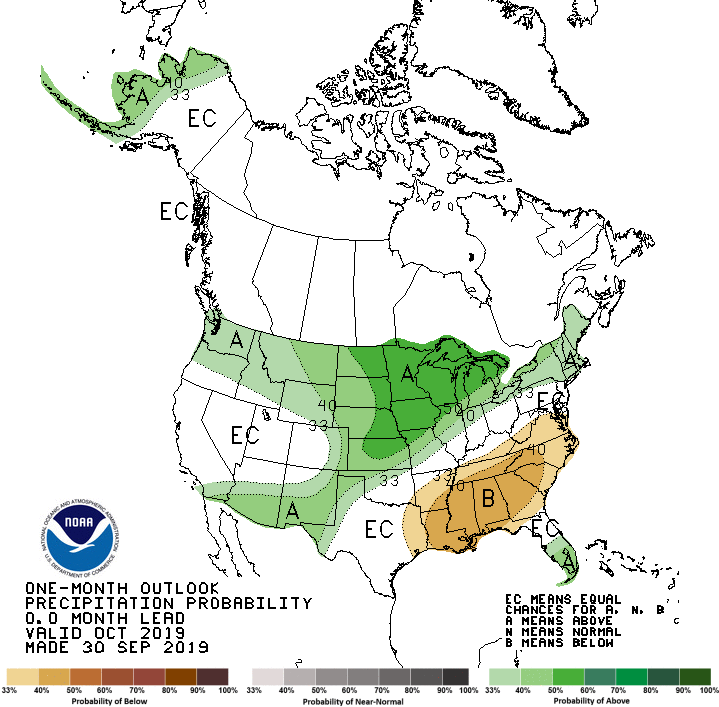
Drought conditions could linger, or potentially worsen, in West Virginia as the Climate Prediction Center outlook indicates a tilt towards a drier-than-normal October for that state as well as portions of Maryland. On the other hand, above-normal precipitation is predicted for northern Pennsylvania, New York, and New England, with equal chances elsewhere in the region.
October is expected to be warmer than normal for a large portion of the Northeast.
Below-normal October precipitation is predicted for areas shaded tan, while above-normal precipitation is favored for areas shaded green.

