July - To the Extreme
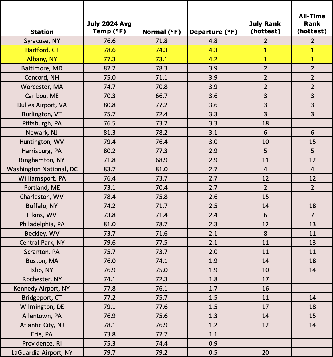
This July was the all-time hottest month on record for Hartford, CT, and Albany, NY, and among the 20 all-time hottest for another 26 major climate sites.
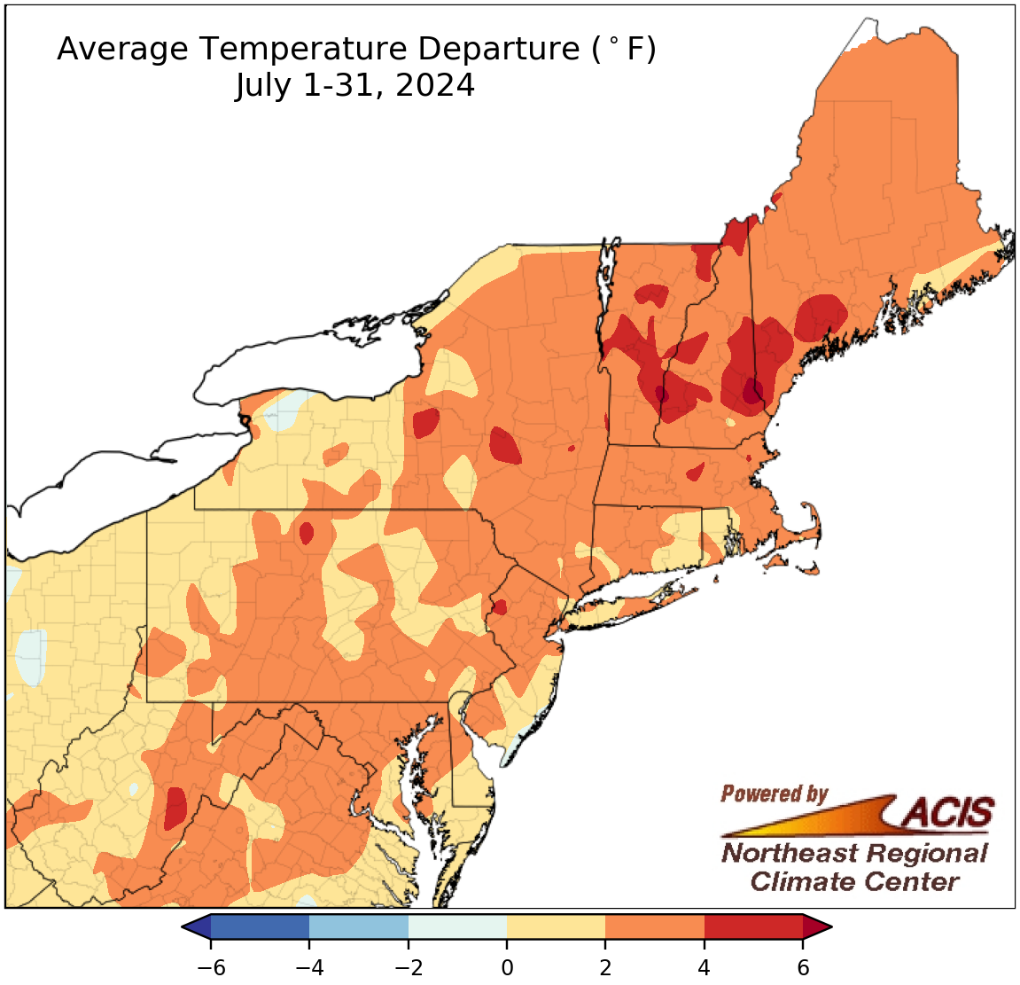
July was a temperature overachiever. Not only did this July rank among the 20 hottest Julys on record for 33 of the Northeast’s 35 major climate sites, it also ranked among the 20 all-time hottest months on record for 28 of the sites. In fact, Hartford, CT, and Albany, NY, experienced their hottest month ever recorded back to 1905 and 1874, respectively. July average temperatures at the major climate sites ranged from 0.5°F above normal at LaGuardia Airport, NY, to 4.8°F above normal in Syracuse, NY. Looking at the region as a whole, July was another in a long string of warmer-than-normal months, with average temperatures generally ranging from near normal to 6°F above normal. Several other notable stats about July’s hot weather can be found in the NRCC’s extreme weather blog.
July average temperatures generally ranged from near normal to 6°F above normal.
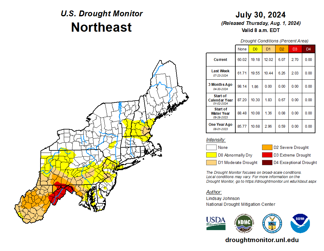
Extreme drought was introduced in the Mid-Atlantic this July, with severe and moderate drought also expanding in the region.
July featured opposite extremes of drought and excessive rainfall. Extreme drought was introduced in West Virginia and Maryland for the first time since September 2010, while the last time at least 1% of Pennsylvania was in extreme drought was October 2002. Severe and moderate drought also took hold in those states. The hot, dry weather resulted in a multitude of impacts including significant crop losses and increased operational costs. For more information on drought conditions in the Northeast, see the NRCC’s weekly drought update.
Meanwhile, extreme rainfall pummeled portions of northern New York and northern New England. The remnants of Beryl caused extensive, damaging flash flooding, with a few Vermont waterways reaching one of their five highest levels on record. Lowville, NY, saw 6.02 inches of rain in a day, its all-time wettest day since its records began in 1891. Northeastern Vermont was the focus of an intense rain and flooding event on July 30 that may have produced the state’s greatest daily precipitation total for July and possibly the state’s second greatest daily precipitation total for any month - 8.41 inches in St. Johnsbury. That site accrued 17.73 inches in July, with preliminary data suggesting it is the second greatest total for July in Vermont.
Preliminary data suggests St. Johnsbury’s 8.41 inches of rain is the state’s greatest daily precipitation total for July.
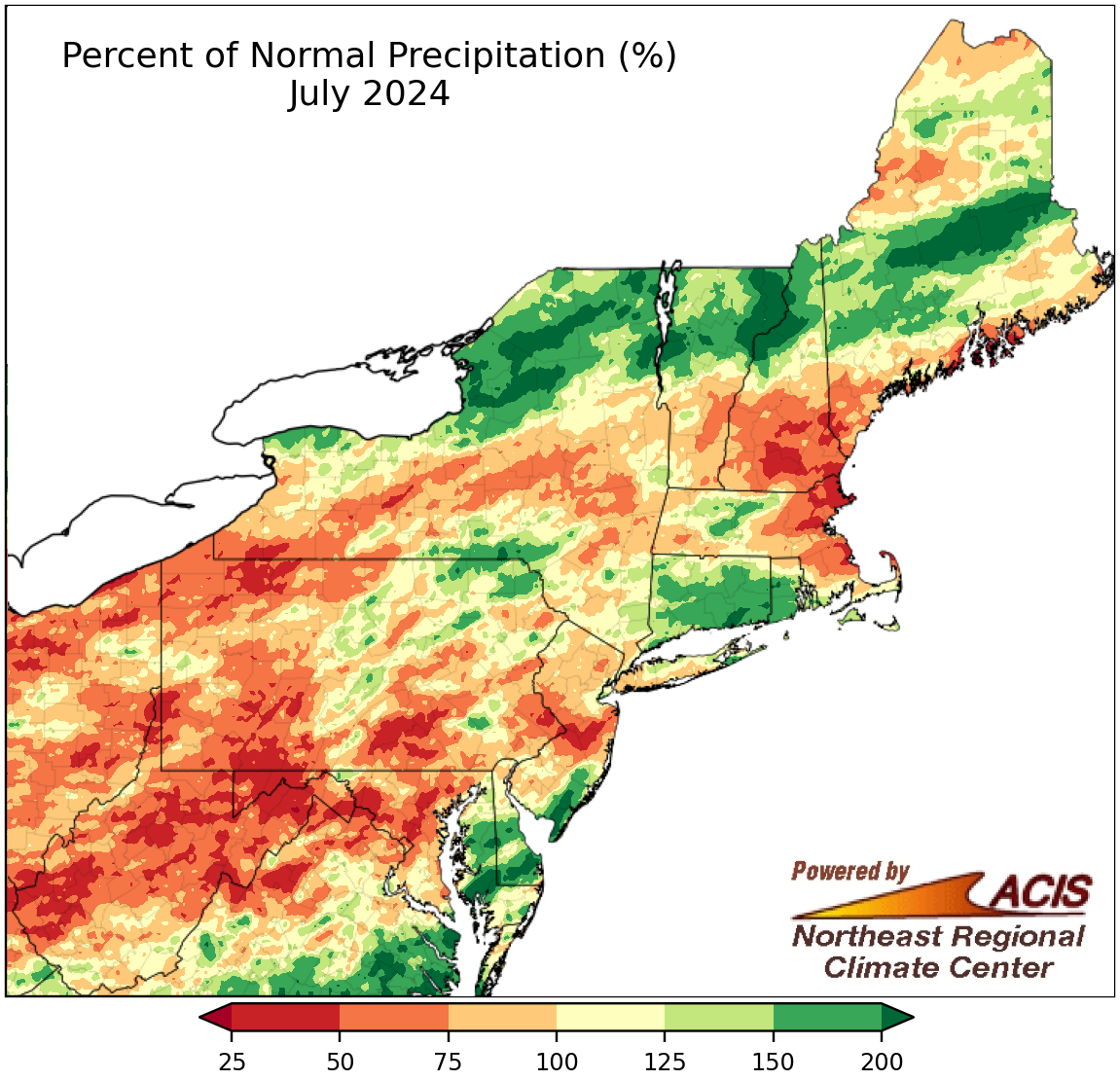
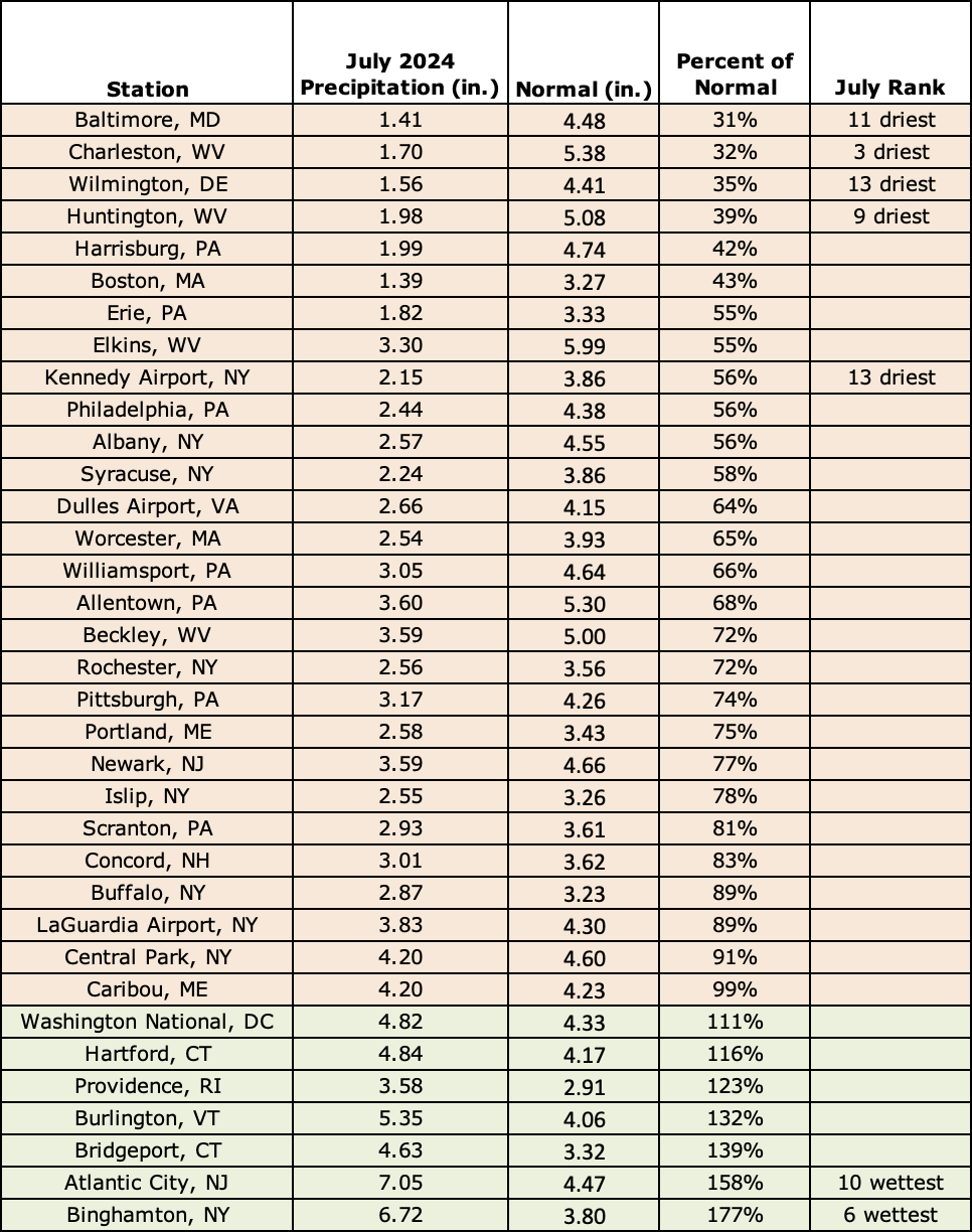
July precipitation ranged from 25% of normal to more than 200% of normal.
For the regional overview, July precipitation was highly variable, ranging from less than 50% of normal to more than 200% of normal. At the region’s 35 major climate sites, July precipitation ranged from 31% of normal in Baltimore, MD, to 177% of normal in Binghamton, NY, with 28 of the sites falling on the dry side of normal. This July ranked among the 13 driest Julys on record for five major climate sites but was among the 10 wettest for two other sites.
This July ranked among the 13 driest Julys on record for five major climate sites but was among the 10 wettest for two other sites.
And that’s not all! There were several rounds of severe weather during July that produced a preliminary 23 tornadoes in New York, likely the state’s greatest number for any month since records began in 1950. Plus, the Northeast saw hazy skies due to smoke from wildfires burning in the western U.S. and Canada. More information about everything in this blog will be available in the NRCC’s July summary to be released the first full week of August.
Whew! Moving on to August…
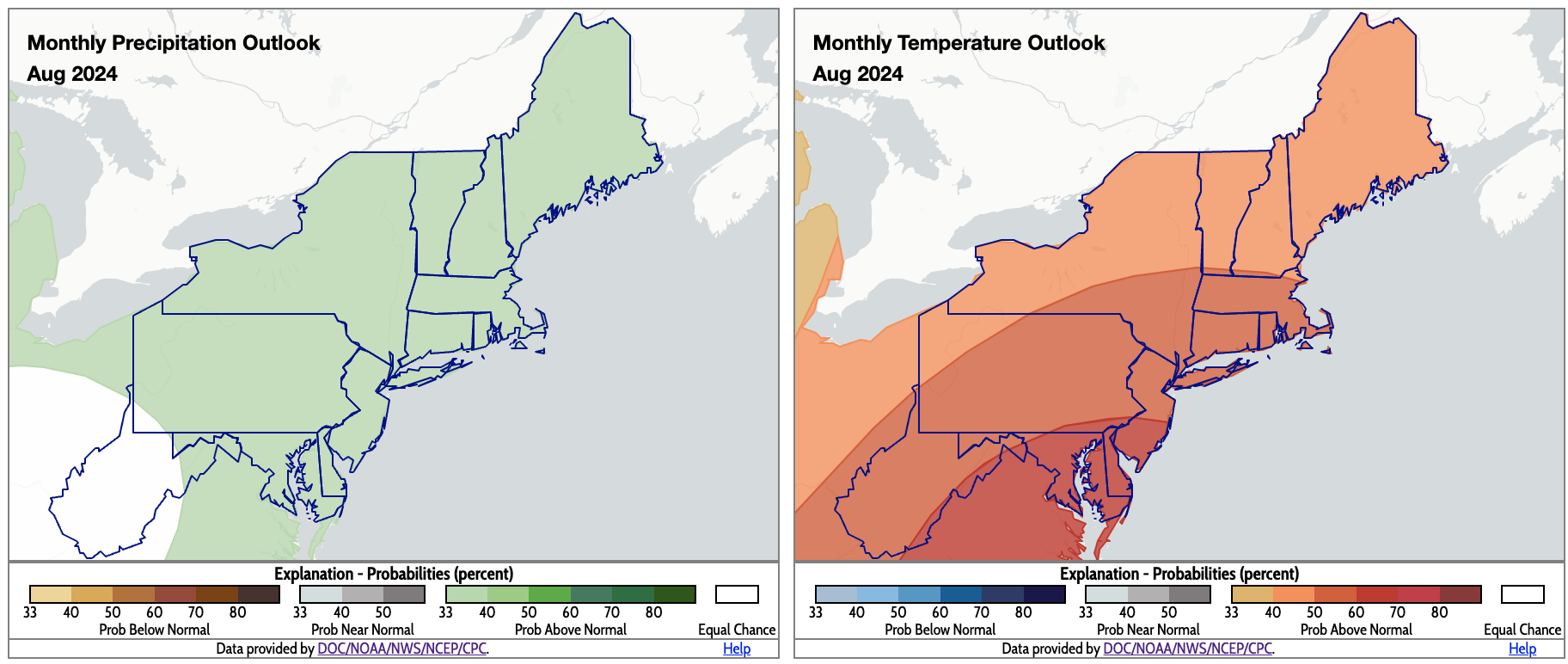
August is expected to be wetter and warmer than normal for much of the Northeast. Click to enlarge.
According to NOAA’s Climate Prediction Center, there’s an increased likelihood of above-normal precipitation for most of the Northeast, with much of West Virginia and a sliver of southwestern Pennsylvania being the exceptions. Above-normal temperatures are favored for the entire Northeast, with the greatest chances in the region’s southeastern corner.

