A Warm, (Mostly) Wet Fall-to-Date
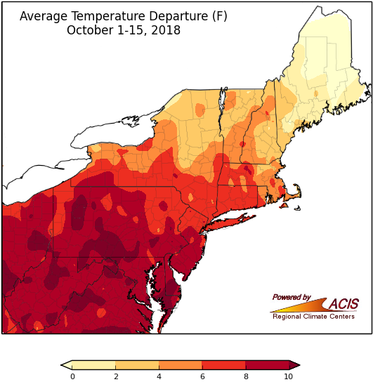
October 1-15 average temperatures ranged from near normal to more than 10°F above normal.
Following in the footsteps of September, the first half of October featured well-above-normal temperatures for a majority of the Northeast. Average temperatures ranged from near normal in northern Maine to more than 10°F above normal in parts of West Virginia, Pennsylvania, Maryland, and Delaware. It was the hottest first half of October on record for Allentown, PA; Atlantic City, NJ; and Dulles Airport, VA. Another 26 major climate sites ranked the period among their 20 warmest starts to October.
October 8 and 9 were particularly mild. Erie, PA, tied its all-time warmest October temperature on record with a high of 89°F. With low temperatures in the 70s on the 9th, Rochester, NY; Erie, PA; and Syracuse, NY, set/tied their all-time warmest minimum temperature records for October.
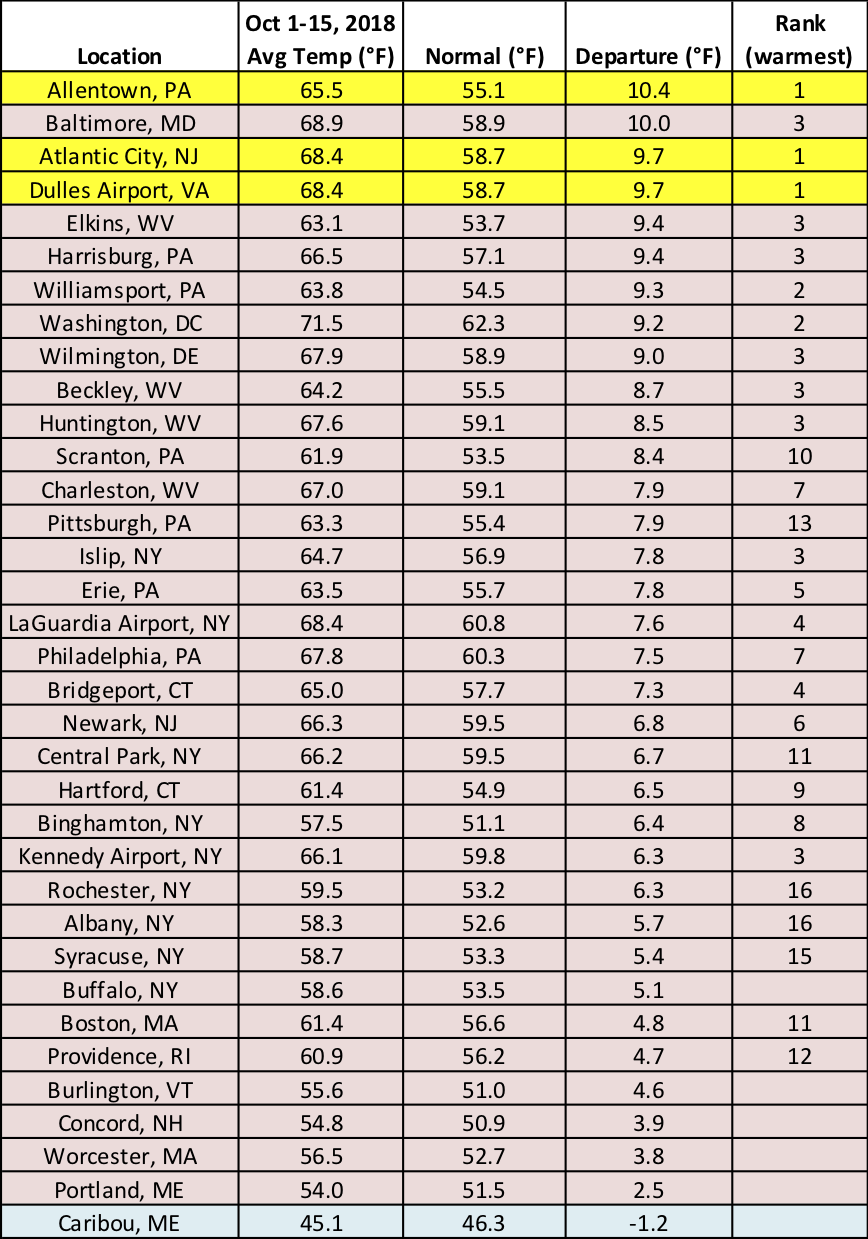
Allentown, PA; Atlantic City, NJ; and Dulles Airport, VA, had a record-warm start to October.
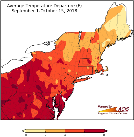
Average temperatures as of mid-fall ranged from near normal to more than 10°F above normal.
With both a mild September and warm start to October, fall-to-date average temperatures ranged from near normal in parts of Maine to more than 8°F above normal in parts of West Virginia, Pennsylvania, Maryland, and Delaware. Ten of the 35 major climate sites had their warmest first half of fall on record. Only three sites did not rank this first half of fall among their ten warmest on record.
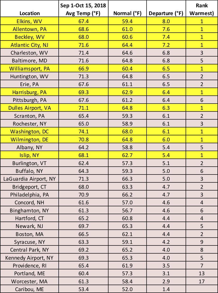
Ten major climate sites had a record-warm start to fall.
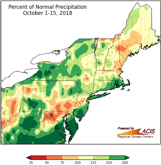
October-to-date precipitation generally ranged from 50% of normal to more than 200% of normal.
So far, October has been wetter than normal for a large portion of the Northeast. The wettest areas, which saw more than double normal precipitation, were in western New York, western Pennsylvania, parts of West Virginia, and some spots near the coast from southern Maryland to southern New England. Fourteen major climate sites ranked this first half of October among their 20 wettest on record. Conversely, the driest spots, with less than 75% of normal precipitation, were generally found in the Eastern Panhandle of West Virginia, northern Maryland, southeastern Pennsylvania, and parts of northern New England. Abnormal dryness and drought lingered in New York and northern New England.
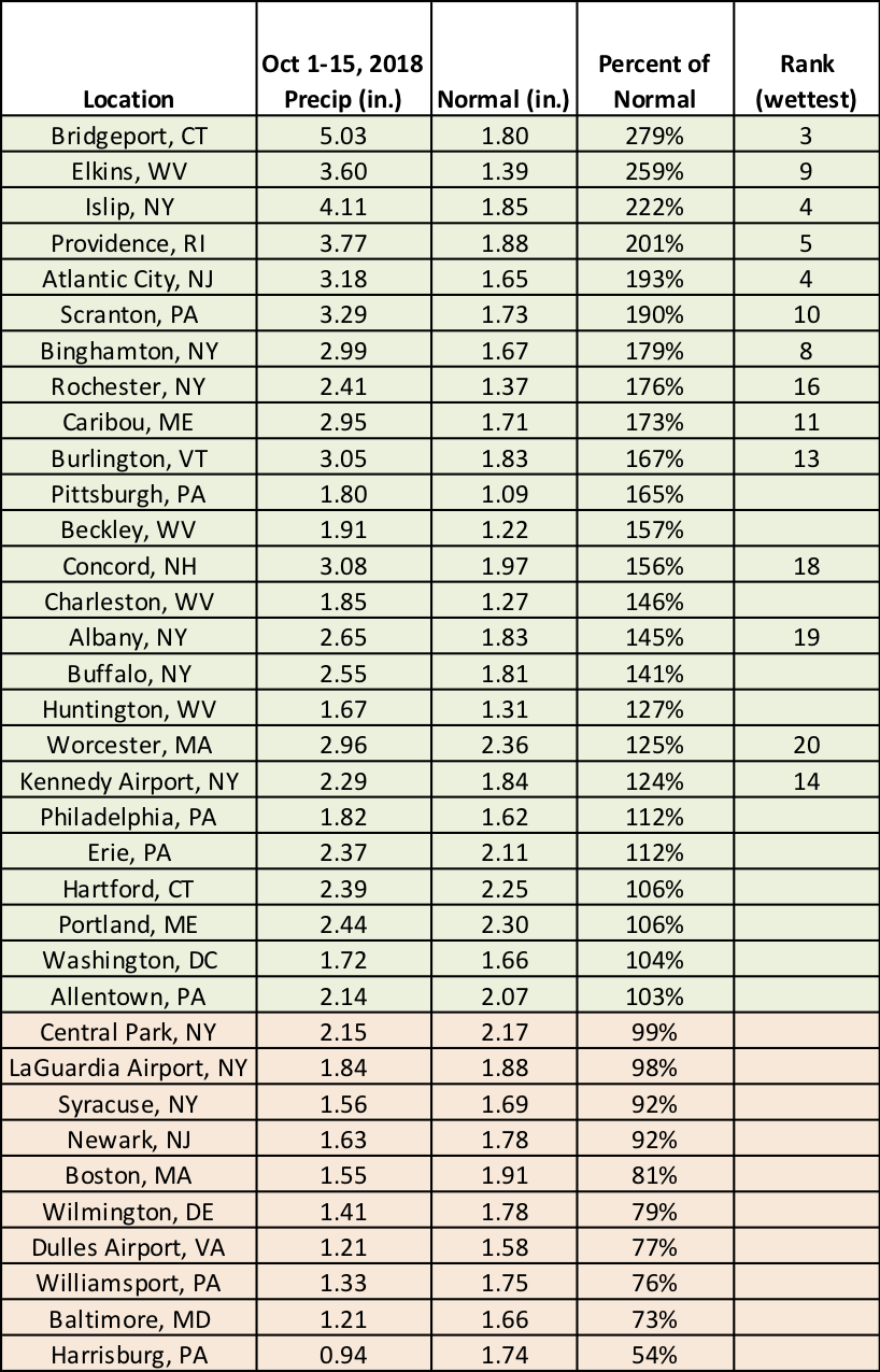
Fourteen major climate sites ranked this first half of October among their 20 wettest on record.
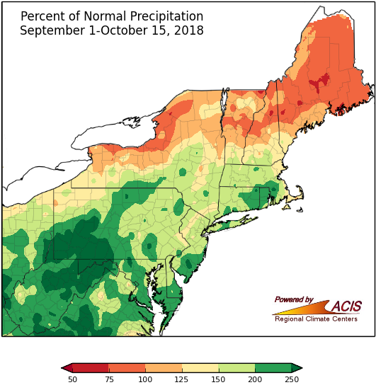
Precipitation as of mid-fall generally ranged from 75% of normal to more than 250% of normal.
With September and the first half of October being wetter than normal for many areas, mid-fall precipitation ranged from 75% of normal to more than 250% of normal. The line between wet and dry ran through New York and northern New England. Areas to the north tended to be drier than normal while areas to the south tended to be wetter than normal. In fact, ten major climate sites had their wettest first half of fall on record. Another 22 major climate sites ranked the period among their 20 wettest starts to fall.
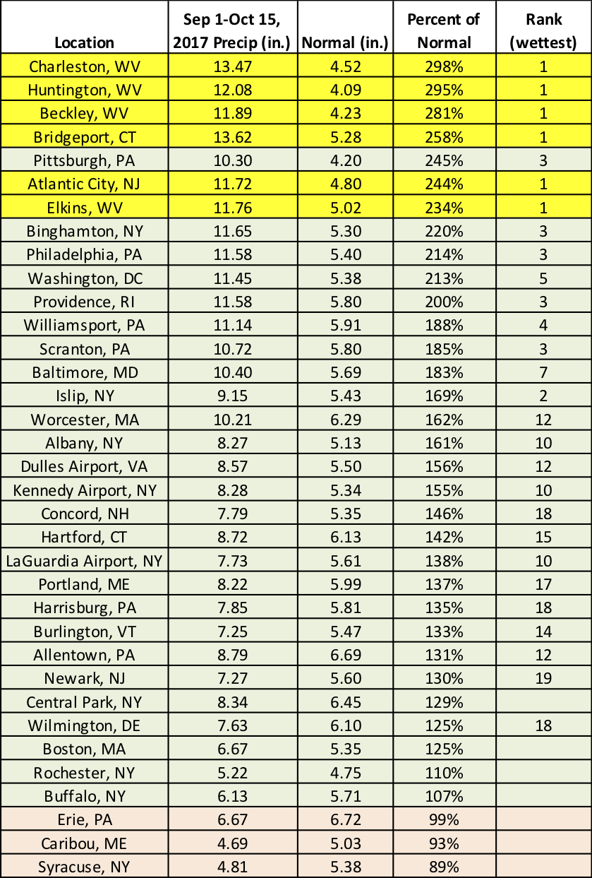
Six major climate sites had their wettest first half of fall on record.
It looks like conditions will flip to colder than normal for the rest of October. The Climate Prediction Center (CPC)'s temperature outlook for October 23-29 indicates an increased likelihood of below-normal temperatures for the entire Northeast. As for precipitation, CPC is predicting an increased chance of above-normal precipitation for parts of the Mid-Atlantic and West Virginia and near normal elsewhere.
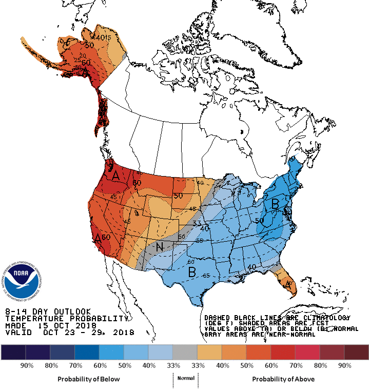
CPC’s temperature outlook indicates below-normal temperatures for the Northeast.
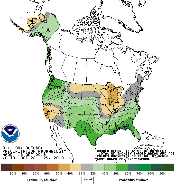
Near- to above normal precipitation is favored for October 23-29.