A Cold, Snowy Winter for Most
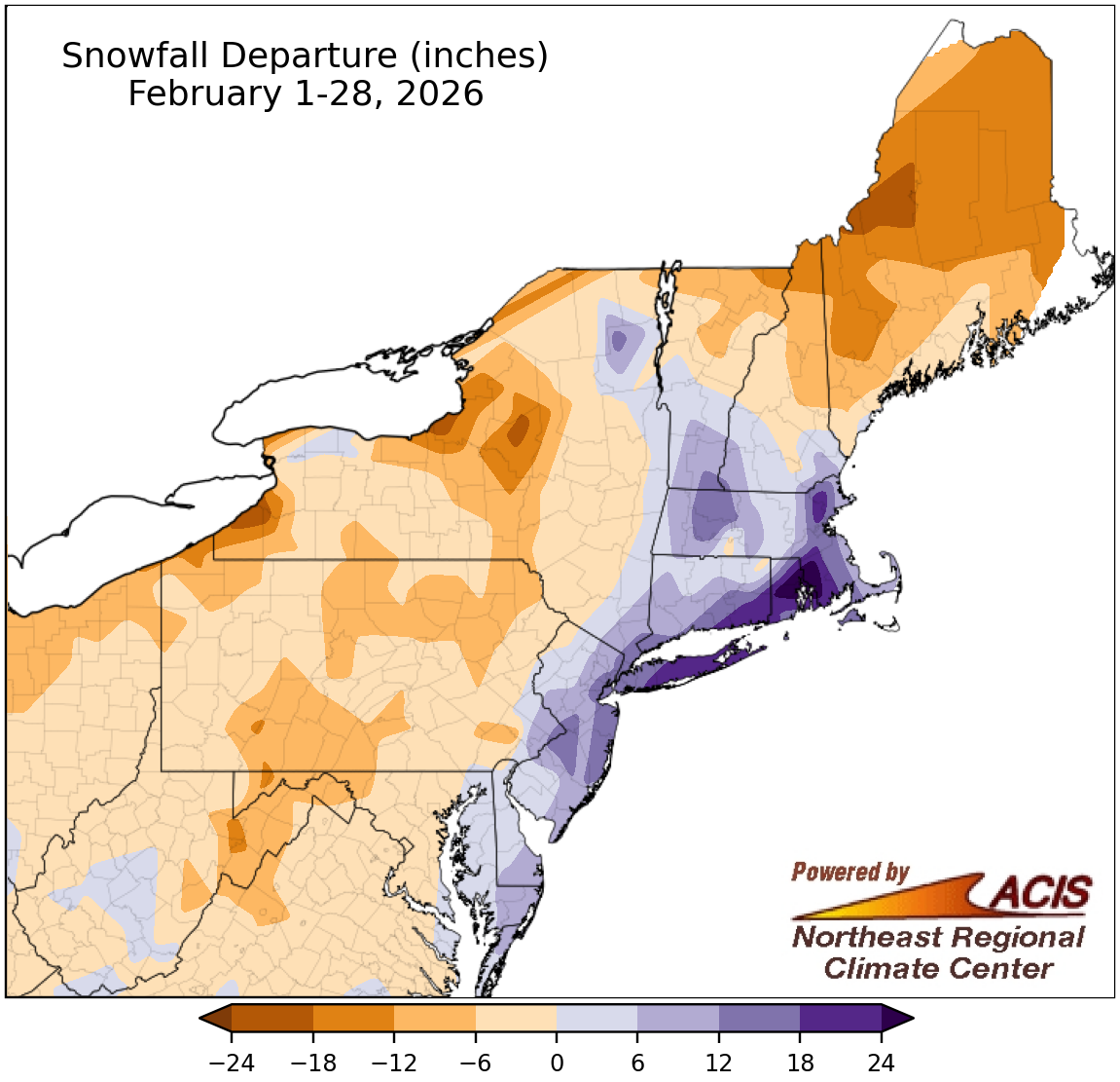
February snowfall ranged from 24 inches below normal to more than 24 inches above normal.
A record-setting blizzard hit coastal locations in late February, dropping 18 to 38 of snow along a path from Delaware to Massachusetts and giving a monthly snowfall surplus of 6 to over 24 inches in several areas. Overall, 17 of the Northeast’s 35 major sites reported above-normal February snowfall, ranging from 0.2 inches above normal in Charleston, WV, to 32.4 inches above normal in Providence, RI. This February was record-snowy for Providence, RI, and Islip, NY, and ranked among the 20 snowiest Februarys for another eight major sites. In fact, this February became the all-time snowiest month on record for Providence and ranked among the 20 all-time snowiest months for an additional six major sites.
However, much of the Northeast had below-normal snowfall this February, with deficits of up to 24 inches in western Maine and some lake-effect areas of New York. Eighteen of the 35 major sites saw below-normal February snowfall, ranging from 5.5 inches below normal in Caribou, ME, to 1.4 inches below normal in Buffalo, NY. This February ranked among the 20 least snowy Februarys for four major sites.
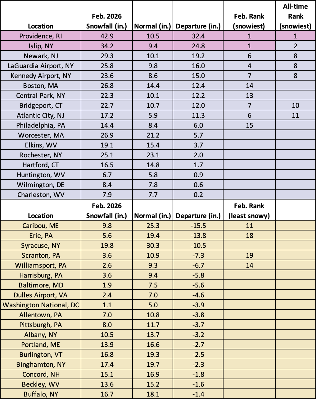
This February was the all-time snowiest month on record for Providence, RI, and the snowiest February for Islip, NY.
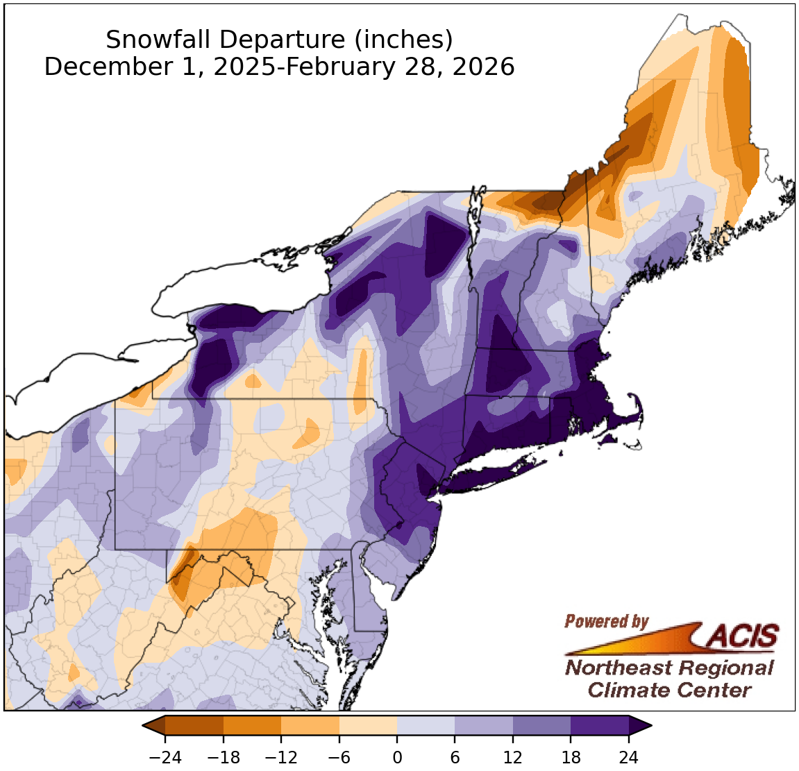
Winter snowfall ranged from 18 inches below normal to more than 24 inches above normal.
With near- to above-normal snowfall for most areas in December and January and a blizzard in February for some locations, winter snowfall ranged from 18 inches below normal in spots like northern Maine to more than 24 inches above normal in places like southern New England, parts of New York, and northeastern New Jersey. Winter snowfall at the region’s 35 major sites ranged from 17.2 inches below normal in Caribou, ME, to 40.1 inches above normal in Providence, RI, with 27 of the sites having a snowfall surplus. This winter was the snowiest winter on record for Providence, RI, and Islip, NY, and among the 20 snowiest for another 16 major sites. It was the first time since winter 2010-11 that Rochester, NY, had over 100 inches of snow.
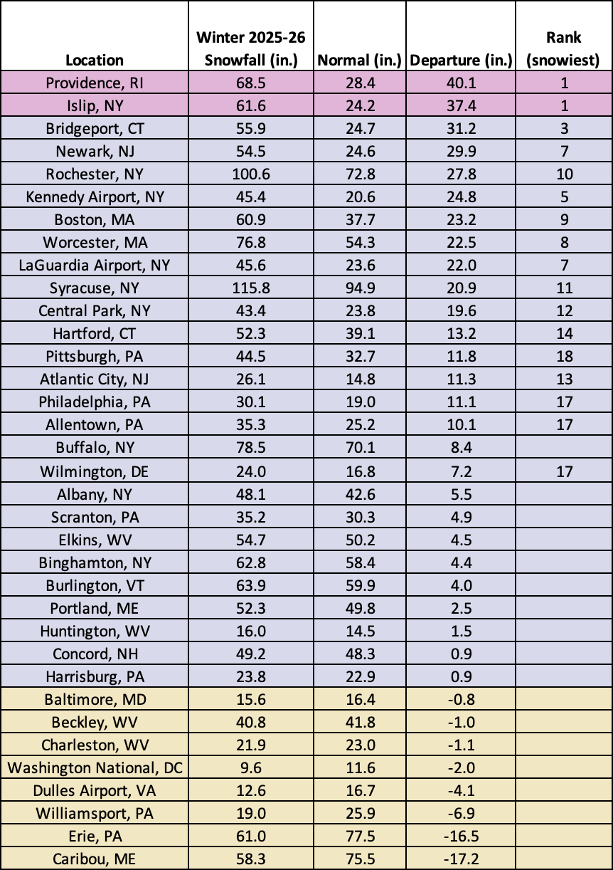
This winter was the snowiest winter on record for Providence, RI, and Islip, NY, and among the 20 snowiest for another 16 major sites.
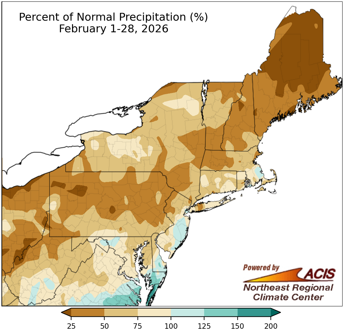
February precipitation ranged from less than 25% of normal to 150% of normal.
Almost the entire Northeast was drier than normal during February, with the driest locations such as parts of Maine seeing less than 25% of normal precipitation. However, a handful of southern and coastal areas eked out a wetter-than-normal February, seeing up to 150% of normal precipitation. February precipitation at the 35 major climate sites ranged from 27% of normal in Caribou, ME, to 111% of normal in Newark, NJ, with 31 of the sites being drier than normal. This February ranked among the 20 driest Februarys on record for 13 major sites (see note at bottom of February precipitation table below).
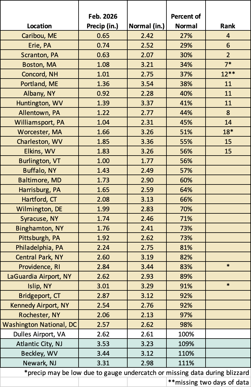
February 2026 ranked among the 20 driest Februarys on record for 13 major sites.
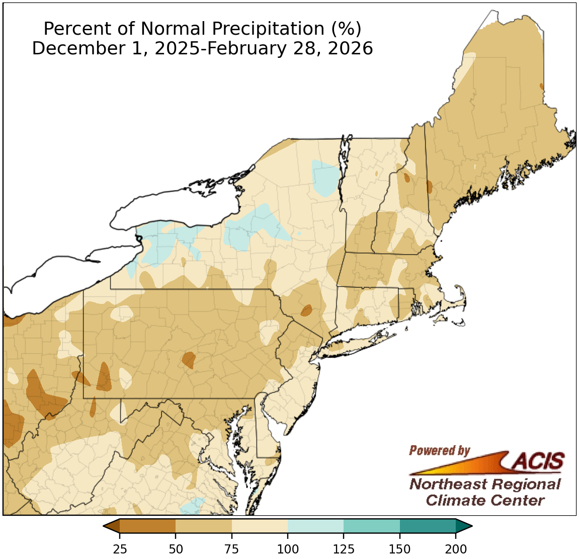
Winter precipitation generally ranged from 50% of normal to 125% of normal.
December and January also featured below- to near-normal precipitation for most areas, with a major exception being some lake-effect zones in New York. As such, winter precipitation ranged from 50% of normal to near normal for much of the Northeast, with some parts of New York seeing up to 125% of normal. At the region’s 35 major sites, winter precipitation ranged from 52% of normal in Boston, MA, to 115% of normal in Rochester and Syracuse, NY, the only wetter-than-normal major sites. This winter ranked among the 20 driest winters on record for 13 major sites. Please note that during the February blizzard, a few sites had missing data or less snow fell in the rain gauge due to very strong winds, resulting in lower precipitation totals (see winter precipitation table below).
The below-normal precipitation but above-normal snowfall was driven by the fact that high-pressure systems, with cold, sinking air, frequently settled over the Northeast this winter. This limited the number of storms moving through the region and overall precipitation totals. However, the cold air helped precipitation fall as snow and there were two major snowstorms this season.
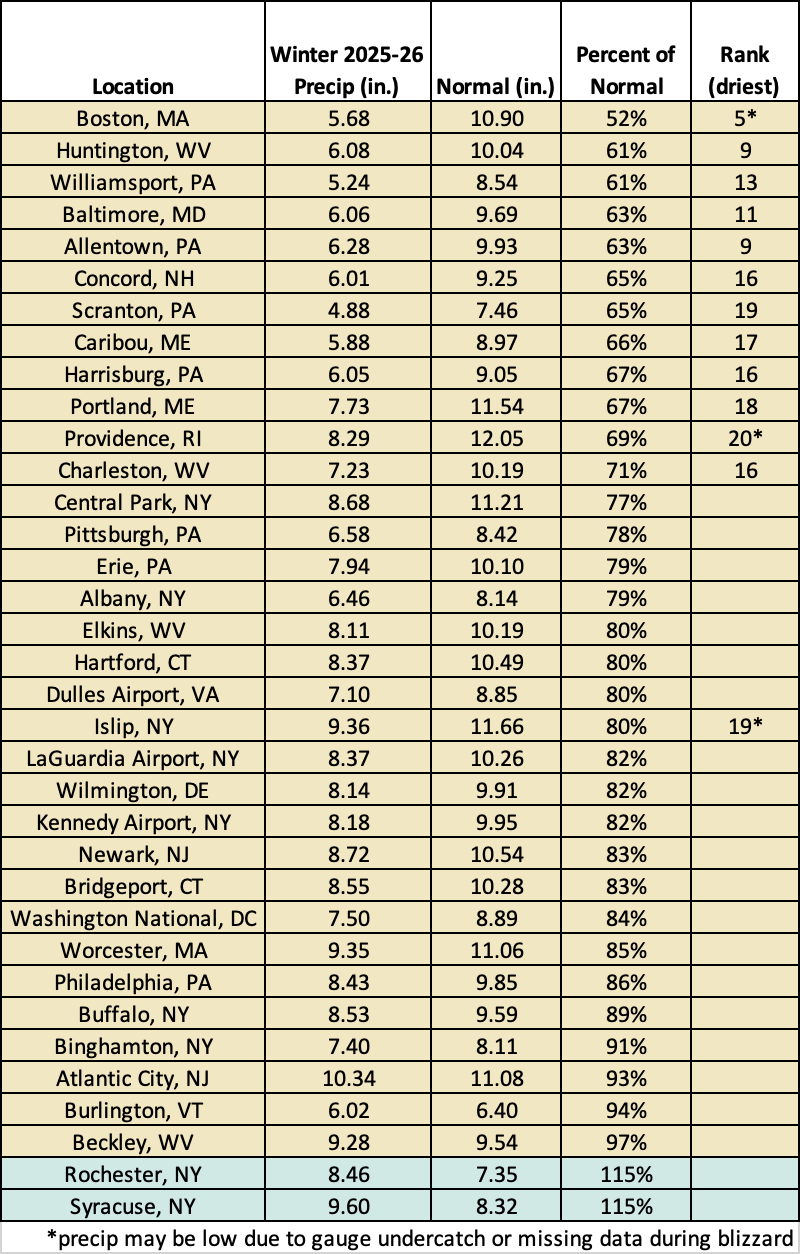
This winter was among the 20 driest winters on record for 13 major sites.
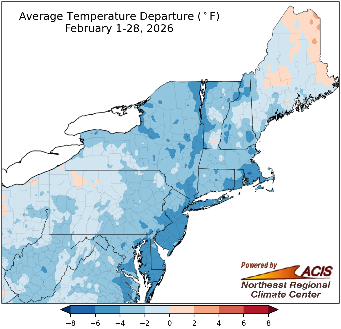
February average temperatures ranged from 6°F below normal to 2°F above normal.
Most of the Northeast experienced a colder-than-normal February, with average temperatures as much as 6°F below normal, particularly in coastal locations. However, parts of Maine were slightly warmer than normal. At the Northeast’s 35 major sites, February average temperatures ranged from 5.4°F below normal in Islip, NY, to 0.8°F above normal in Caribou, ME, the only warmer-than-normal major site. While this February only ranked among the 20 coldest Februarys on record for four major sites, it was the coldest February since 2015 for multiple sites.
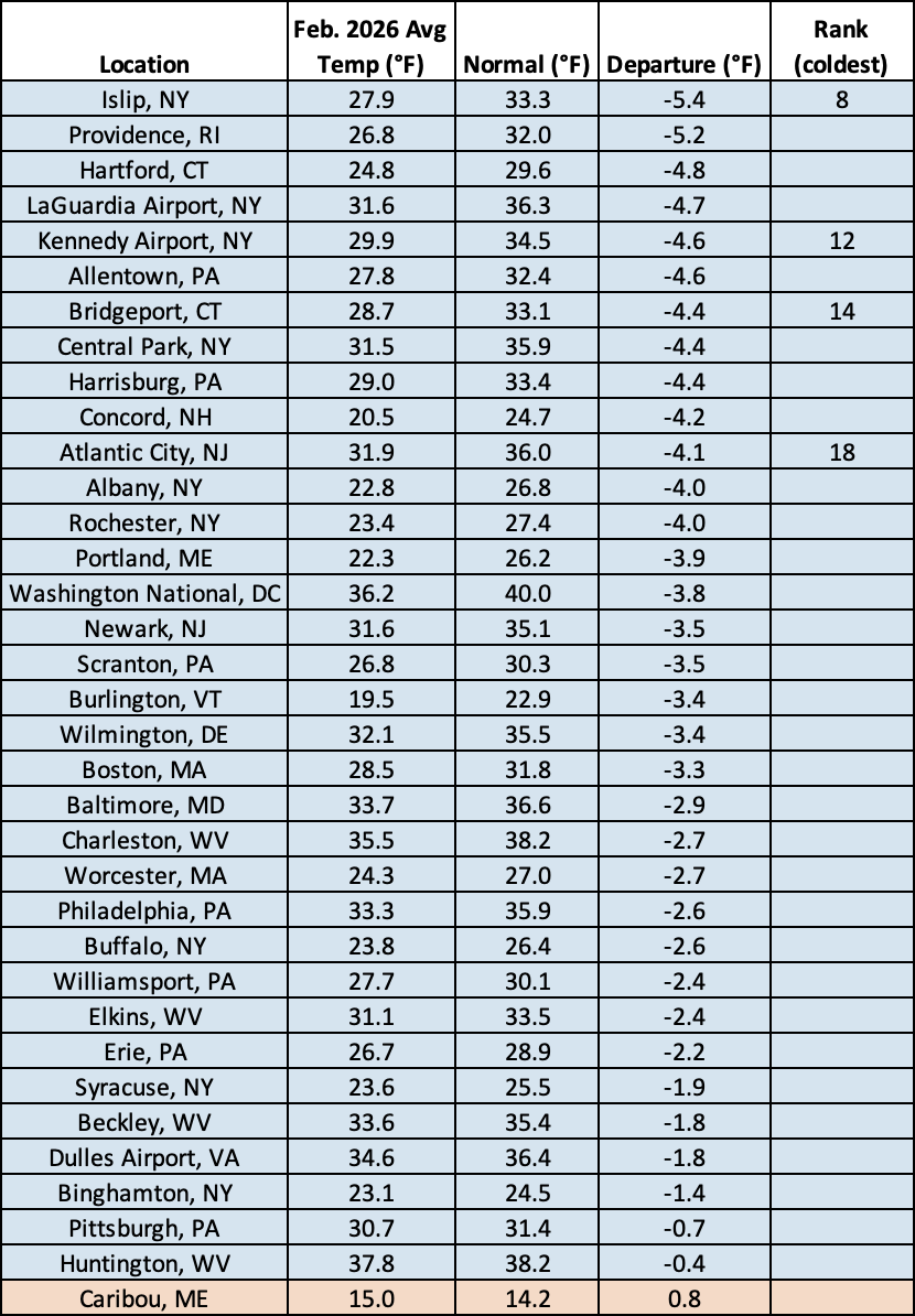
This February was among the 20 coldest Februarys on record for four major sites.
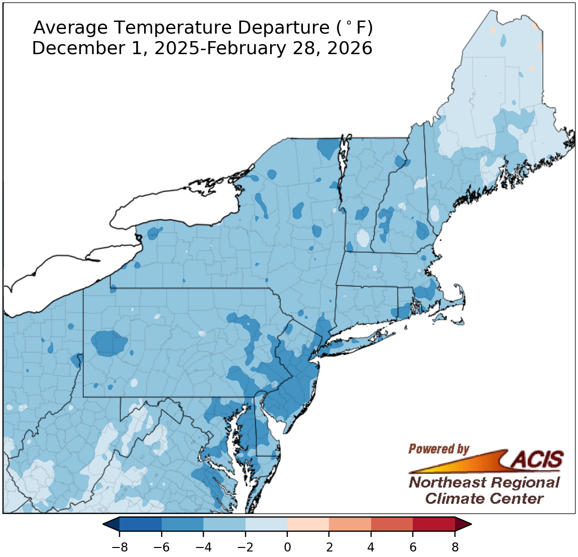
Winter average temperatures ranged from 6°F below normal to near normal.
December, January, and February were colder than normal for most of the Northeast, so average temperatures for the winter season ranged from 6°F below normal to near normal. The largest departures below normal tended to be in areas closer to the coast. Winter average temperatures at the major climate sites ranged from 5.4°F below normal in Allentown, PA, to 1.3°F below normal in Huntington, WV, with several sites having their coldest winter since the 2014-15 winter season. This winter ranked among the 20 coldest winters on record for seven major sites.
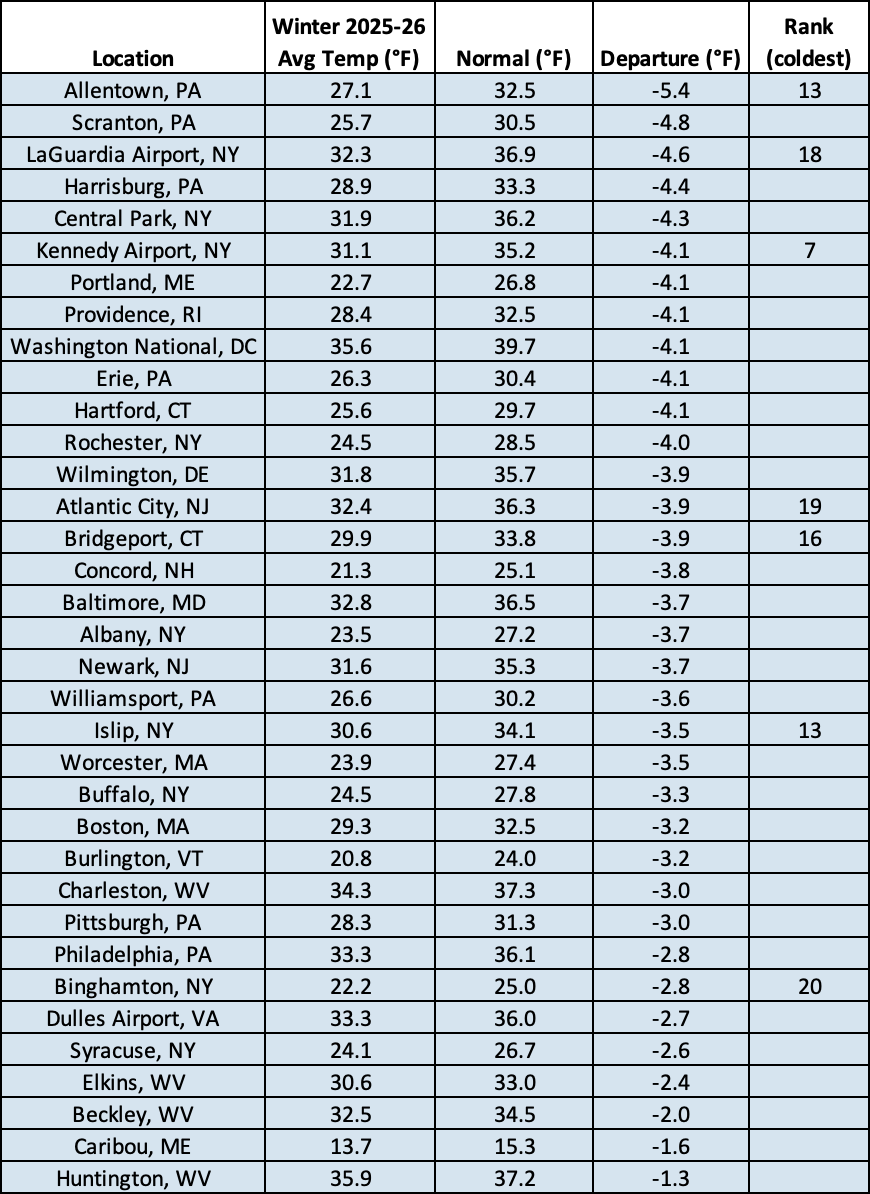
Winter 2025-26 ranked among the 20 coldest winters on record for seven major sites.
According to NOAA’s Climate Prediction Center, March is expected to be wetter than normal for interior portions of the Northeast. Equal chances of below-, near-, or above-normal precipitation is forecast for areas closer to the coast. Meanwhile, the entire Northeast is expected to average out to be warmer than normal for March, with the highest likelihood in parts of West Virginia.
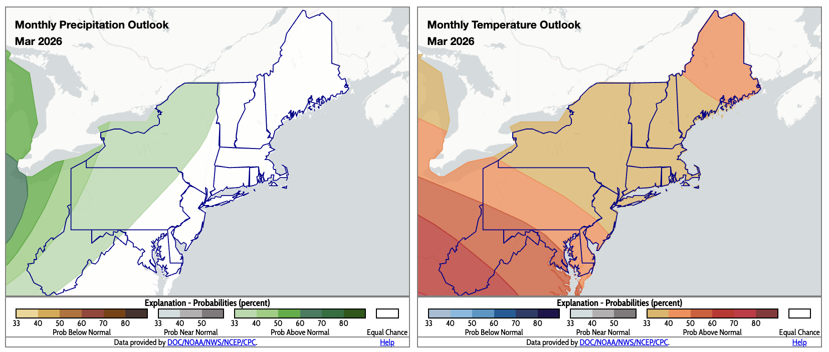
For March, there’s an increased likelihood of above-normal precipitation for interior locations (shaded green) and above-normal temperatures for the entire region. Click to enlarge.