Wet Weather Wednesday
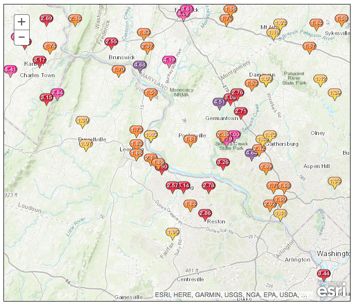
24-hour rainfall totals for July 8 in areas northwest of Washington, D.C. Image courtesy of NWS Baltimore-Washington. Click to enlarge.
Extreme rainfall led to significant flash flooding in portions of Maryland, Virginia, and West Virginia on July 8. Washington National, D.C., received 3.30 inches of rain, nearly a July’s worth, in an hour. This event exceeded the 100-year return period, meaning rainfall of that magnitude has a 1% chance of occurring in a given year. The greatest 24-hour rain totals across the three-state area approached 5 inches. A rare Flash Flood Emergency was issued by the National Weather Service as waterways rose quickly in response to the deluge. For instance, preliminary data shows Seneca Creek at Dawsonville, MD, rose more than 5 feet in an hour.
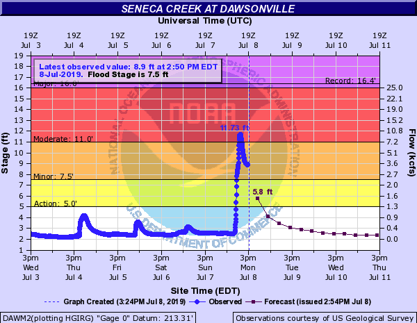
The water level (blue line) rose rapidly in response to heavy rain. Image courtesy of NOAA.
The event earlier this week falls in line with the wetter-than-normal pattern much of the Northeast (and the nation) has been experiencing over the past several months. If you compared every July through June period since 1895, the most recent period of July 2018-June 2019 ranked as the wettest for the Northeast. During that time, the region received 57.43 inches of precipitation, 15.39 inches above average (based on 1901-2000). Now if you looked at every 12-month period, July 2018-June 2019 would rank as third wettest, with the record wettest being October 2010-September 2011 with 58.40 inches, 16.34 inches above average.
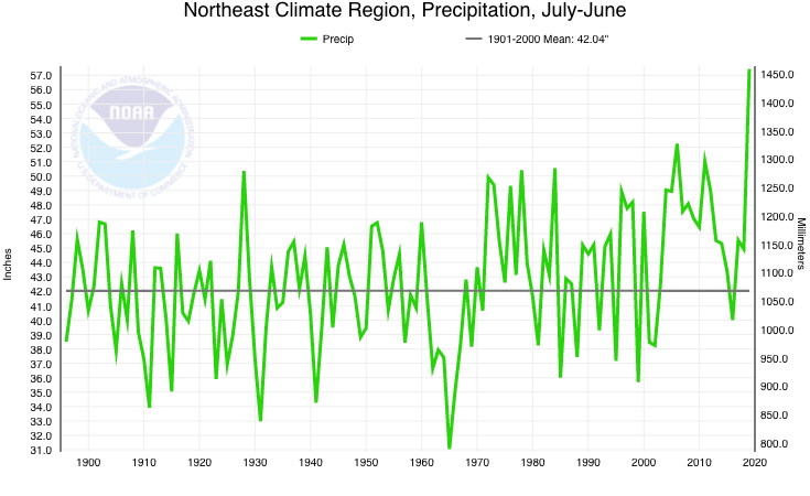
The Northeast had its wettest July through June period on record. Image courtesy NCEI. Click to enlarge.
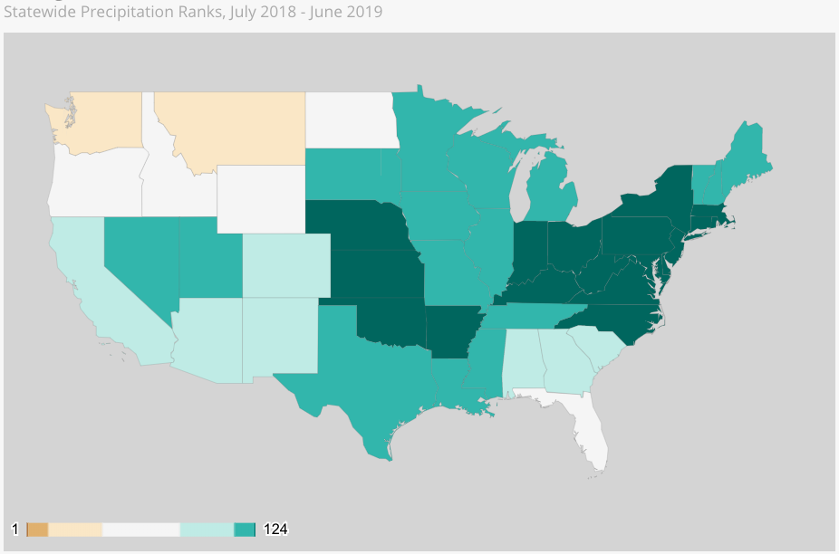
States shaded dark green had their wettest July through June period on record. Image courtesy NCEI. Click to enlarge.
Of the 12 Northeast states, nine of them (all except northern New England) also had their wettest July through June period on record. And at the city level, four major climate sites wrapped up their wettest 12-month period on record - Wilmington, DE, and Allentown, Scranton, and Williamsport, PA. In fact, for two of those sites, Allentown and Scranton, the August 2018-July 2019 period already ranks among the five wettest 12-month periods on record with three weeks left to go in July! In addition, the region, several states, and some cities were record wet at several other time scales.
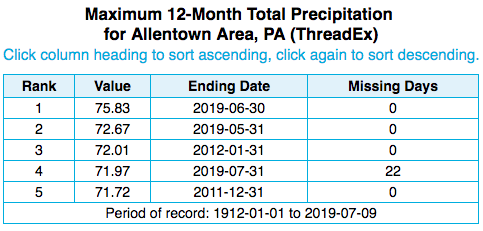
The five wettest 12-month periods on record at Allentown, PA. The site had a surplus of over 30 inches for the July 2018-June 2019 period.
Short-term outlooks from NOAA’s Climate Prediction Center show much of West Virginia, the western third of Pennsylvania, and a small portion of western Maryland and western New York have an increased likelihood of above-normal rainfall over the next two weeks. On the other end of the spectrum, parts of New England, eastern New York, and New Jersey could be drier than normal. Near-normal precipitation was predicted for the rest of the Northeast.
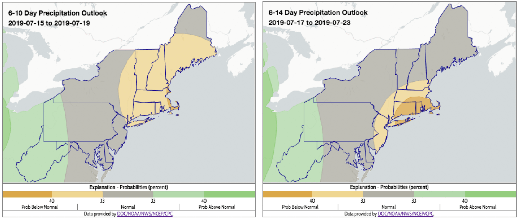
Over the next two weeks, areas shaded green have an increased chance of wetter-than-normal conditions. Click to enlarge.