Hurricane Season on the Horizon
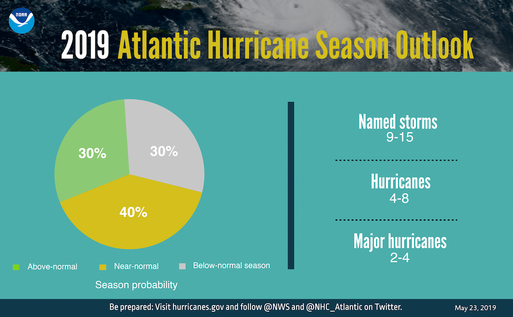
The 2019 Atlantic hurricane season is expected to be near normal.
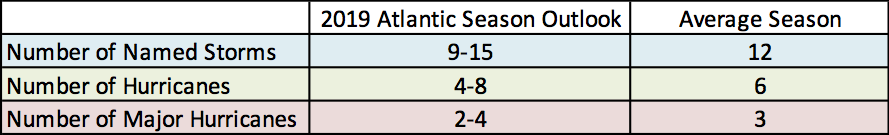
The 2019 Atlantic hurricane season forecast compared to an average season.
While the official start of hurricane season is June 1, for the fifth consecutive year, Mother Nature jumped the gun. This year, it was with the short-lived Subtropical Storm Andrea. NOAA’s 2019 Atlantic hurricane outlook, which includes Andrea, says a near-normal Atlantic hurricane season is most likely, with “a likely range of 9 to 15 named storms (winds of 39 mph or higher), of which 4 to 8 could become hurricanes (winds of 74 mph or higher), including 2 to 4 major hurricanes (Category 3, 4 or 5; winds of 111 mph or higher).” Hurricane season peaks from mid-August to late October when ocean temperatures are the warmest and atmospheric conditions are the most conducive to storm development. The season wraps up on November 30.
The hurricane outlook does not predict the number of storms that will make landfall or the impacts the storms may have. For instance, only four of the 15 named storms last year made landfall in the U.S. but two of them, Florence and Michael, were devastating. Florence brought record flooding to the Carolinas and Michael was the strongest hurricane on record to hit the Florida Panhandle. The southeastern and southern parts of the country tend to be struck by tropical systems more frequently than the Northeast. However, almost every coastal county in the Northeast has been struck by a hurricane at least once.
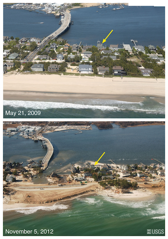
Images of Mantoloking, NJ, before and after Sandy.
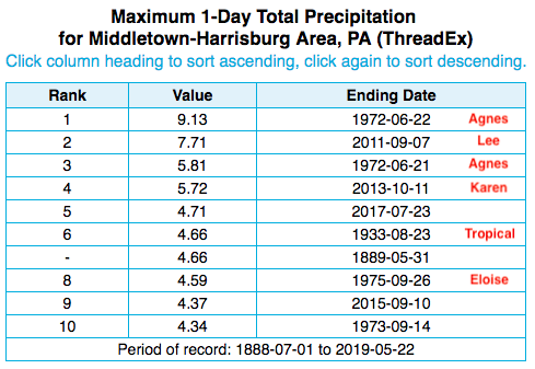
Four of the five wettest days at Harrisburg, PA, were associated with tropical systems.
Direct strikes, tropical systems passing close by, and the remnants of tropical systems can all have major impacts. Storm surge can cause severe flooding and damage in coastal areas and along bays and waterways several miles inland. Sandy’s surge arrived near high tide, setting record-high water levels. Rip currents are another coastal hazard.
Tropical systems can produce extreme rainfall and flooding, even inland. Four of the five wettest days since 1888 at Harrisburg, PA, were associated with tropical systems - Agnes in 1972 (two days), Lee in 2011, and Karen in 2013. In 2011, the combination of saturated ground and rainfall from Hurricane Irene and Tropical Storm Lee caused historic flooding, particularly in parts of Vermont, New York and Pennsylvania.
Hurricanes also produce damaging winds and tornadoes. For instance, 26 tornadoes touched down in the Baltimore/Washington National Weather Service coverage area in association with the remnants of Ivan in mid-September 2004. Eight of those tornadoes were in Maryland, with the event still ranking among one of the largest tornado outbreaks in the state since records began in 1950.
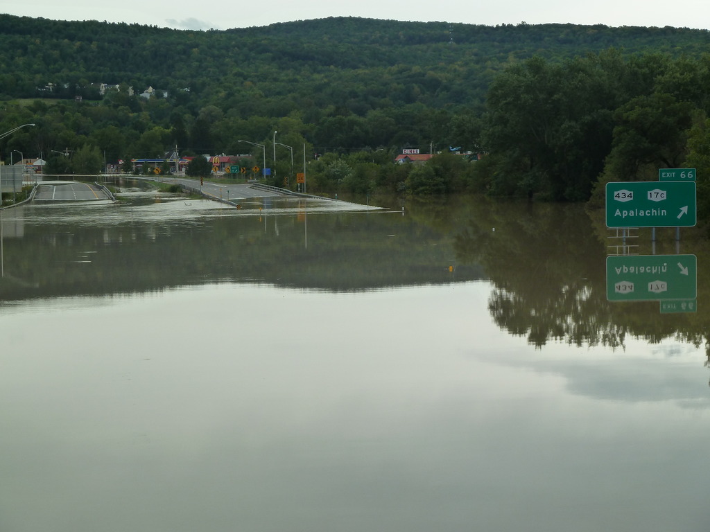
Flooding in New York after Tropical Storm Lee in September 2011. Image courtesy NWS Binghamton.
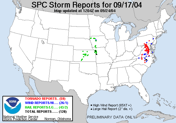
The red triangles are tornado reports associated with Ivan.
It’s important to prepare before a storm arrives. For safety information and resources, go to the National Weather Service’s hurricane page - http://www.nws.noaa.gov/om/hurricane. To see if there are any active tropical systems and for a 5-day outlook, visit the National Hurricane Center’s website at https://www.nhc.noaa.gov/. If there is an approaching storm, your local National Weather Service office is a great resource for additional updates and information - https://www.weather.gov/.
An updated outlook will be issued by NOAA in August.