Fallen Records
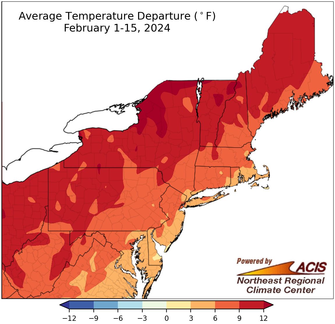
February 1-15 average temperatures ranged from near normal to more than 12°F above normal.
The first half of February was exceptionally warm across the Northeast, with average temperatures ranging from near normal in the region’s southeastern corner to more than 12°F above normal in northern New York and parts of northern New England. This February 1-15 period was record warm at nine of the Northeast’s 35 major climate sites and ranked among the 10 warmest at another 25 of the sites. Overall, average temperatures during the first half of February at the major climate sites ranged from 3.6°F above normal in Atlantic City, NJ, its 13th warmest, to 11.9°F above normal in Syracuse, NY, its record warmest.
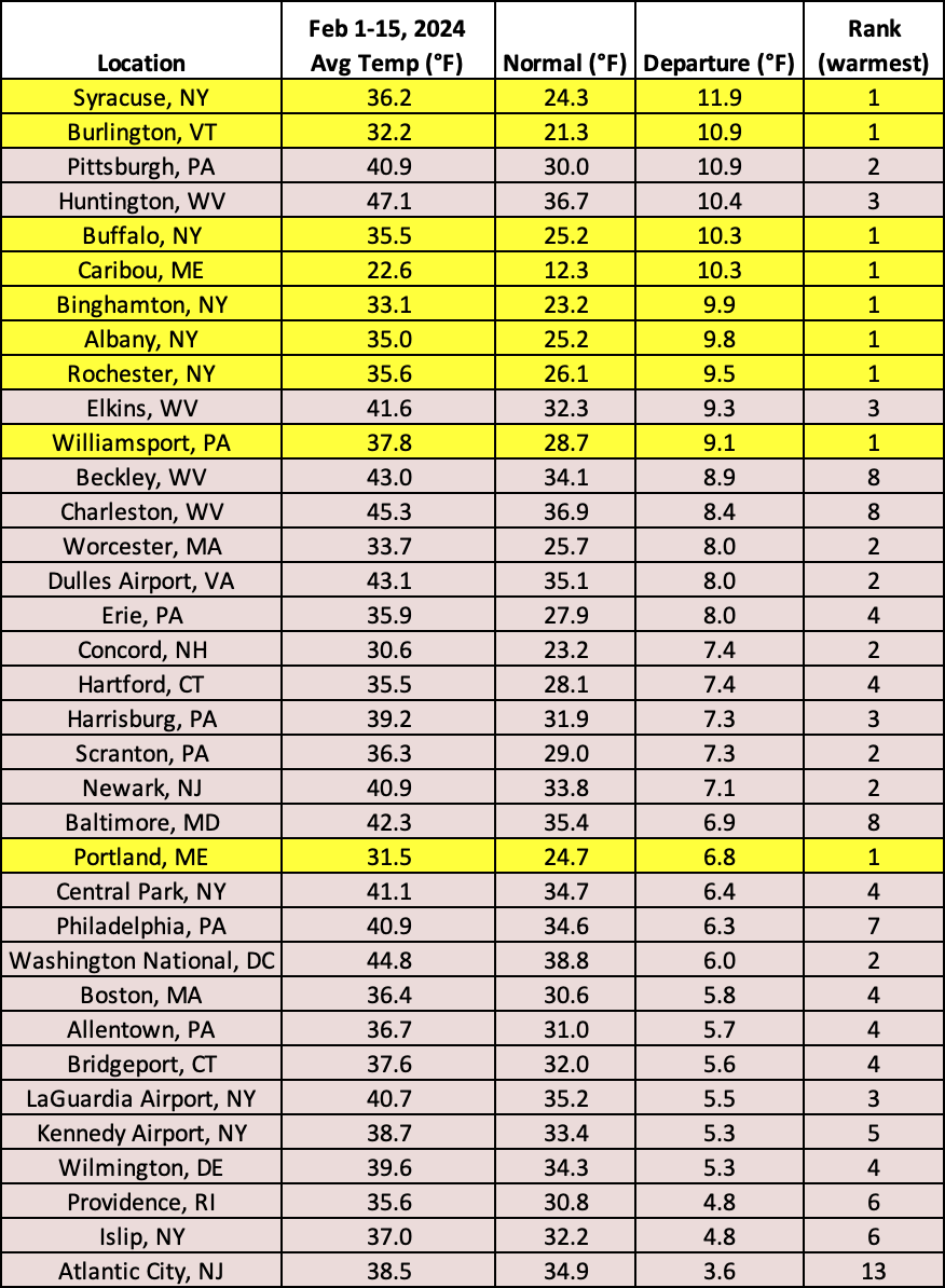
This February 1-15 period was record warm for nine major climate sites and among the 10 warmest for another 25 of the sites.

February 1-15 precipitation ranged from less than 25% of normal to 200% of normal.
Most of the Northeast experienced drier-than-normal conditions during the first half of February. An area extending from northern West Virginia through Pennsylvania and New York and into New England saw less than 25% of normal precipitation. Only a few areas in the Mid-Atlantic, particularly West Virginia, were wetter than normal, seeing up to 200% of normal precipitation. At the 35 major climate sites, February 1-15 precipitation ranged from 1% of normal in Portland, ME, to 155% of normal in Charleston, WV, with only three climate sites being wetter than normal. This first half of February was record dry for Pittsburgh, PA, and among the 20 driest for another 18 major climate sites.
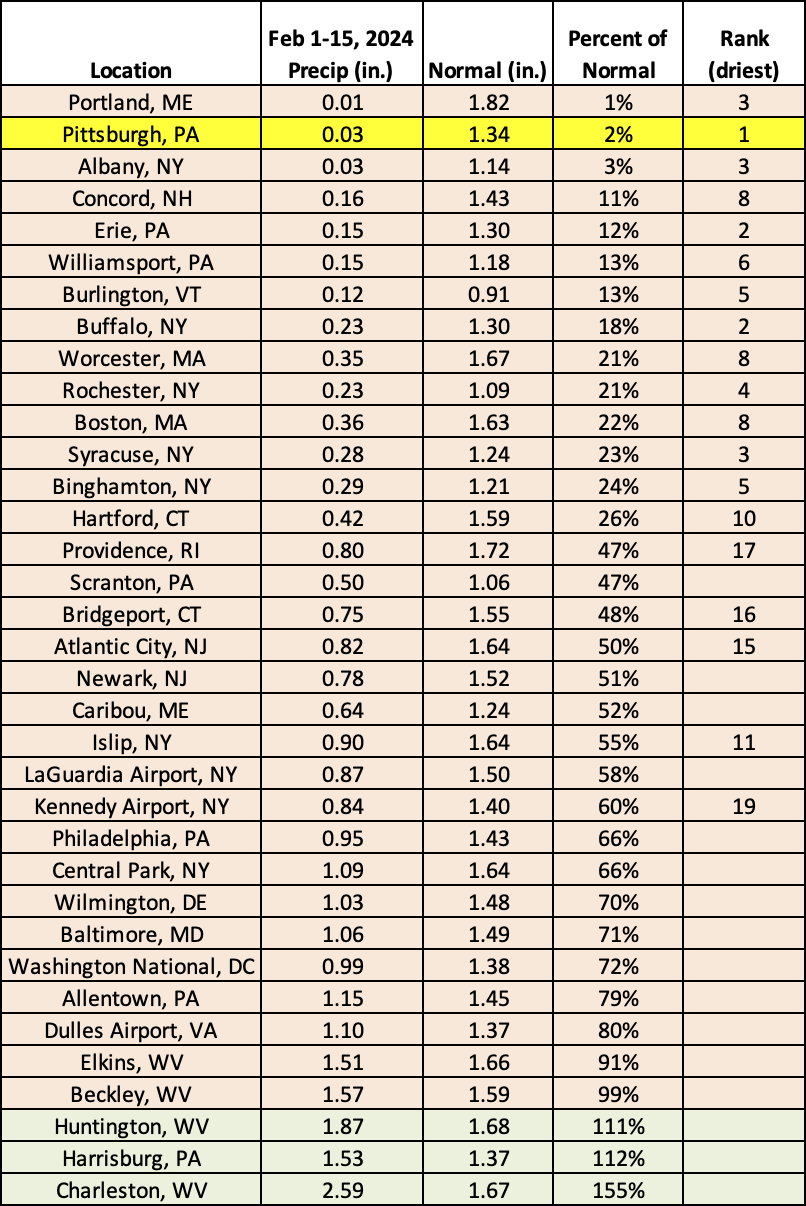
This February 1-15 period was record dry for Pittsburgh, PA, and among the 20 driest for another 18 major climate sites.
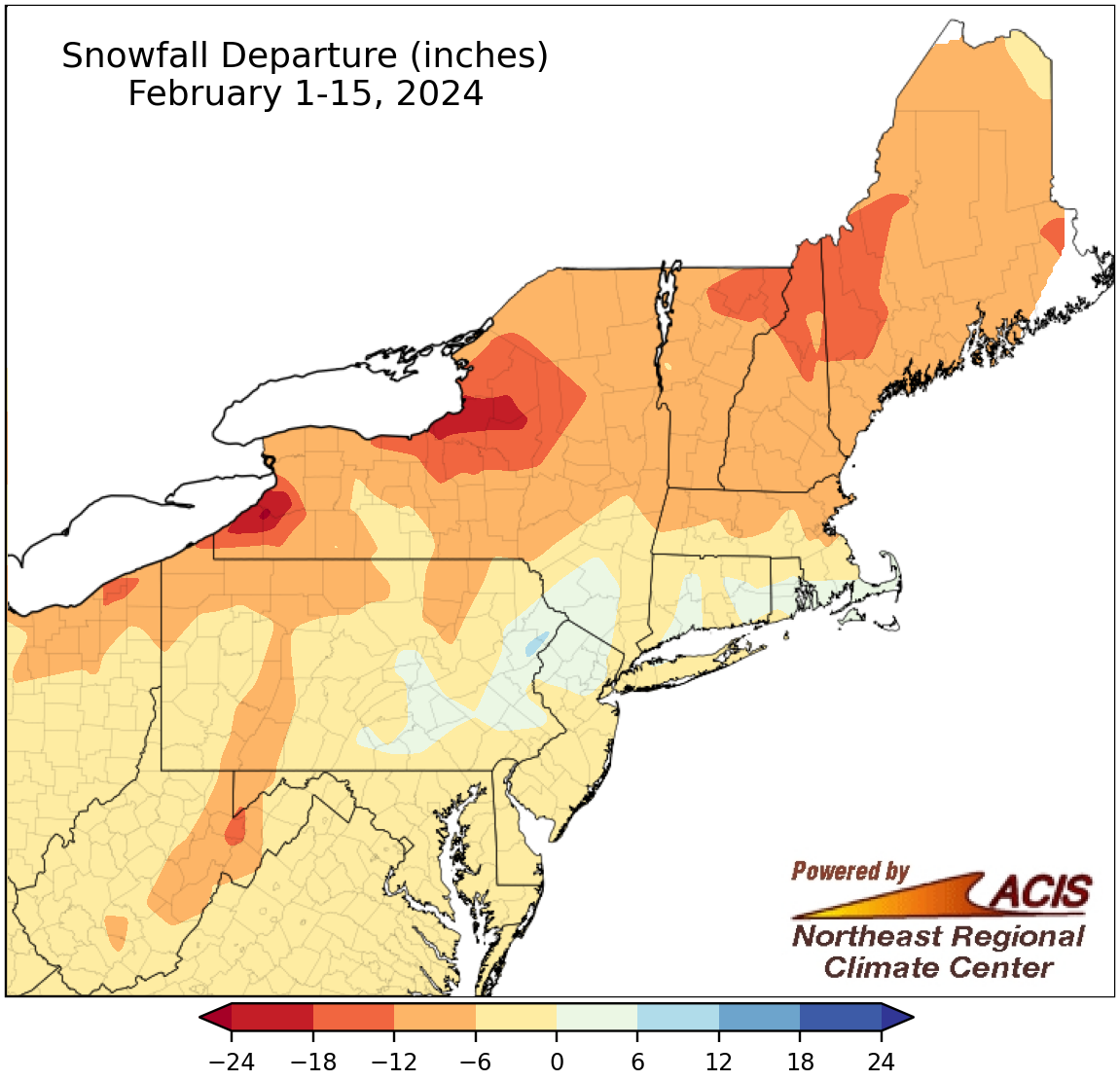
February 1-15 snowfall ranged from 24 inches below normal to 6 inches above normal.
With above-normal temperatures and limited storms, snowfall totals during the first half of February were also below normal for most of the Northeast. The largest deficits of up to 24 inches were found east of the Great Lakes in New York. Thirty-one of the region’s 35 major climate sites saw below-normal snowfall from February 1-15, with the period featuring record-low snowfall, only a trace, for Erie and Pittsburgh, PA, and ranking among the 20 least snowy for another 15 major climate sites.
Conversely, a handful of locations from central Pennsylvania into southern New England saw more snow than typically snowy spots such as upstate New York and northern New England, wrapping up the period with a snowfall surplus of up to 6 inches from a storm just before Valentine’s Day. Four major climate sites were snowier than normal, with Allentown having its 19th snowiest first half of February. Overall, at the 35 major climates sites, February 1-15 snowfall ranged from 14.0 inches below normal in Syracuse, NY, to 2.9 inches above normal in Allentown, PA.
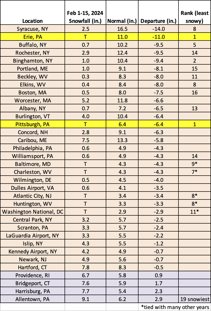
This February 1-15 period featured record low snowfall at Erie and Pittsburgh, PA, and ranked among the 20 least snowy for another 15 major climate sites. Conversely, it was the 19th snowiest at Allentown, PA.
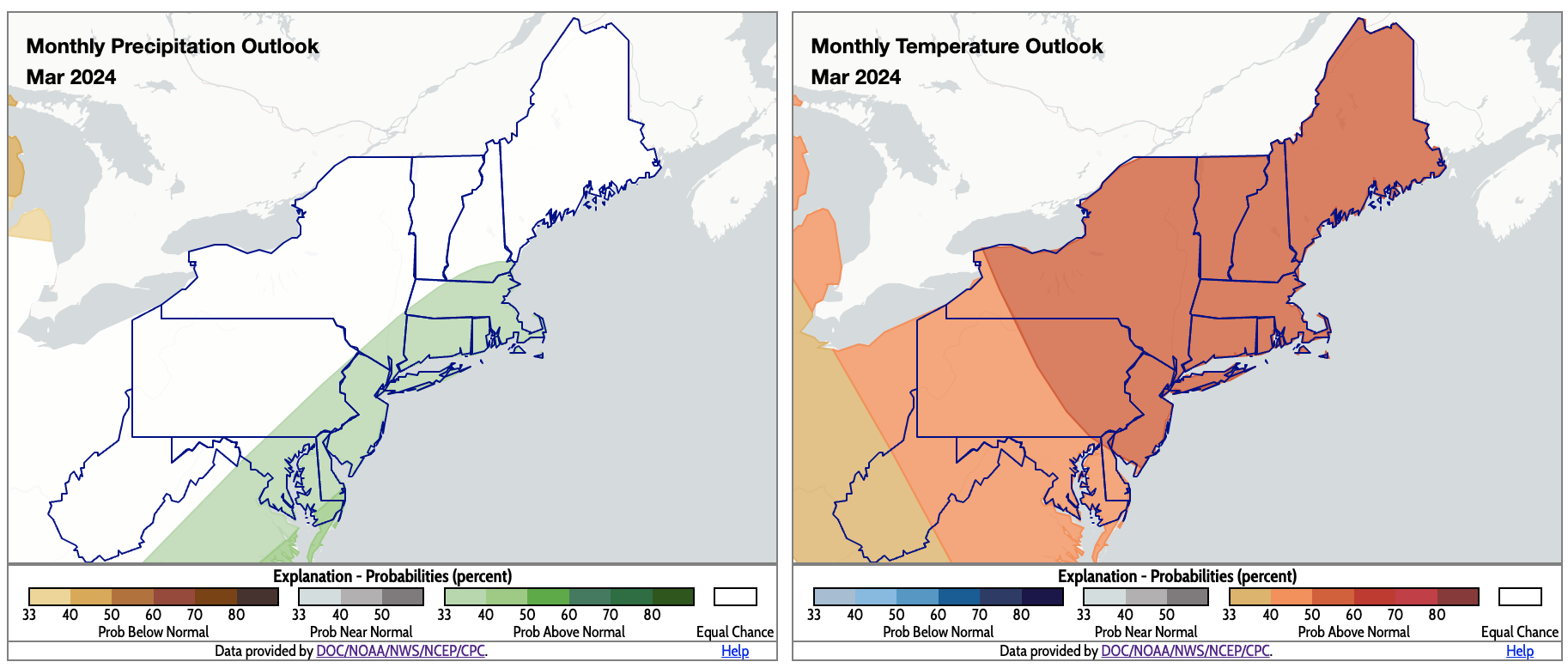
For March, coastal areas could be wetter than normal, while the whole region is expected to be warmer than normal. Click to enlarge.
The March precipitation outlook from NOAA’s Climate Prediction Center resembles what would be expected during an El Niño winter in the Northeast - a tilt toward wetter-than-normal conditions for coastal areas. Equal chances of below-, near-, or above-normal precipitation were forecast for the rest of the region. Meanwhile, there’s an increased likelihood for above-normal temperatures for the whole Northeast for March.