A Record-Setting January
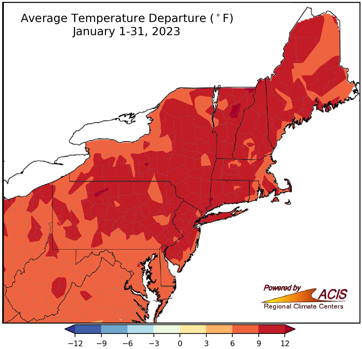
January average temperatures ranged from 6°F to 12°F above normal.
The Northeast experienced an exceptionally warm January, with average temperatures running 6°F to 12°F above normal. In fact, this January was the warmest since record-keeping began for 10 of the 35 major climate sites including Dulles Airport, VA; Allentown, PA; Central Park, NY; Worcester, MA; and Portland, ME. At the remaining sites, this January ranked among the five warmest for 16 sites, the 10 warmest for five sites, and the 20 warmest for four sites. January average temperatures at the major climate sites ranged from 6.2°F above normal in Erie, PA, to 11.2°F above normal in Newark, NJ. The average temperature was above normal every day during January for sites such as Philadelphia, PA, and Central Park, which were experiencing their longest such streak at 35 days as of January 31. At most sites, both high and low temperatures were unusually warm.
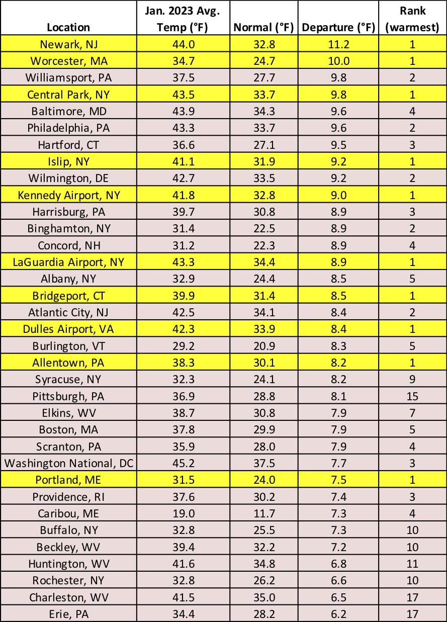
January 2023 was record warm for 10 major climate sites and ranked among the 20 warmest for the other 25 climate sites.
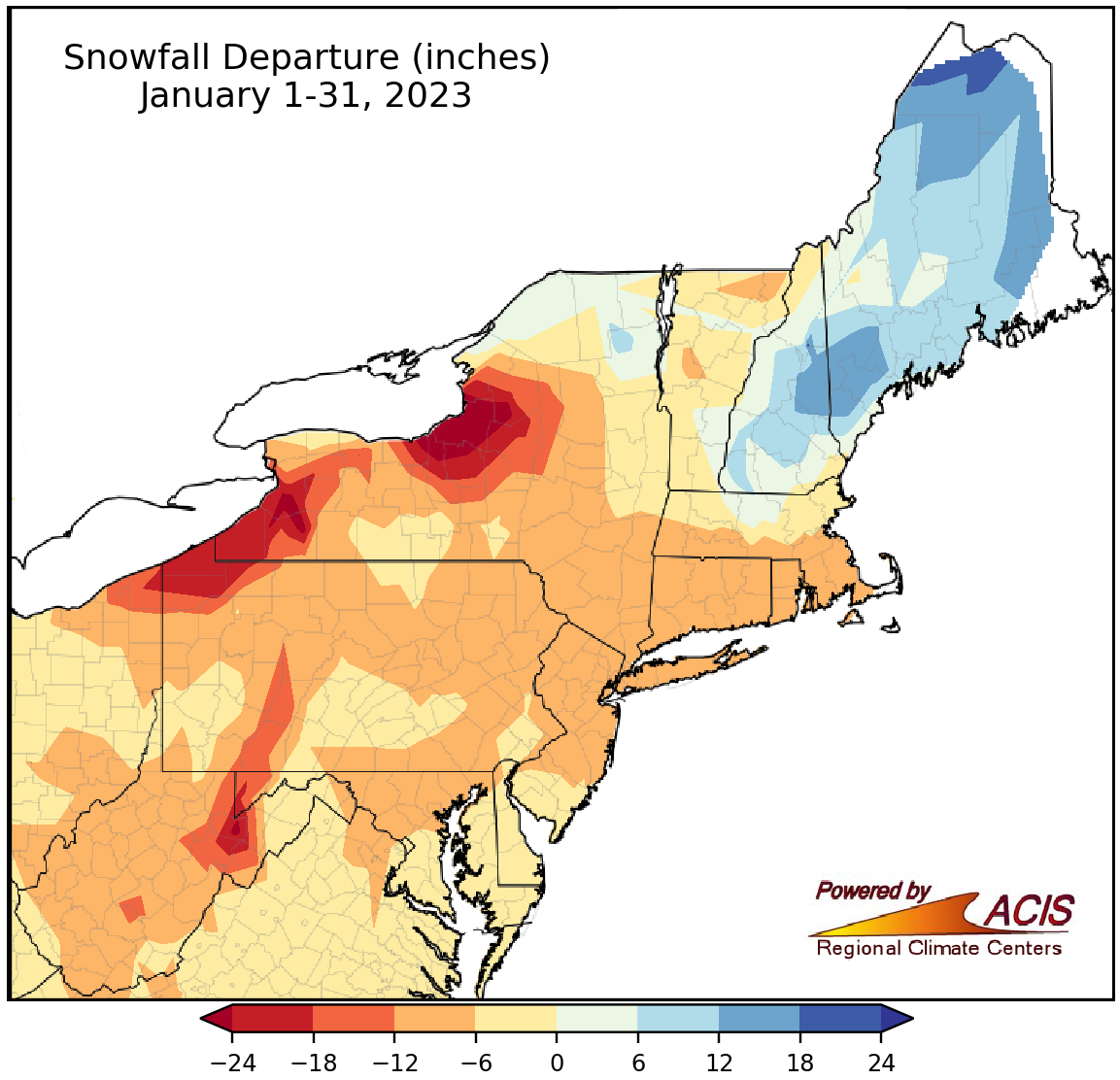
January snowfall ranged from more than 24 inches below normal to 18 inches above normal.
Most of the Northeast saw below-normal snowfall during January, with a large swath of the region seeing deficits of 6 to 12 inches and the largest deficits of more than 24 inches in lake-effect areas of New York. This January ranked as the least snowy on record for 10 major climate sites including Washington, D.C.; Philadelphia, PA; Newark, NJ; Kennedy Airport, NY; and Bridgeport, CT. None of these sites saw measurable snowfall during January. For Bridgeport it was the first January on record without measurable snow. In fact, several sites, including Washington, D.C.; Philadelphia; and Central Park, have not seen measurable snow at all this snow season. For sites such as Central Park, which has records back to 1869, it will be the latest first measurable snowfall on record, currently running more than a month-and-a-half later than usual.
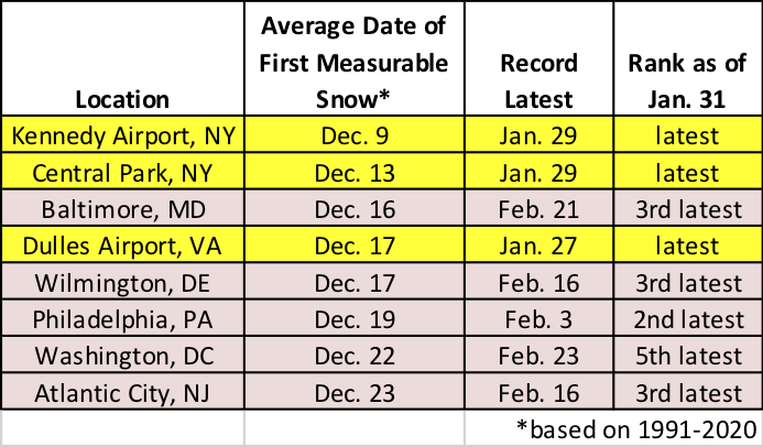
Several sites have yet to see measurable snow this season, with measurable snow at the sites highlighted yellow being record late.
This January ranked among the 20 least snowy on record for another 13 major climates sites. However, parts of Maine and New Hampshire, which saw back-to-back snowstorms in late January, were the snowy exceptions. This January ranked among the 20 snowiest on record for Caribou, ME, and Concord, NH. Overall at the 35 major climate sites, January snowfall ranged from 23.8 inches below normal in Syracuse, NY, to 13.0 inches above normal in Caribou, ME, with 32 sites having snowfall deficits.
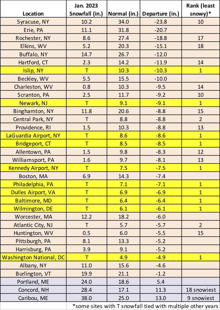
This January was the least snowy on record for 10 major climate sites and ranked among the 20 least snowy for another 13 of the sites. However, two sites saw one of their 20 snowiest Januaries.
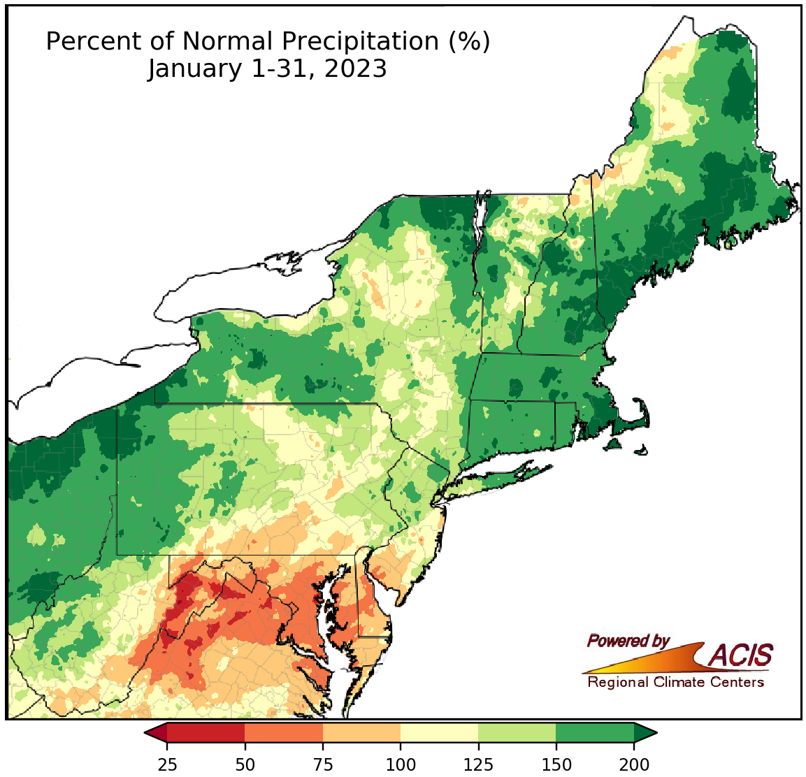
January precipitation ranged from 25% of normal to more than 200% of normal.
Much of the precipitation that fell during January was rain or a mix of precipitation types. Southern parts of the Northeast including Delaware, Maryland, and eastern West Virginia were drier than normal, with some spots seeing less than 50% of normal precipitation. However, a majority of the Northeast experienced a wetter-than-normal January, with several areas such as coastal Maine, southeastern Massachusetts, northern New York, and northwestern Pennsylvania seeing more than 200% of normal precipitation. At the 35 major climate sites, January precipitation ranged from 46% of normal at Dulles Airport, VA, to 221% of normal in Portland, ME, with 28 of the sites wrapping up January on the wet side of normal. This January ranked among the 20 driest for three major climate sites but among the 20 wettest for 13 of the sites.
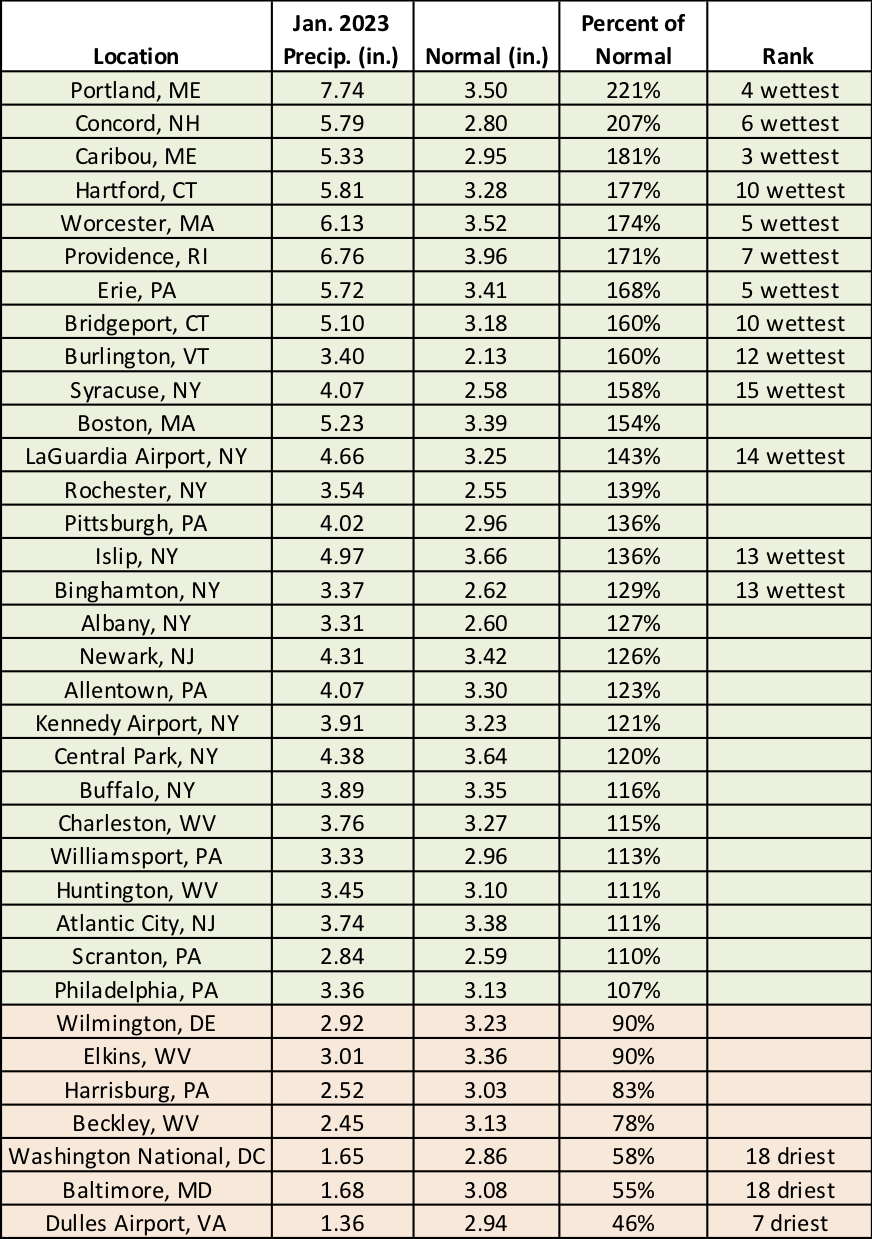
This January ranked among the 20 driest for three major climate sites but among the 20 wettest for 13 of the sites.
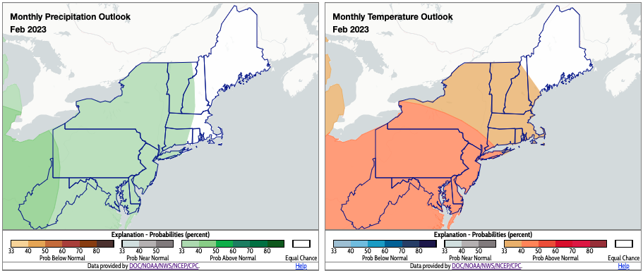
For February, NOAA’s Climate Prediction Center favors above-normal precipitation and above-normal temperatures for much of the Northeast. Click to enlarge.
The February precipitation outlook map from NOAA’s Climate Prediction Center indicates there’s a tilt toward above-normal precipitation for much of the Northeast, with the greatest chance in portions of West Virginia and southwestern Pennsylvania. The temperature outlook for February shows an increased likelihood of above-normal temperatures for most of the region, particularly for portions of New York and areas to the south.