Springing into Summer
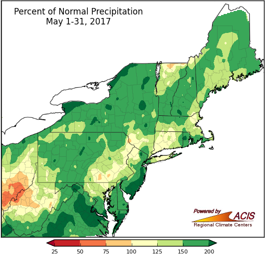
May was wetter than normal for almost the entire Northeast.
It was a soggy May, with much of the Northeast seeing from 100% to 200% of normal precipitation. The wettest areas, with more than 200% of normal, were in portions of New York, coastal New Jersey, and southeastern Maryland. In fact, Buffalo and Rochester, NY, received an entire May’s worth of rain in just the first week of the month! However, a portion of central/western West Virginia did see drier-than-normal conditions. All but two of the region’s 35 major climate sites received above-normal precipitation, with 24 ranking this May among their top 20 wettest on record. The above-normal precipitation helped end drought conditions across the Northeast, with the region becoming drought-free (in early May 2017) for the first time since April 2016.
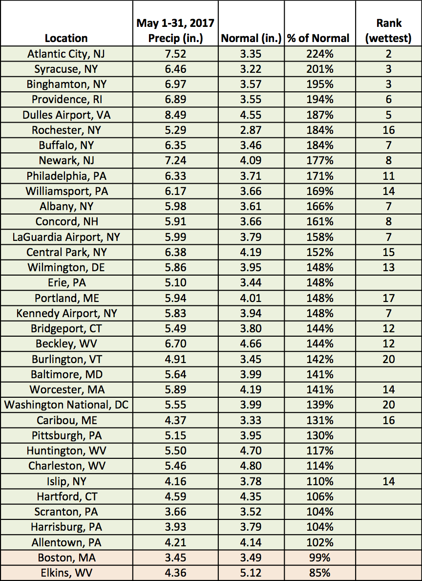
May precipitation at the major climate sites ranged from 85% of normal in Elkins, WV, to 224% of normal in Atlantic City, NJ.
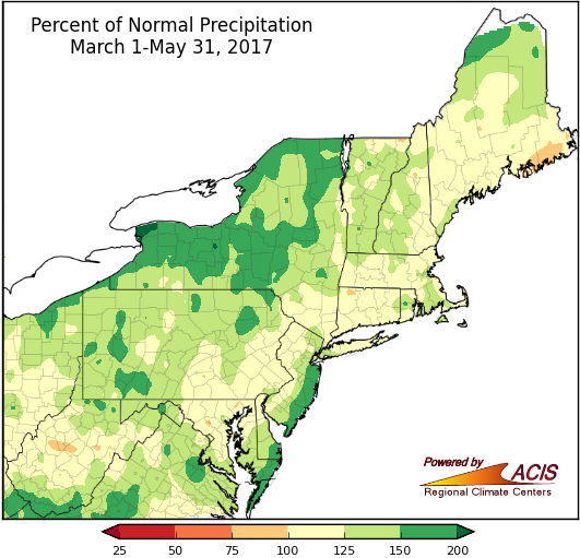
Spring ended up on the wet side of normal for the Northeast.
March precipitation varied but April and May were both generally wetter than normal, so spring also ended up wetter than normal. Spring precipitation ranged from near normal to 200% of normal, with some of the wettest areas in parts of New York and coastal New Jersey. Thirty-four major climate sites received above-normal precipitation, with 25 of them ranking this spring among their top 20 wettest on record.
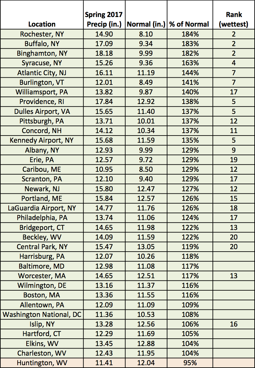
Spring precipitation at the major climate sites ranged from 95% of normal in Huntington, WV, to 184% of normal in Rochester, NY.
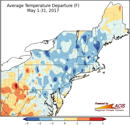
A large portion of the Northeast saw near- to below-normal May average temperatures.
For most of the Northeast, May started off chilly, warmed up mid-month, then wrapped up on the cool side. From May 17-19, several sites had one of their top five warmest spring days on record as high temperatures reached 90°F or above. In fact, LaGuardia Airport, NY, and Burlington, VT, tied their warmest spring temperatures on record with highs of 97°F and 93°F, respectively. Overall, May average temperatures ranged from 3°F below normal to 2°F above normal, with temperatures in most areas near to below normal. The coolest spots were generally in portions of New York and New England, while the warmest spots were generally in West Virginia. Of the region’s 35 major climate sites, 21 were cooler than normal in May, with Worcester, MA, having its 20th coldest.
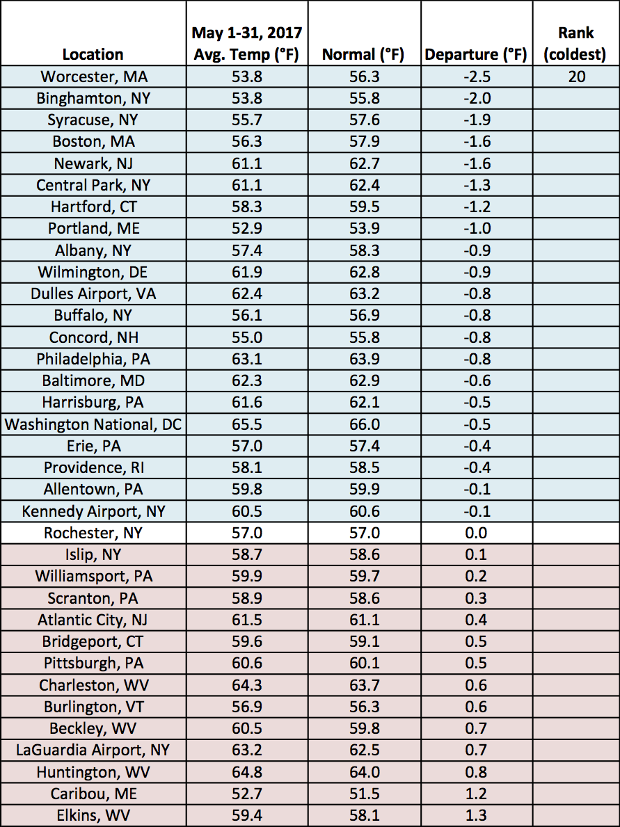
May average temperatures at the major climate sites ranged from 2.5°F below normal in Worcester, MA, to 1.3°F above normal in Elkins, WV.
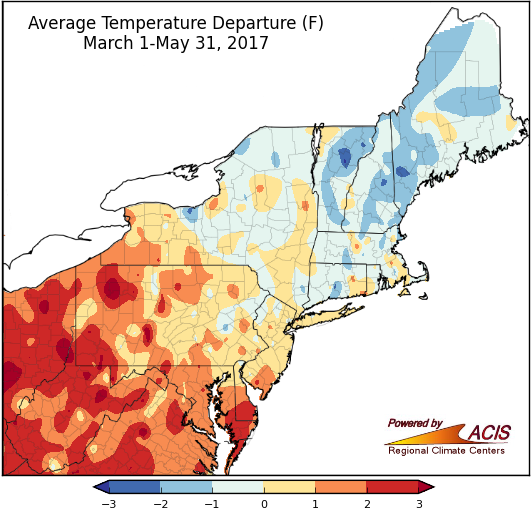
During spring, northeastern parts of the region tended to be the coolest, while southwestern portions of the region tended to be the warmest.
March temperatures were generally near to below normal, while April featured record to near-record warmth and May temperatures were also generally near to below normal. Overall, spring average temperatures ranged from 2°F below normal in northern New England to 3°F above normal in West Virginia and western Pennsylvania. Twenty-five of the major climate sites experienced a warmer-than-normal spring, with 12 of them ranking this spring among their top 20 warmest on record.
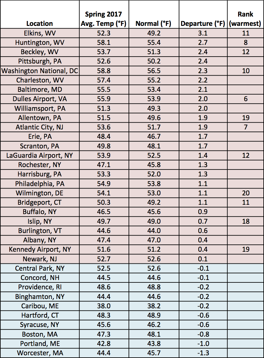
At the major climate sites, spring average temperatures ranged from 1.3°F below normal in Worcester, MA, to 3.1°F above normal in Elkins, WV.
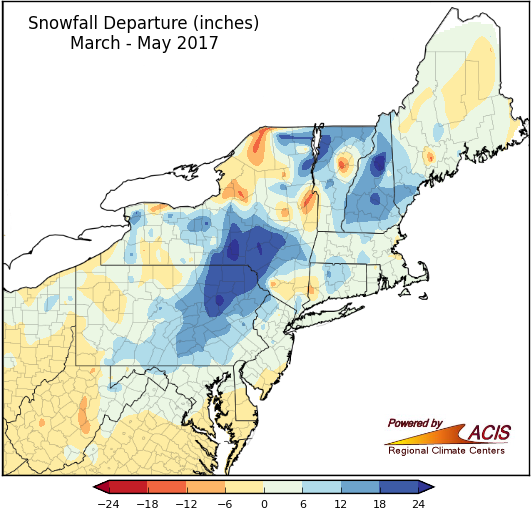
Spring snowfall was near to above normal in many areas.
March was snowier than normal for much of the region, mainly due to a mid-month Nor’easter. April snowfall was generally near to below normal, except in portions of northern New England. In May, no sites received measurable snowfall. With that, spring snowfall ranged from 12 inches below normal in parts of northern New York and central West Virginia to more than 24 inches above normal in central New York. Twenty-nine of the 35 major climate sites were snowier than normal, with 19 of them ranking this spring among their top 20 snowiest. Conversely, two ranked this spring among their top 20 least snowy.
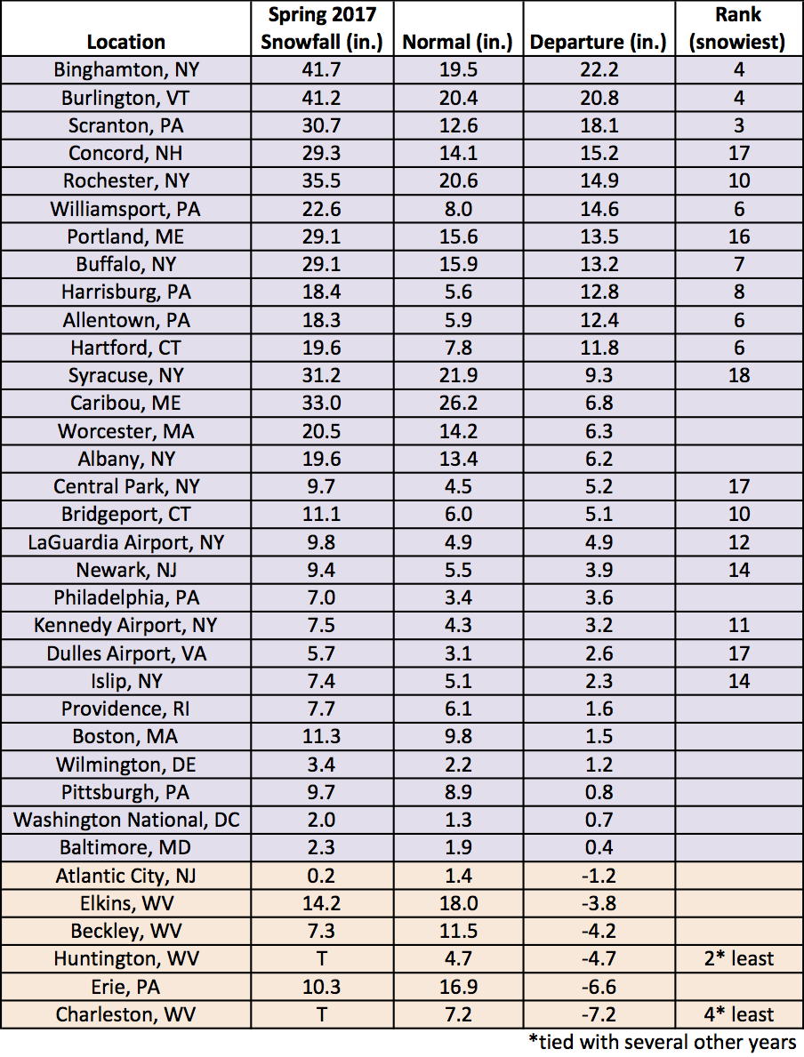
Spring snowfall at the airport climate sites ranged from 7.2 inches below normal in Charleston, WV, to 22.2 inches above normal in Binghamton, NY.
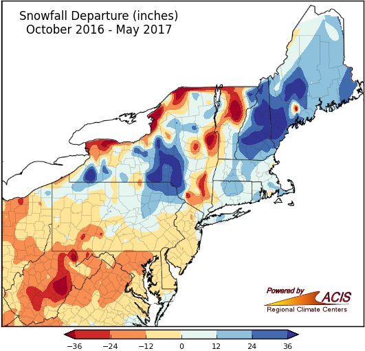
Seasonal snowfall varied, but was generally near to below normal in the Mid-Atlantic and near to above normal in New England.
The snow season, which runs from October through May, was variable, ranging from more than 36 inches below normal to more than 36 inches above normal. The least snowy spots were found in portions northern Vermont, eastern West Virginia, and near Lake Ontario in New York, while the snowiest spots were in central New York, southern Maine, and New Hampshire. Twenty of the major climate sites were snowier than normal, with 10 of them ranking this snow season among their top 20 snowiest. In fact, for Binghamton, NY, is was the snowiest season on record. Just last year the site had its least snowy season on record. On the other hand, seven sites ranked this season among their top 20 least snowy on record.
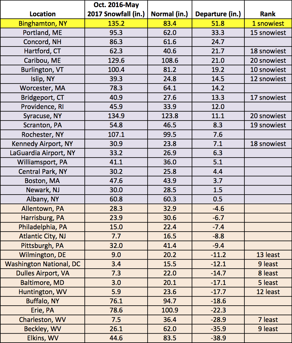
At the major climate sites, seasonal snowfall ranged from 38.9 inches below normal in Elkins, WV, to 51.8 inches above normal in Binghamton, NY, which was their snowiest season on record.
How is summer shaping up? Well, NOAA’s Climate Prediction Center (CPC) indicates there’s an increased chance of above-normal temperatures for the Northeast during summer, but the precipitation outlook calls for equal chances of below-, near-, or above-normal precipitation.
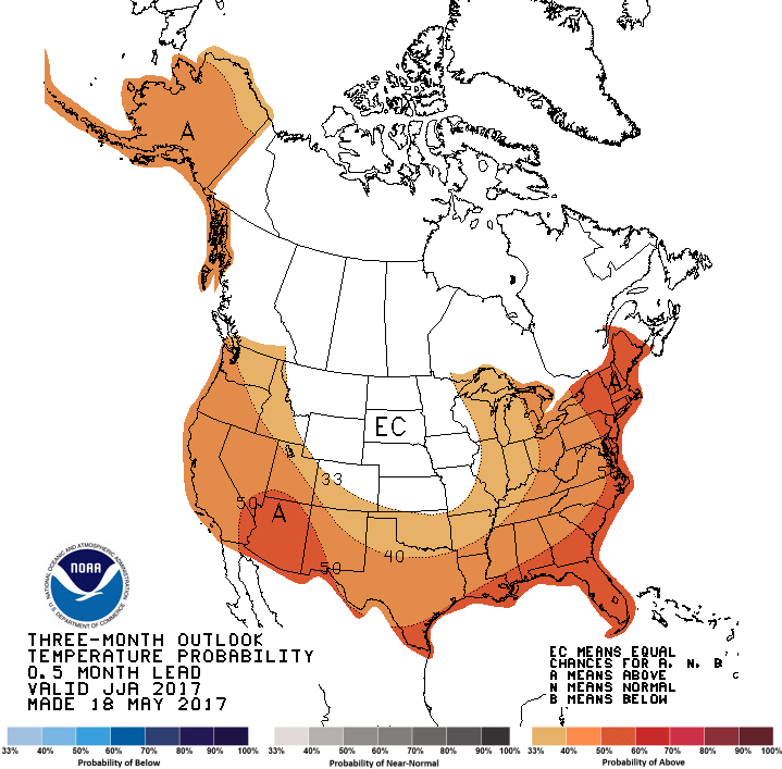
CPC’s summer temperature outlook indicates increased chances of above-normal temperatures.
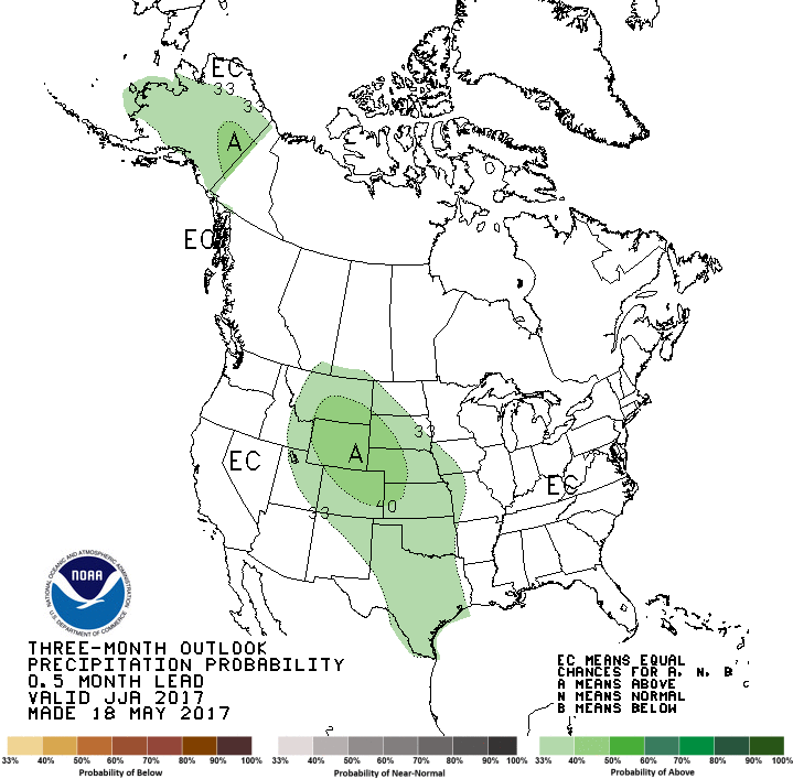
The precipitation outlook for summer from CPC indicates equal chances.