A Wintry Second Half of January
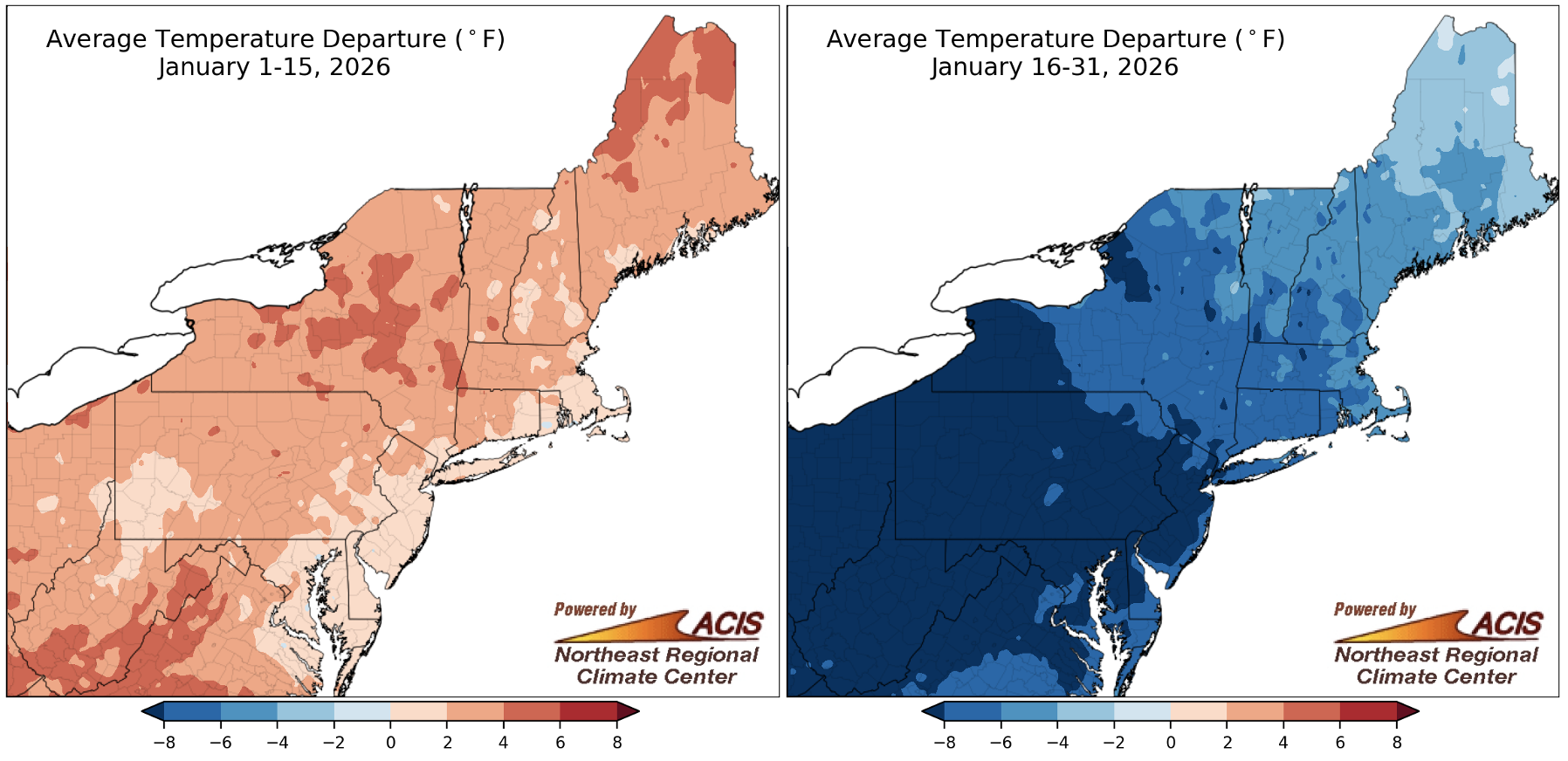
January started with above-normal temperatures (map left) but turned much colder later in the month (map right). Click to enlarge.
The first half of January was warmer than normal across the Northeast, but the second half was much colder. There was a prolonged cold period from January 23 to February 1, with high temperatures in particular being well below normal. For example, Kennedy Airport, NY, tied its record-long streak of days with a high less than 25°F at six such days from January 27 to February 1. Meanwhile, sites like Dulles Airport, VA; Harrisburg, PA; Central Park and Islip, NY; and Charleston, WV, had their second- or third-longest such streaks. Some sites were even colder. For instance, Elkins, WV; Erie and Scranton, PA; Syracuse, NY; and Worcester, MA, experienced their second- or third-longest streak of days with a high less than 20°F. For several of the sites, the streak lasted nine days.
In addition, several sites saw noteworthy streaks with lows at or below a certain threshold. For example, Beckley, WV, had 10 consecutive days with a low less than 15°F, tying its fourth-longest such streak. Similarly, Erie, PA, had its fifth-longest streak with a low less than 10°F at 10 such days, while Pittsburgh, PA, had its fifth-longest streak with a low less than 5°F at six such days.
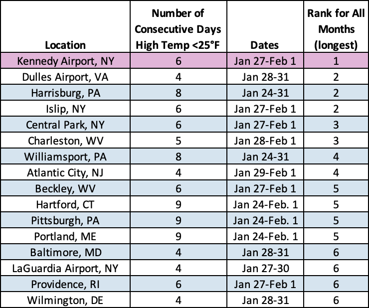
Kennedy Airport, NY, tied its longest streak of days with a high less than 25°F, while several other sites saw one of their 10 longest such streaks.

January average temperatures ranged from 6°F below normal to near normal for most of the Northeast.
With the warm start but cold end to January, average temperatures for the full month ranged from 6°F below normal to near normal for most areas, with parts of Maine being slightly above normal. The largest departures below normal were generally in the Mid-Atlantic. January average temperatures for the Northeast’s 35 major sites ranged from 5.8°F below normal in Erie, PA, to 0.1°F above normal in Caribou, ME, the only warmer-than-normal site. For several sites, this January was the coldest in over 10 years. For instance, it was the coldest January since 2014 for Washington, D.C.; Kennedy Airport, NY; and Allentown and Pittsburgh, PA.
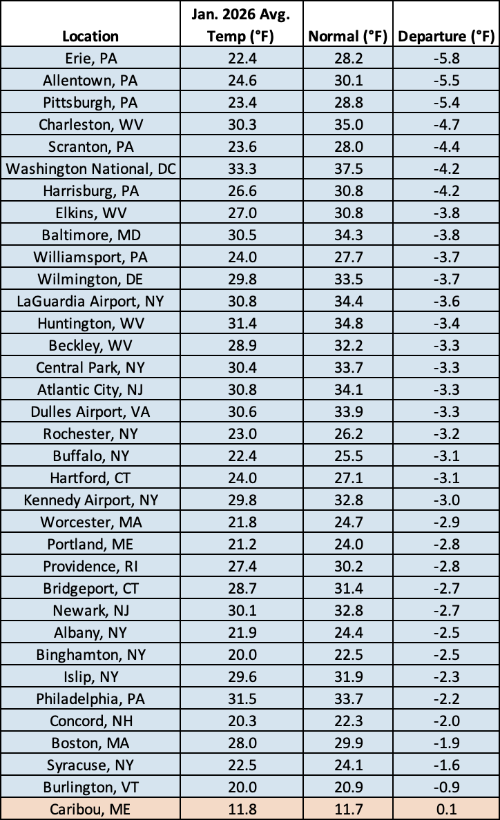
Thirty-four of the region’s 35 major sites experienced a colder-than-normal January.
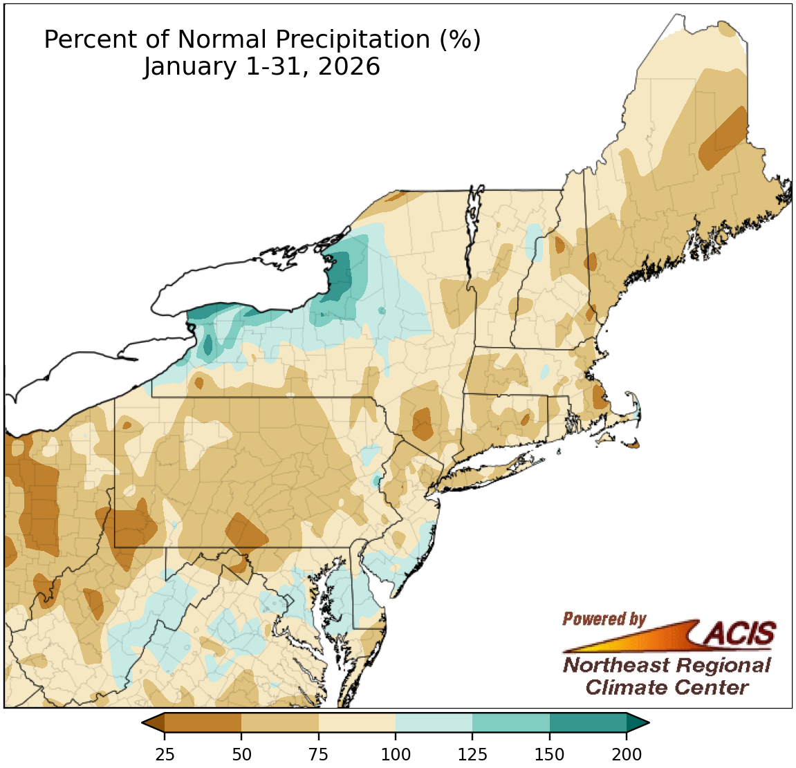
January precipitation ranged from 25% of normal to 200% of normal.
For most of the Northeast, January precipitation was below or near normal, with the driest locations seeing less than 50% of normal. However, a few places were wetter, particularly lake-effect prone areas of New York which saw up to 200% of normal precipitation. Precipitation for January at the Northeast’s 35 major sites ranged from 63% of normal in Williamsport, PA, to 129% of normal in Rochester, NY, with 28 of the sites being on the dry side of normal. One of the seven wetter-than-normal sites, Dulles Airport, VA, had its 19th-wettest January on record. There was minimal change in drought conditions during the month.
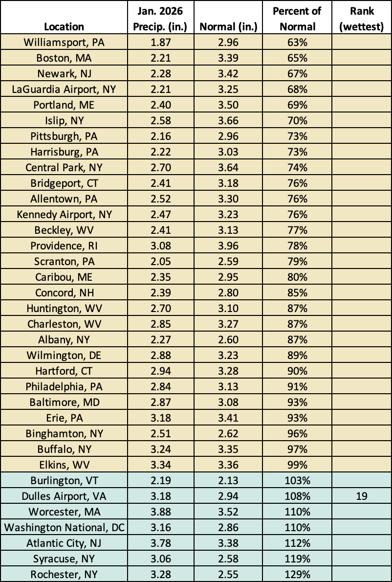
This January was the 19th wettest on record for Dulles Airport, VA, but was drier than normal for 28 of the region’s 35 major sites.
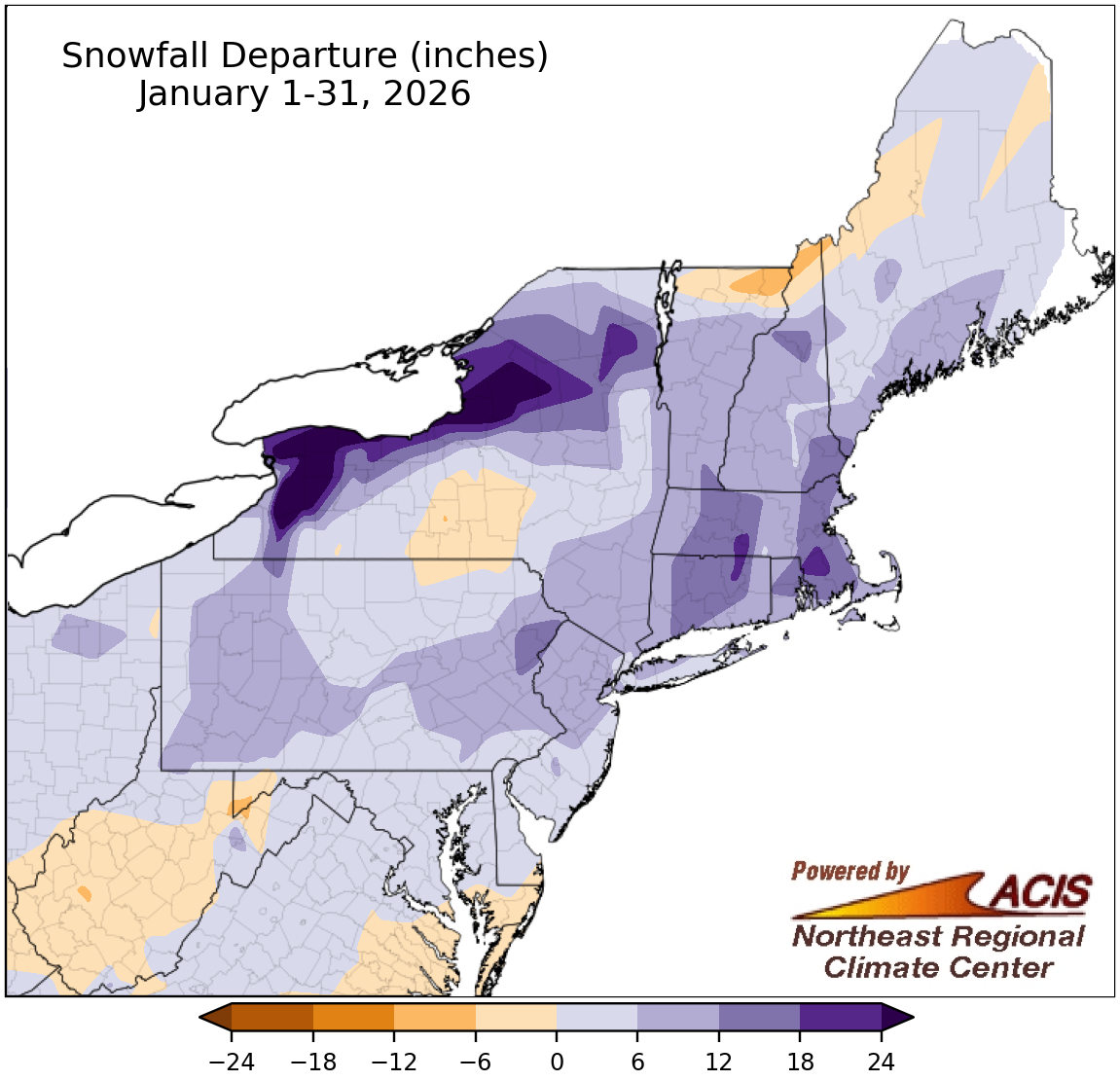
January snowfall generally ranged from six inches below normal to more than 24 inches above normal.
During January, a few areas saw snowfall deficits of generally less than six inches. However, January snowfall for most of the Northeast was near or above normal. The largest surplus of over 24 inches was found in lake-effect zones of northern and western New York, with a few sites amassing over 100 inches of snow. In fact, several sites had one of their 10 snowiest Januaries on record. For example, Lowville accumulated 67.0 inches of snow during January, qualifying as its fifth-snowiest January and seventh all-time snowiest month with mostly complete records back to 1893. At the Northeast’s 35 major sites, January snowfall ranged from 6.5 inches below normal in Charleston, WV, to 19.4 inches above normal in Worcester, MA, with 28 sites having a snowfall surplus. This January ranked among the 20 snowiest Januaries on record for 12 major sites. A late-month storm helped push snowfall totals over the normal line for multiple locations.
This January ranked among the 20 snowiest Januaries on record for 12 of the region’s 35 major sites.
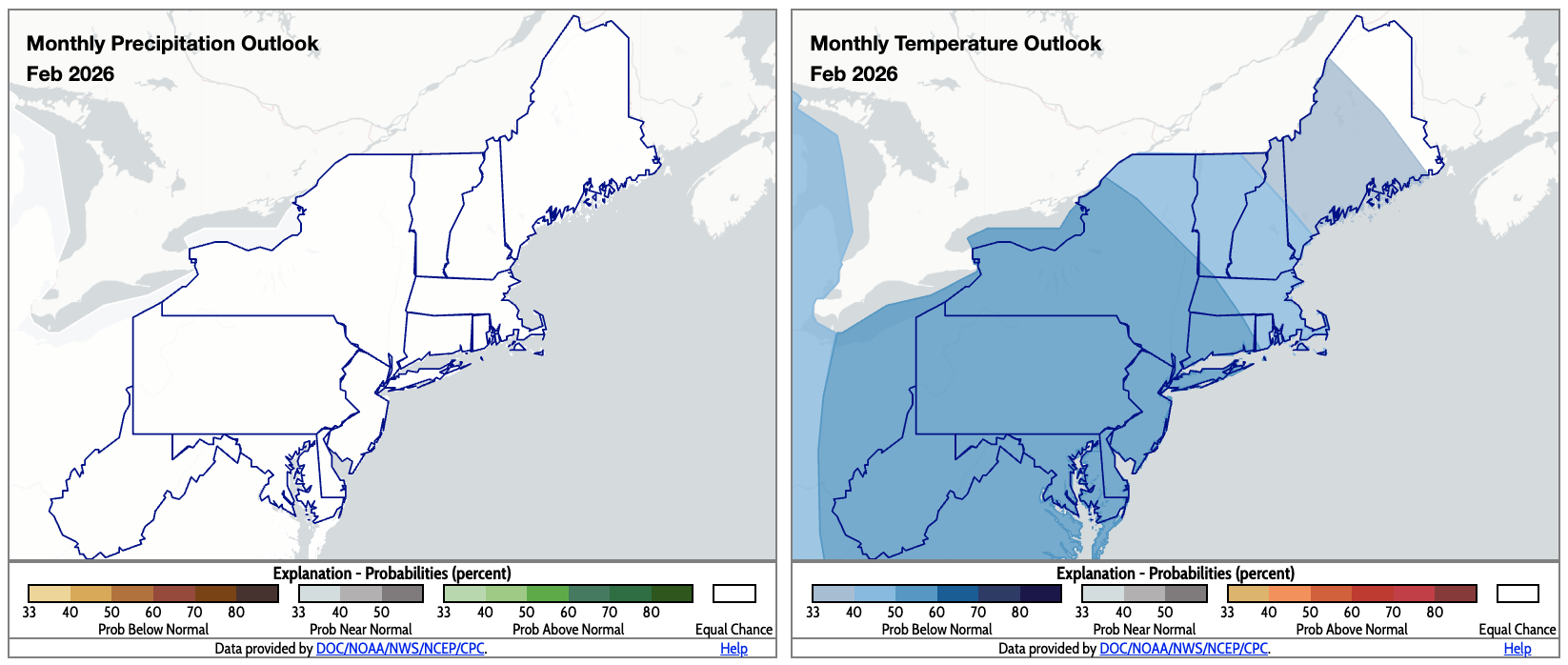
For February, the Northeast falls into the equal chances category for precipitation (map left) but below-normal temperatures are favored for most areas (map right). Click to enlarge.
February is expected to average out to be colder than normal for much of the Northeast, according to NOAA’s Climate Prediction Center. However, there were no clear signals to sway the February precipitation outlook, so the entire region has equal chances of below-, near-, or above-normal precipitation.