September - Turning Over a New Leaf
The first month of autumn started off on the cold side, with temperatures ranging from normal to more than 6°F below normal for much of the Northeast. However, the second half of the month featured a big warm up, with record-setting heat moving into the region around September 23. High temperatures pushed into the upper 80s and low 90s. These temperatures were the warmest temperatures all year for sites like Binghamton, NY, and Rochester, NY. For some sites like Caribou, ME, these temperatures were the warmest temperatures they’ve experienced so late in the calendar year. Nine major climate sites had a heat wave sometime between September 23 and 27. For sites like Burlington, VT, and Albany, NY, this was the latest heat wave in a calendar year. For Albany, it was also their first ever heat wave recorded in astronomical autumn.
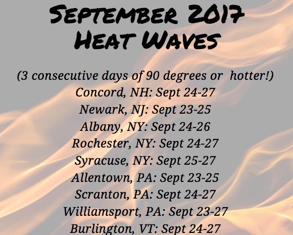
Nine major climate sites experienced a heat wave at the end of September.
With the cold start and late-month heat, September averaged out to be warmer than normal for a majority of the region. Average temperatures generally ranged from normal to more than 6°F above normal, with the warmest areas in parts of Maine. However, there were a few spots in West Virginia that were colder than normal. Thirty-three of the region’s 35 major climate sites had an above-normal average temperature for September, with 22 ranking this September among their top 20 warmest on record.
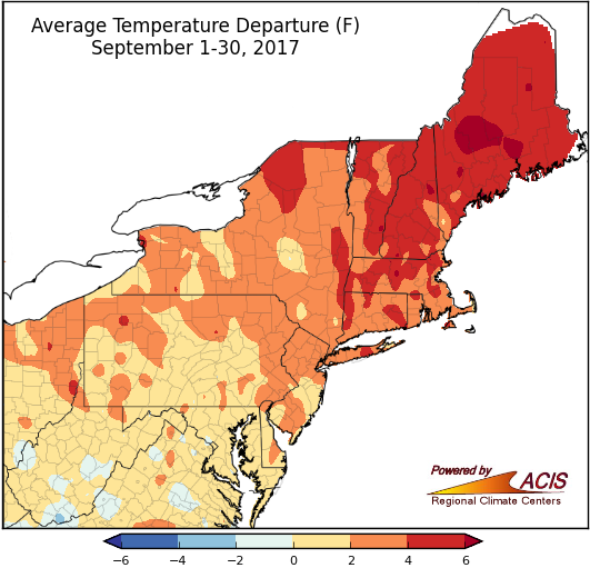
While most of the Northeast was warmer than normal in September, overall, average temperatures ranged from 2°F below normal in parts of West Virginia to more than 6°F above normal in parts of Maine.
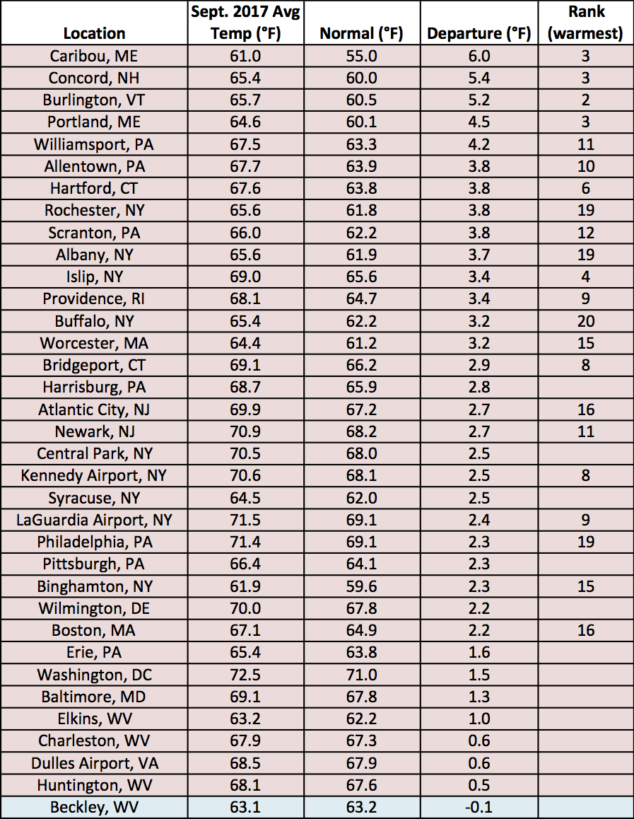
At the major climate sites, September average temperatures ranged from 0.1°F below normal in Beckley, WV, to 6.0°F above normal in Caribou, ME.
September was a drier-than-normal month, with precipitation ranging from 25% of normal to 100% of normal for most of the Northeast. There were a few spots scattered throughout the region that were wetter than normal, with the wettest areas of more than 200% of normal along Cape Cod, MA. Above-normal temperatures combined with below-normal precipitation contributed to the expansion and introduction of abnormally dry conditions in the Northeast. Thirty-one of the 35 major climate sites were drier than normal, with twelve of them ranking this September among their top 20 driest on record.
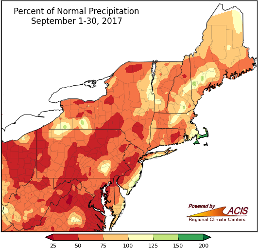
September precipitation ranged from 25% of normal to more than 200% of normal, with most areas being drier than normal.
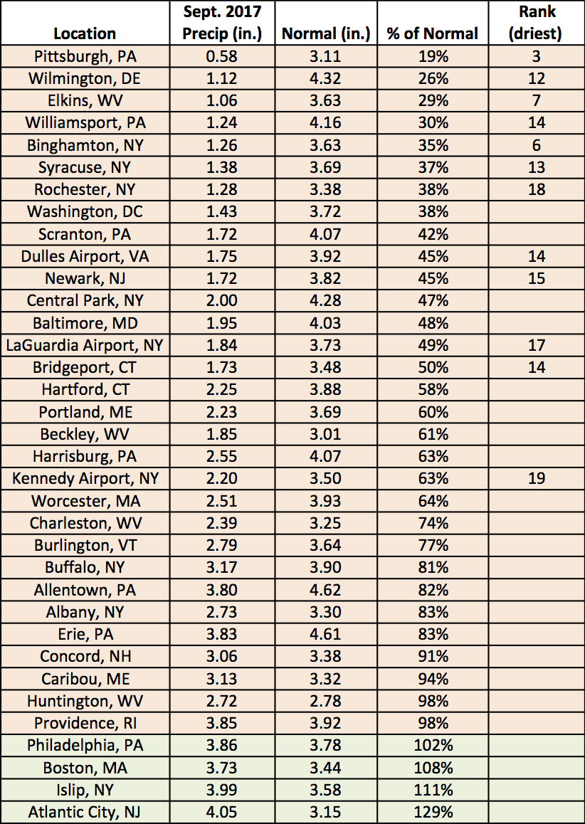
At the major climate sites, September precipitation ranged from 19% of normal in Pittsburgh, PA, to 129% of normal in Atlantic City, NJ.