Status Update - Severe Weather Edition
It has been an active year for severe weather for parts of the Northeast. For a thunderstorm to be considered severe it must produce a tornado, have winds of at least 58 mph, and/or have hail of at least 1 inch in diameter. The local National Weather Service offices are responsible for issuing warnings when severe weather is occurring or imminent. Unofficial data indicates the number of severe thunderstorm warnings issued so far this year has already surpassed the annual count for each year back to 1986 in Pennsylvania, Delaware, New Jersey, and Maryland. The Philadelphia/Mount Holly and Baltimore-Washington offices have been particularly busy, with the latter office (based on unofficial data) having issued more severe thunderstorm warnings in each of the summer months this year than any other month except one.
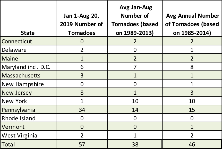
Tornadoes so far this year compared to average.
While the Northeast as a whole has seen more tornadoes than usual this year, that doesn’t necessarily hold true for each state. Pennsylvania has had more than double its average amount of tornadoes, while New Jersey is having (tied) its third most active year for tornadoes on record (since 1950). On the other hand, tornado activity in New York has been unusually quiet, with the state recording only one so far this year compared to its average of 10. June and July tend to be the most active months for tornadoes for the Northeast but that was not the case this year. Instead, April and May were extremely active. But once again, tornado activity for each month depended on the location. For instance, while April was record setting for tornadoes in Pennsylvania, July was the most active tornado month for Massachusetts and August was the most active for New Jersey.
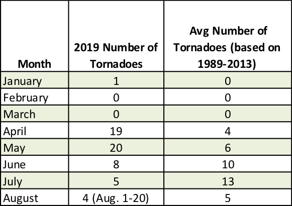
Monthly tornado count this year compared to average.