Hurricane Season (Officially) Starts Soon
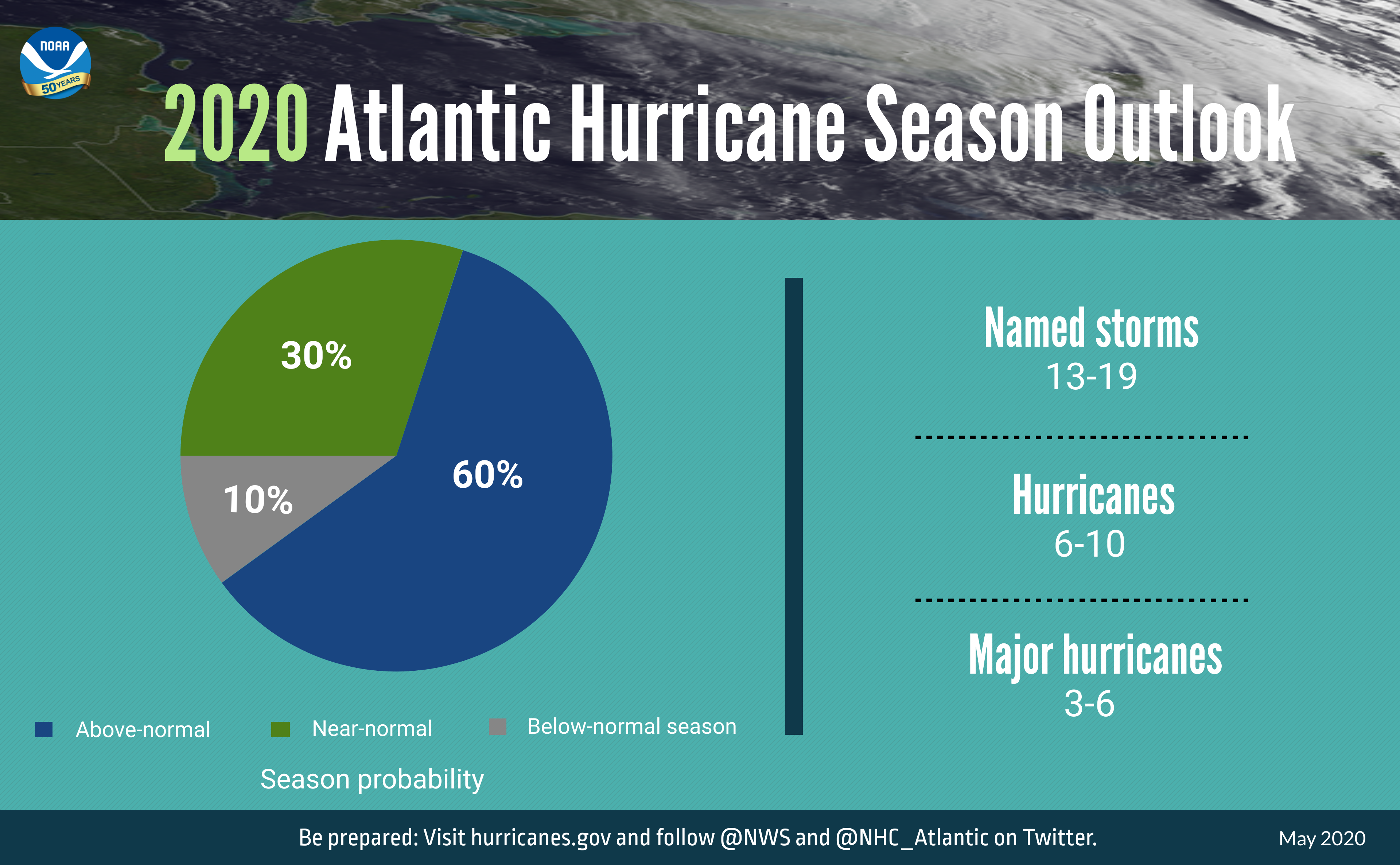
The 2020 Atlantic hurricane season is expected to more active than usual.
For the sixth consecutive year, a tropical system formed in the Atlantic basin prior to the official start of hurricane season. This year, Tropical Storm Arthur formed on May 16, kicking off what is expected to be an above-normal hurricane season. NOAA’s 2020 Atlantic hurricane outlook, which includes Arthur, calls for “a likely range of 13 to 19 named storms (winds of 39 mph or higher), of which 6 to 10 could become hurricanes (winds of 74 mph or higher), including 3 to 6 major hurricanes (Category 3, 4 or 5; winds of 111 mph or higher).” For comparison, an average season has 12 named storms, of which 6 become hurricanes, including 3 major hurricanes. The hurricane outlook does not predict the number of storms that will make landfall or the impacts the storms may have. The Atlantic hurricane season runs from June 1 to November 30, peaking from mid-August to late October when ocean temperatures are the warmest and atmospheric conditions are the most conducive to storm development.
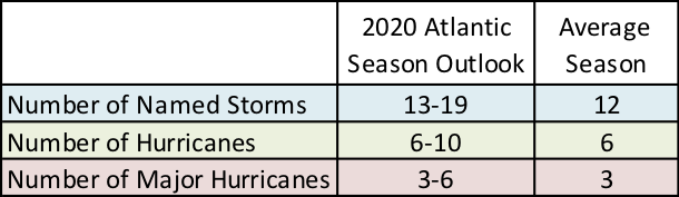
The 2020 Atlantic hurricane season forecast compared to an average season.
Last year was also an above-normal season, with 18 named storms including six hurricanes of which 3 became major hurricanes. Several of the storms affected the Northeast. In late August, a cold front and moisture from the remnants of Tropical Storm Erin dropped over 3 inches of rain in parts of New England. In early September, Hurricane Dorian, which produced catastrophic damage and numerous fatalities in the Caribbean, grazed the Northeast coastline, creating high surf, rip currents, tropical storm force winds, heavy rain, and coastal flooding. A nor’easter strengthened into Subtropical Storm Melissa and stalled off the East Coast from October 8 to 12, producing heavy rain and strong winds in eastern Massachusetts and causing high water levels and coastal flooding from Massachusetts to Maryland. Maryland’s Eastern Shore experienced major flooding, with the water level of the Chesapeake Bay at Cambridge, MD, reaching its fourth highest water level since 1980. From October 20 to 21, the remnants of tropical storm Nestor grazed the southeast corner of the region dropping up to 4 inches of rain.
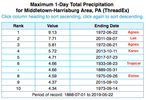
Four of the five wettest days since 1888 at Harrisburg, PA, were associated with tropical systems.
And while the Northeast experienced only glancing blows and minimal impacts from a few tropical systems in 2019, climatology shows that almost every coastal county in the Northeast has been struck by a hurricane at least once. In fact, direct strikes, tropical systems passing close by, and the remnants of tropical systems can all have major impacts including storm surge and coastal flooding, extreme rainfall and inland flooding, damaging winds, and tornadoes. For instance, Maryland’s eight tornadoes from the remnants of Hurricane Ivan in 2004 still rank among the state’s largest tornado outbreaks on record; the combination of saturated ground and rainfall from Hurricane Irene and Tropical Storm Lee in 2011 caused historic flooding, particularly in parts of Vermont, New York, and Pennsylvania; and, in 2012, Hurricane Sandy’s surge arrived near high tide, setting record-high water levels.

Flooding in New York after Tropical Storm Lee in September 2011. Image courtesy NWS Binghamton.
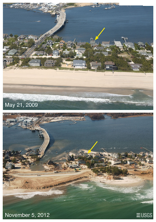
Images of Mantoloking, NJ, before and after Sandy.
It’s important to prepare before a storm arrives. For safety information and resources, go to the National Weather Service’s hurricane page - http://www.nws.noaa.gov/om/hurricane. To see if there are any active tropical systems and for a 5-day outlook, visit the National Hurricane Center’s website at https://www.nhc.noaa.gov/. If there is an approaching storm, your local National Weather Service office is a great resource for additional updates and information - https://www.weather.gov/.
An updated outlook will be issued by NOAA in August. In addition, our August webinar will feature a discussion on hurricane season and the updated outlook. You can register for that webinar using this link (make sure to choose the August webinar from the drop down menu) - https://register.gotowebinar.com/rt/5836476407379693840