First Major Storm of 2018
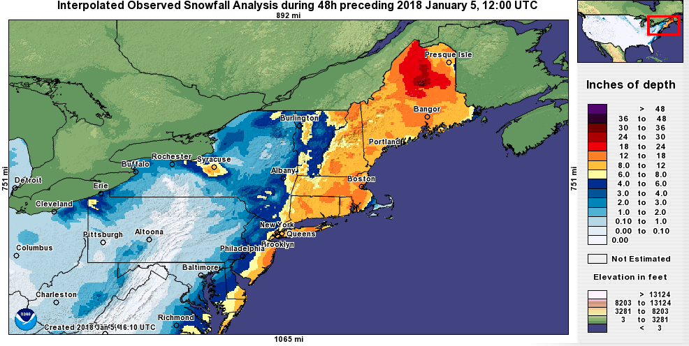
48-hour snowfall totals ending at 7 AM on January 5. Areas shaded dark orange and red received more than 12 inches of snow. Click to enlarge. Map credit: NOAA’s National Operational Hydrologic Remote Sensing Center.
A nor’easter rapidly intensified off the East Coast, blanketing (mainly coastal) areas from southern Maryland to northern Maine with heavy snow. The powerful storm produced snowfall rates of up to 3 inches per hour and thundersnow in northern Maine, eastern Massachusetts, and on Long Island. The greatest snow totals ranged from 12 to 24 inches. Below is a list of preliminary greatest storm snow totals from several National Weather Service offices as of Friday (January 5) morning.
- Caribou - 24.0 inches in Holden, ME
- Philadelphia/Mt. Holly - 18.3 inches in Berkeley Township, NJ
- Gray/Portland - 17.9 inches in Hancock, NH
- Boston/Taunton - 17.6 inches in Taunton, MA
- New York/Upton - 16.4 inches in Terryville, NY
- Burlington - 14.0 inches in Morgan, VT
In addition, 13 major climate sites set daily snowfall records on January 4. The daily snow totals ranked among the five greatest 1-day snowfalls for January at Islip, NY (third greatest); Atlantic City, NJ (third greatest); Providence, RI (fourth greatest); and Worcester, MA (fifth greatest). It's been several years since some of these sites have seen a 12+ inch snowfall. For instance, Atlantic City's last snowfall of at least 12 inches was in December 2010 and Caribou's was in December 2013.
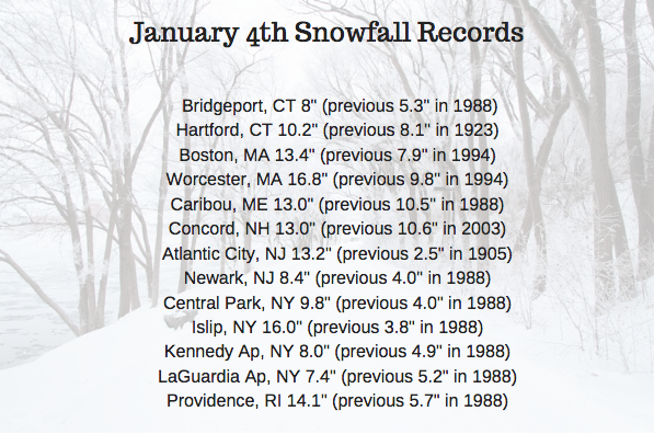
Daily snowfall records were set at 13 major climate sites. For four sites, the daily snow total ranked among the five greatest for January.
Strong winds (hurricane-force [74+ mph] in some areas) accompanied the storm, causing blizzard conditions at Block Island, RI, and whiteout conditions in many other areas. The conditions halted operations at Kennedy Airport for around 20 hours and at LaGuardia Airport for 7 hours. More than 5,000 flights were cancelled nationwide, with most in the Northeast. The strong winds also downed trees and wires, leading to power outages in the region.
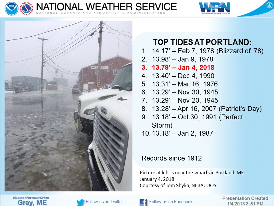
Portland, ME, had its third highest tide since 1912.
The storm contributed to high water levels and significant flooding along the New England coast. According to the Boston/Taunton National Weather Service office, Boston had its highest ever recorded tide (since 1921). In addition, Portland, ME, had its third highest tide on record (since 1912), according to the Gray/Portland National Weather Service office. Storm reports indicated some areas were inundated by up to five feet of water, with numerous impassable roads, flooded basements, and some water rescues.
Frigid air moved in behind the storm. Highs were expected to be in the single digits and teens for much of the Northeast on January 5 and 6, with wind chills falling well below zero. Several major climate sites could set new records for coldest maximum temperature on those days.
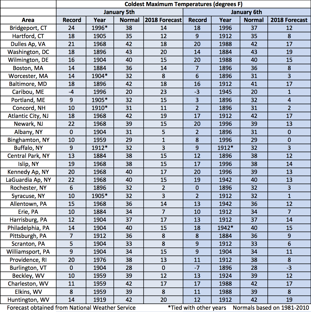
For each of the major climate sites, the record cold maximum temperature, normal maximum temperature, and forecast maximum temperature for January 5 and 6. Click to enlarge.