A Dry Start to June For Many Areas
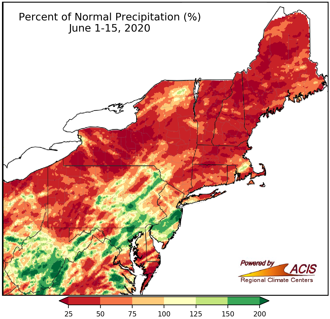
June 1-15 precipitation ranged from less than 25% of normal to more than 200% of normal, with many areas on the dry side.
The first half of June featured little precipitation for a large portion of the Northeast. Many areas in New York, New England, and western Pennsylvania saw less than 50% of their normal June 1-15 precipitation. With increasing precipitation deficits and declining streamflow, abnormal dryness expanded in some of these areas. On the other hand, a few southern locations, such as parts of West Virginia, central Maryland, eastern Pennsylvania, and the southern half of New Jersey, have seen more than 150% of normal precipitation. At the 35 major climate sites, precipitation ranged from 6% of normal in Concord, NH, to 209% of normal in Baltimore, MD. Twenty-four of the major climate sites were drier than normal, with 10 of those ranking this first half of June among their 20 driest on record. Meanwhile, four of the 11 wetter-than-normal sites ranked this June 1-15 period among their 20 wettest on record.
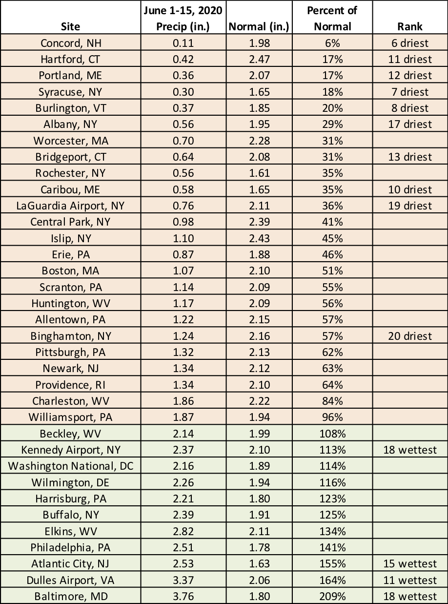
This June 1-15 period ranked among the 20 driest on record at 10 major climate sites and among the 20 wettest on record at four major climate sites.
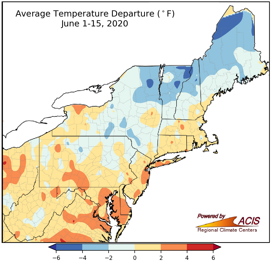
June 1-15 average temperatures ranged from 6°F below normal to 4°F above normal.
The first few days of June were unusually cold in some northern locations. For instance, Hartford, CT, tied its coldest June temperature on record with a low of 37°F on June 1, while Caribou, ME, recorded two nights with a low of 32°F or lower, tying the site’s June record. A few southern locations experienced mild temperatures on June 10, with Dulles Airport, VA, tying its warmest minimum temperature for June with a low of 74°F.
Average temperatures during the first half of June ranged from 6°F below normal to 4°F above normal, with the coldest spots generally in northeastern areas and the warmest spots generally in southeastern areas. At the 35 major climate sites, average temperatures ranged from 2.3°F below normal in Caribou, ME, to 3.4°F above normal in Baltimore, MD. Thirty-one of the major climate sites were warmer than normal, with eight of those ranking the June 1-15 period among their 20 warmest.
Short-term outlooks from NOAA’s Climate Prediction Center indicate a tilt towards warm and wet conditions for the second half of June for a majority of the Northeast.
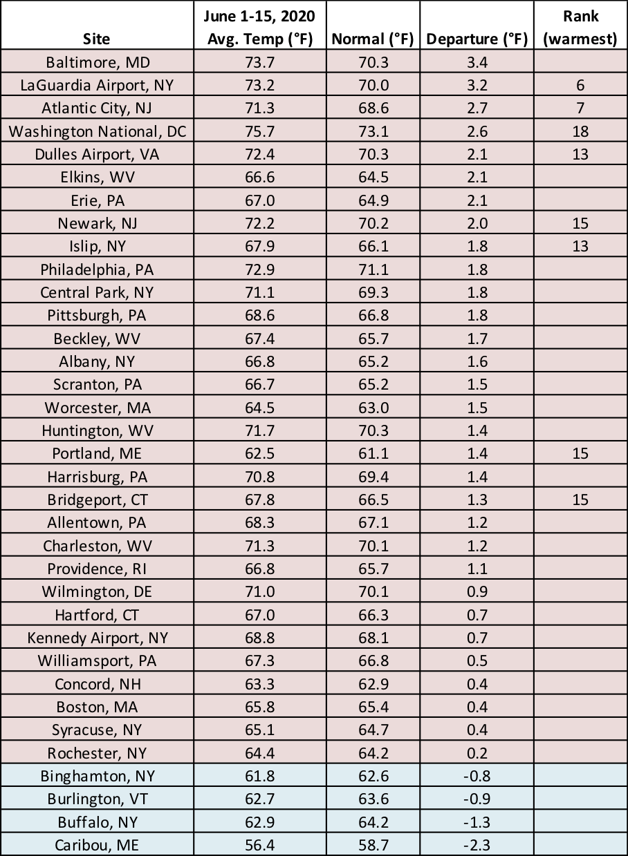
Eight major climate sites ranked this June 1-15 period among their 20 warmest on record.
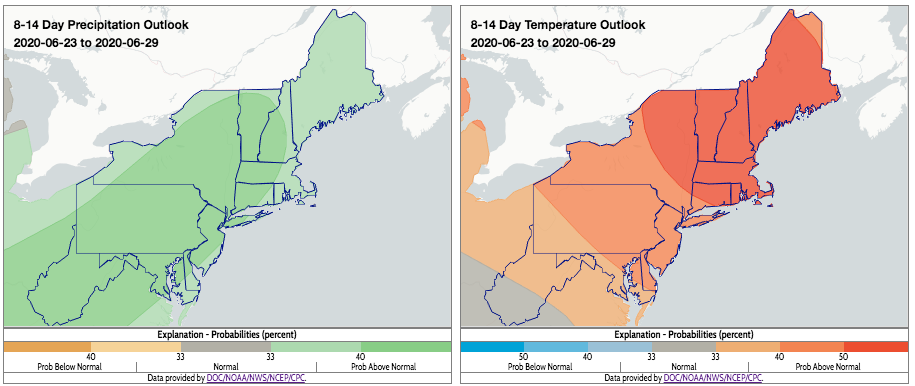
Warmer-than-normal and wetter-than-normal conditions are favored for the region for the rest of June. Click to enlarge.
The Northeast also experienced several rounds of severe weather during the first two weeks of June. On June 3, a line of intense thunderstorms with wind gusts of up to 93 mph raced across Pennsylvania and New Jersey. The event, which qualified as a derecho, caused widespread damage, downing trees and wires, knocking out power to more than 500,000 customers, and causing four deaths. There were more than 250 wind damage reports in the Philadelphia/Mt. Holly (PA/NJ) National Weather Service forecast area. Severe thunderstorms on June 10 produced an EF-2 tornado and straight-line winds of up to 80 mph in western Pennsylvania. According to the Pittsburgh (PA) National Weather Service, it was the strongest tornado in Beaver County in more than 30 years.
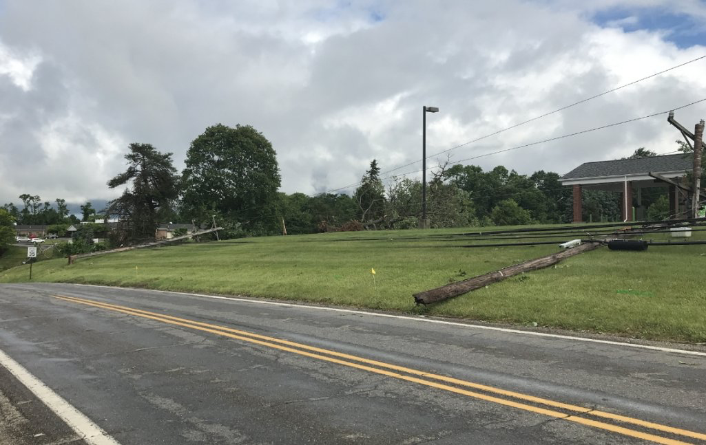
Damage from an EF-2 tornado in Beaver County, PA, on June 10. Credit: NWS Pittsburgh.