Extreme Lake-Effect Snowfall
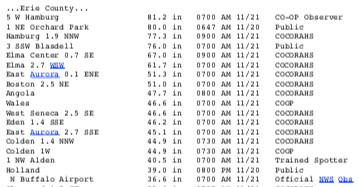
Preliminary snowfall totals for several sites in Erie County, NY. Courtesy of NWS Buffalo. Click to enlarge.
A major lake-effect snow event occurred from November 16 to 20 east of Lake Erie in western New York. Preliminary storm snowfall reports show multiple sites in Erie County accumulated over 36 inches, or 3 feet, of snowfall, with the greatest totals hovering around 80 inches, or over 6.5 feet. Those sites include a National Weather COOP site west of Hamburg with 81.2 inches, a public report of 80.0 inches in Orchard Park, a CoCoRaHS station near Hamburg with 77.3 inches, and a public report of 76.0 inches near Blasdell.
With such an extreme weather event, folks are eager to learn if the snowfall set any official records. The answer to that question will take some time and a team of people to figure out. For an element like snowfall to become an official record there is a vetting process done by a State Climate Extremes Committee, which consists of five representatives, most from the area where the potential record was set. In this case that would be the Buffalo National Weather Service (NWS), the New York State State Climate Office, the NWS Eastern Region Headquarters, the Northeast Regional Climate Center, and the National Centers for Environmental Information. Here is the current list of official snowfall records for New York State - https://www.ncei.noaa.gov/access/monitoring/scec/records/ny/snow.
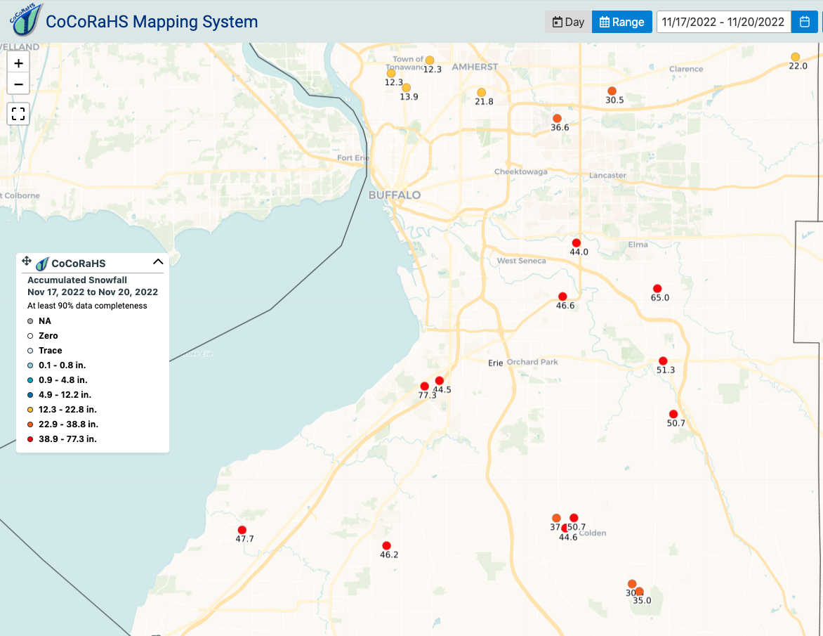
Preliminary CoCoRaHS snowfall totals in Erie County for November 17 to 20. Courtesy of CoCoRaHS. Click to enlarge.
Keeping in mind that all data from this storm are preliminary, reports are still coming in, there is a process for declaring official records, and it is important to make direct comparisons (e.g., comparing two-day snowfall to two-day snowfall and not storm total snowfall), we can make a couple of observations.
The official 24-hour snowfall record for New York stands at 50 inches on February 1, 1966, in Camden. Looking at unofficial data in the Northeast Regional Climate Center’s database, currently the greatest daily report from this storm was 46.2 inches near Elma on November 19.
The Northeast Regional Climate Center’s database shows that the greatest unofficial two-day snowfall in New York was 69.3 inches from January 5-6, 1988, at near Highmarket. The CoCoRaHS website currently shows a preliminary two-day snowfall total of 72.4 inches for November 18 to 19 near Hamburg.
The Northeast Regional Climate Center’s database shows that the greatest unofficial three-day snowfall in New York was 86.5 inches from November 18 to 20, 2014, near East Aurora. The CoCoRaHS website currently shows a preliminary three-day snowfall total of 76.0 inches for November 18 to 20 near Hamburg.
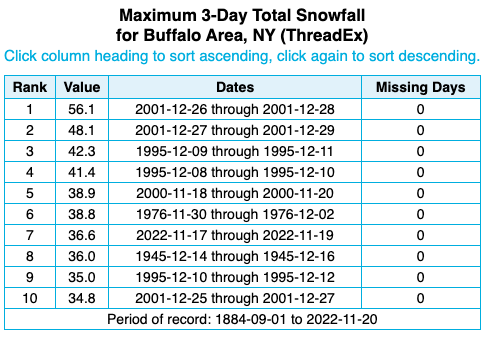
Buffalo recorded its seventh all-time largest three-day snowfall total.
At the Buffalo Airport, 36.6 inches of snow was measured from November 17 to 19, ranking as its second largest three-day snowfall total for November and seventh all-time largest three-day snowfall total, with records back to 1884. Buffalo’s two-day snowfall total of 27.2 inches ranked as its second largest two-day snowfall total for November and eighth all-time largest two-day snowfall total. Meanwhile, November 19 became the site’s second snowiest November day and its fifth all-time snowiest day with 21.5 inches of snow. As of November 20, Buffalo already had its second snowiest November on record with 36.9 inches of snow.
Whether any of the snowfall observations become a record or not, this lake-effect snowfall event was likely among some of the largest snowfall events in New York in recent history.