Records Tumble as Fall Wraps Up
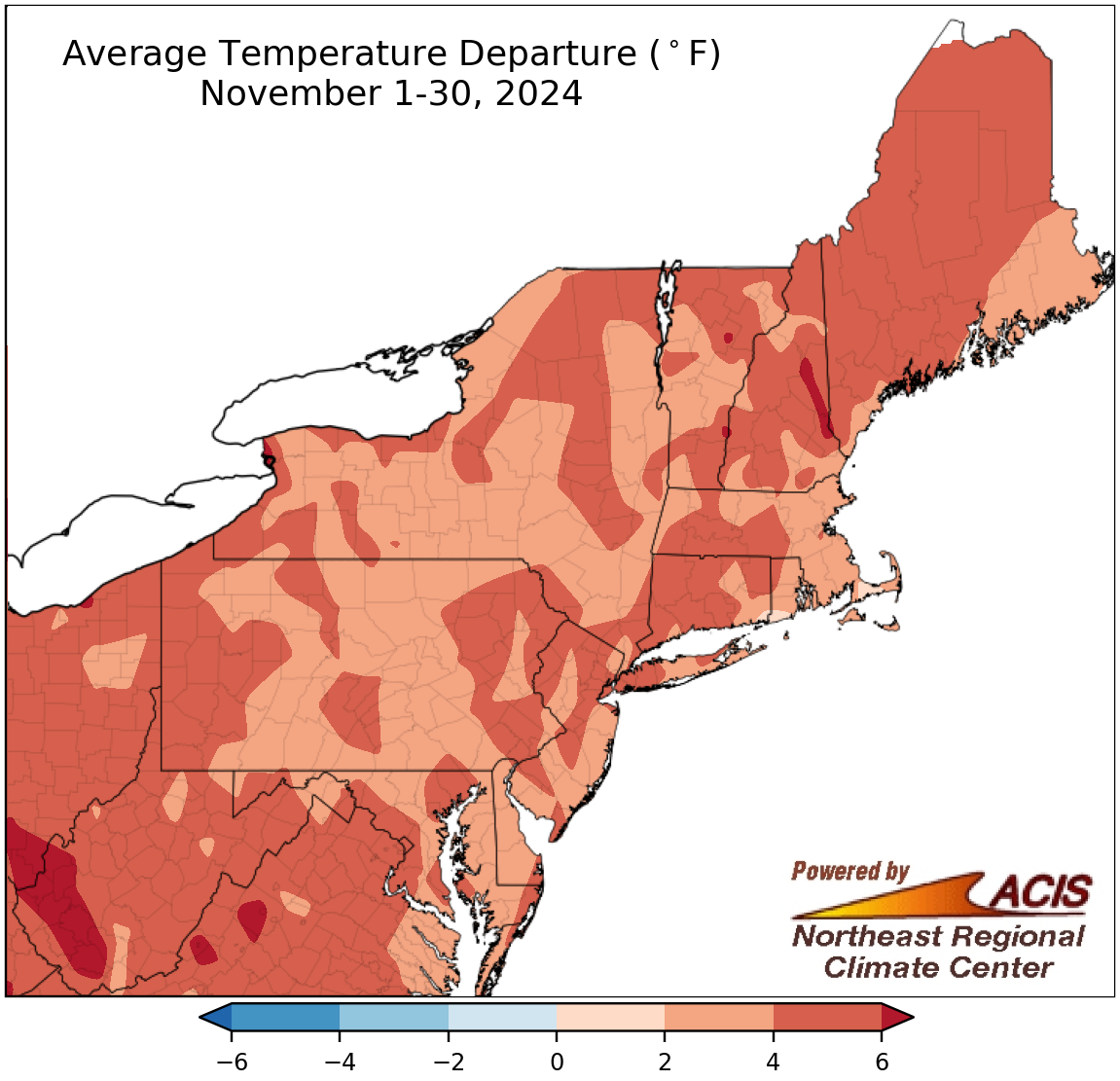
November average temperatures ranged from near normal to more than 6°F above normal.
November was another warmer-than-normal month in the Northeast, with average temperatures ranging from near normal to more than 6°F above normal. This November ranked as the warmest November on record for Hartford, CT; Caribou, ME; and Washington, DC, and was among the 20 warmest for another 31 of the region’s 35 major climate sites. Overall, November average temperatures at the major climate sites ranged from 2.7°F above normal in Scranton, PA, and Burlington, VT, to 6.1°F above normal in Huntington, WV.
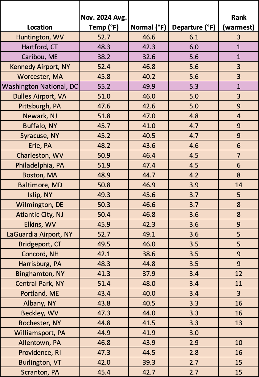
November 2024 was record warm for three major climate sites and among the 20 warmest for another 31 of the sites.
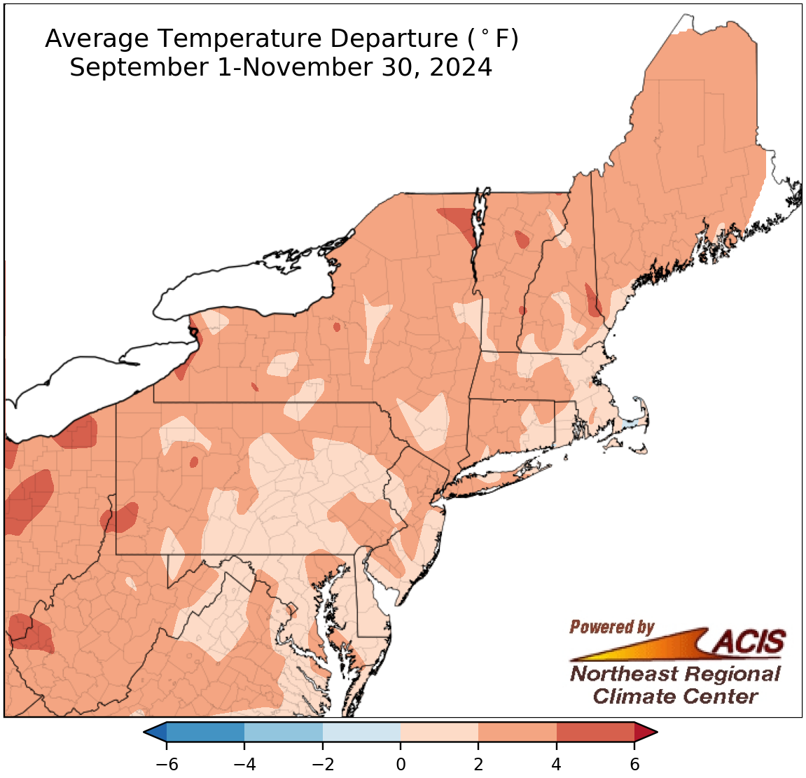
Fall average temperatures ranged from near normal to 6°F above normal.
Each month of fall featured near- or above-normal temperatures, so average temperatures for the season were up to 6°F warmer than normal. At the 35 major climate sites, this fall was record warm for Caribou, ME, and Worcester, MA, and among the 20 warmest for another 31 of the sites. Fall average temperatures for the sites ranged from 0.9°F above normal in Providence, RI, to 4.4°F above normal in Syracuse, NY, and Pittsburgh, PA.
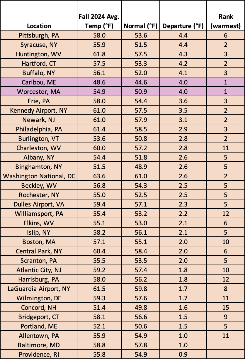
This fall was record warm for two major climate sites and among the 20 warmest for another 31 of the sites.
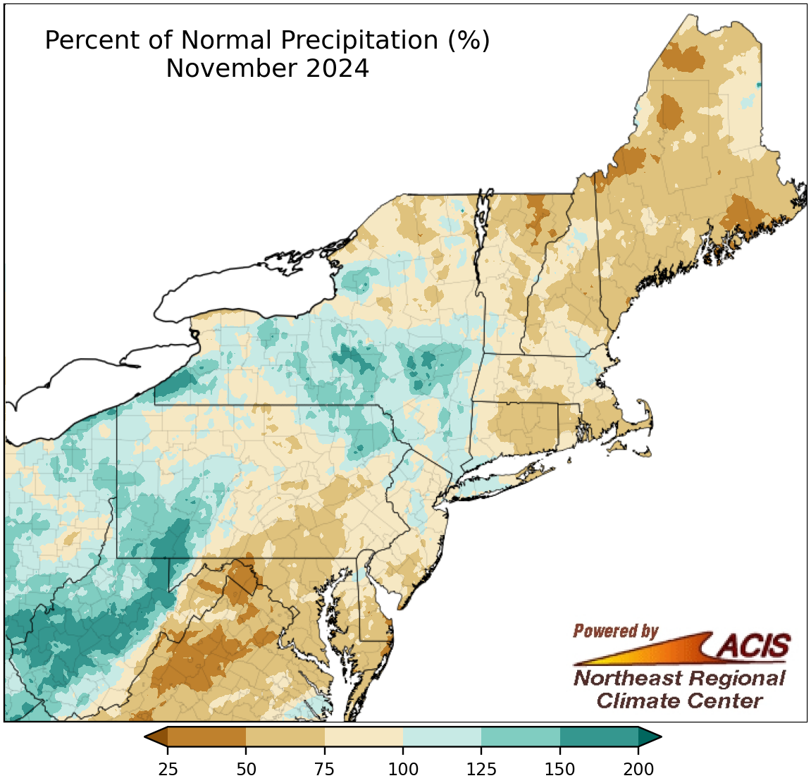
November precipitation ranged from 25% of normal to 200% of normal.
The first half of November was quite dry for many areas, but the second half featured a few storms that pushed some locations to the wet side of normal. November precipitation ranged from less than 50% of normal in places like eastern West Virginia and coastal Maine to over 150% of normal in places like central West Virginia and southwestern Pennsylvania. Precipitation for November at the region’s 35 major climate sites ranged from 59% of normal at Dulles Airport, VA, the site’s 17th driest November, to 155% of normal in Scranton, PA, with 23 sites being drier than normal. However, this November ranked among the 20 wettest for four major climate sites including Scranton. The wetter weather during the second half of the month helped relieve drought in interior locations and paused conditions from deteriorating further in coastal areas.
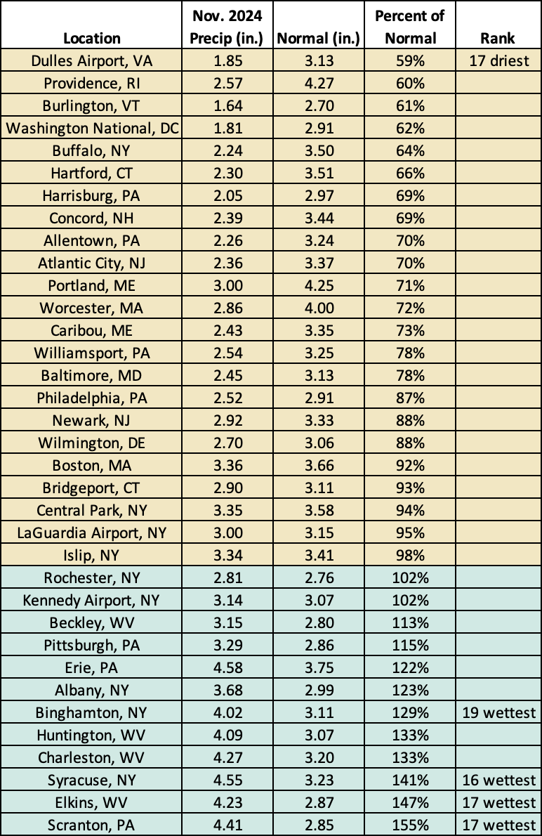
This November was the 17th driest for Dulles Airport, VA, but ranked among the 20 wettest for four other major climate sites.
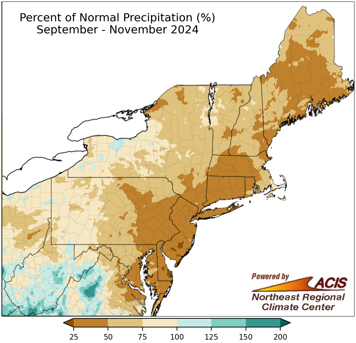
Fall precipitation ranged from 25% of normal to 150% of normal.
Much of the Northeast saw drier-than-normal conditions from September through the first half of November, with October becoming the all-time driest month on record for multiple sites. This pushed the fall season to be drier than normal for many areas. Fall precipitation ranged from 25% of normal in coastal areas to 150% of normal in parts of West Virginia. This fall was the driest fall on record for Wilmington, DE; Hartford, CT; Allentown, PA; Newark, NJ; and Kennedy Airport, NY, and was among the 20 driest for another 17 of the region’s 35 major climate sites. Overall, fall precipitation ranged 27% of normal in Atlantic City, NJ, and Wilmington, DE, to 108% of normal in Elkins and Beckley, WV, with 32 sites being drier than normal.
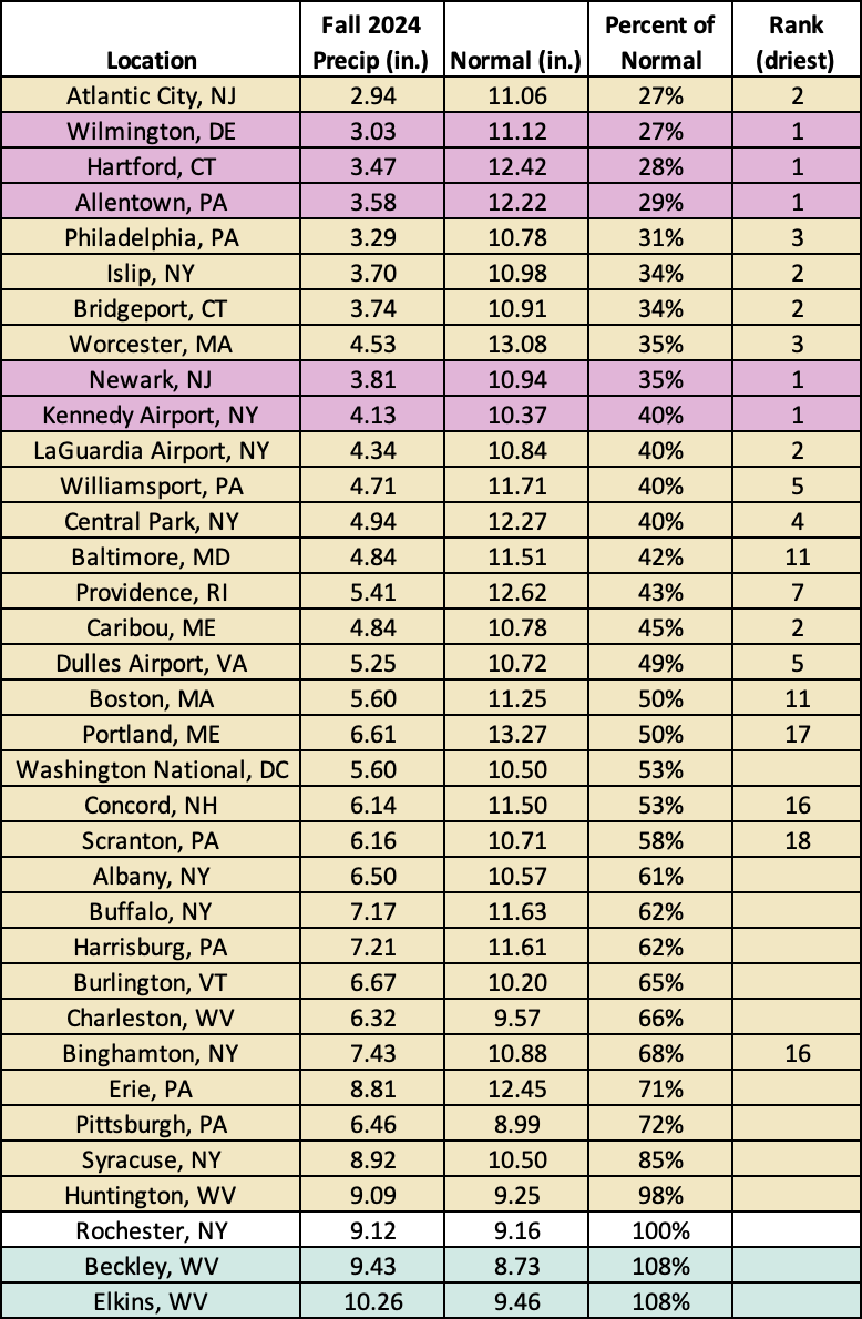
This fall was the driest on record for five major climate sites and among the 20 driest for another 17 of the sites.
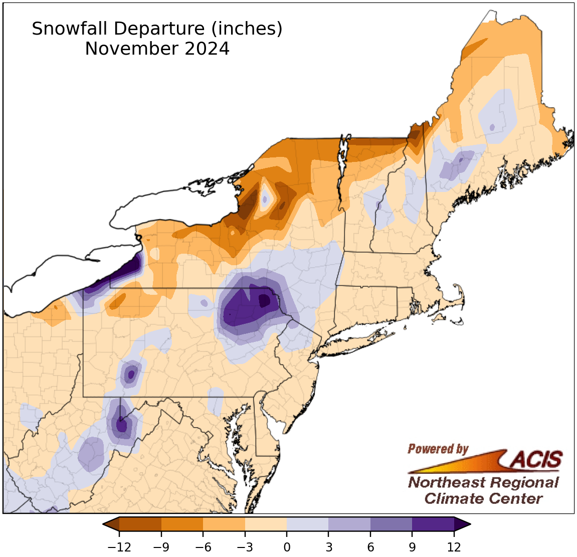
November snowfall ranged from more than 12 inches below normal to more than 12 inches above normal.
While November snowfall was within 3 inches of normal for much of the region, it did range from more than 12 inches below normal in places like northern New York to more than 12 inches above normal in places like northeastern Pennsylvania. At the region’s 35 major climate sites, November snowfall ranged from 9.6 inches below normal in Syracuse, NY, to 14.6 inches above normal in Erie, PA, with 29 sites seeing less snowfall than normal. This November was among the 20 least snowy for two sites but among the 20 snowiest for three sites. It was the first time since records began in 1871 in Rochester, NY, that the site did not record even a trace of snowfall during November. However, not far to the west, portions of western New York and northwestern Pennsylvania were experiencing a major lake-effect snowfall event as the month came to a close.
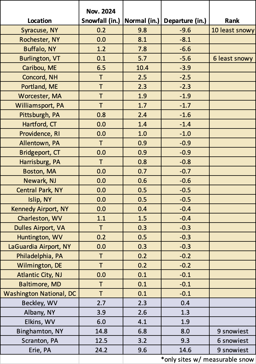
This November was among the 20 least snowy for two sites but among the 20 snowiest for three sites.
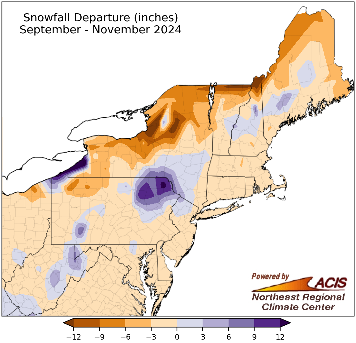
Fall snowfall also ranged from more than 12 inches below normal to more than 12 inches above normal.
Driven by November conditions, the fall season featured a range of snowfall from more than 12 inches below normal to more than 12 inches above normal, with many areas being within 3 inches of normal. Again, some northern areas had the largest deficits, while lake-effect areas of northwestern Pennsylvania and parts of western New York had the largest surpluses. Fall snowfall at the 35 major climate sites ranged from 9.8 inches below normal in Syracuse, NY, to 14.5 inches above normal in Erie, PA, with 30 sites seeing below-normal snowfall. This fall ranked among the 20 least snowy for three major climate sites but among the 20 snowiest for three other sites. Similar to November, it was the first time since records began in 1871 in Rochester, NY, that the site did not record even a trace of snowfall during the fall season.
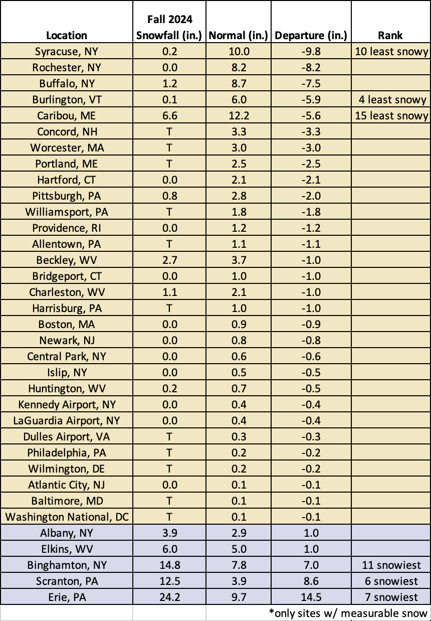
Fall 2024 ranked among the 20 least snowy for three major climate sites but among the 20 snowiest for three other sites.
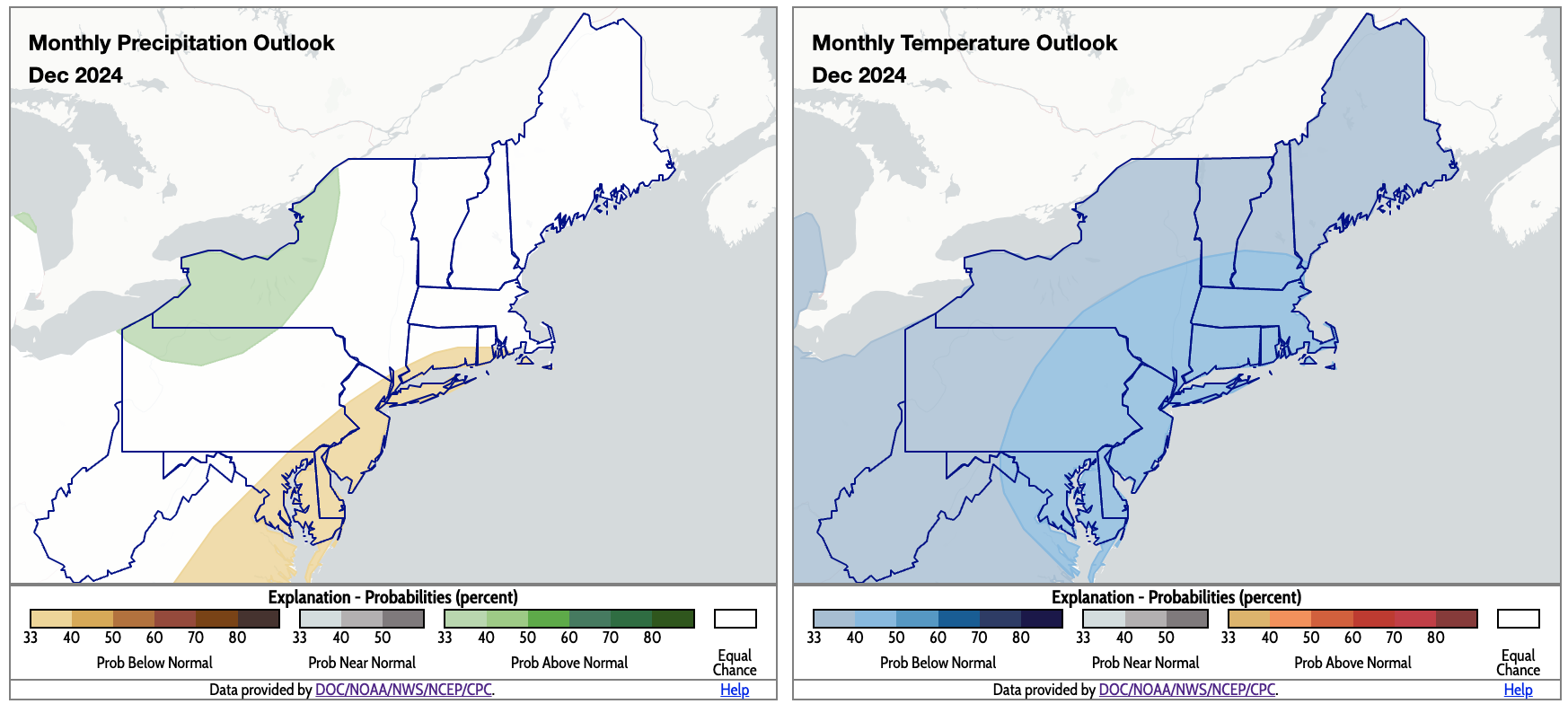
December is expected to be drier than normal for some coastal areas but wetter than normal for some interior spots. The entire region is expected to be cooler than normal. Click to enlarge.
According to NOAA’s Climate Prediction Center, there’s an increased likelihood of drier-than-normal conditions for December in coastal areas from Maryland to Maine. However, an increased likelihood of wetter-than-normal conditions for an interior area from northern Pennsylvania to northern New York, tied to lake-effect precipitation. There is a tilt toward cooler-than-normal weather for the entire Northeast for December, driven by an expected chilly start to the month.