A July for the Record Books
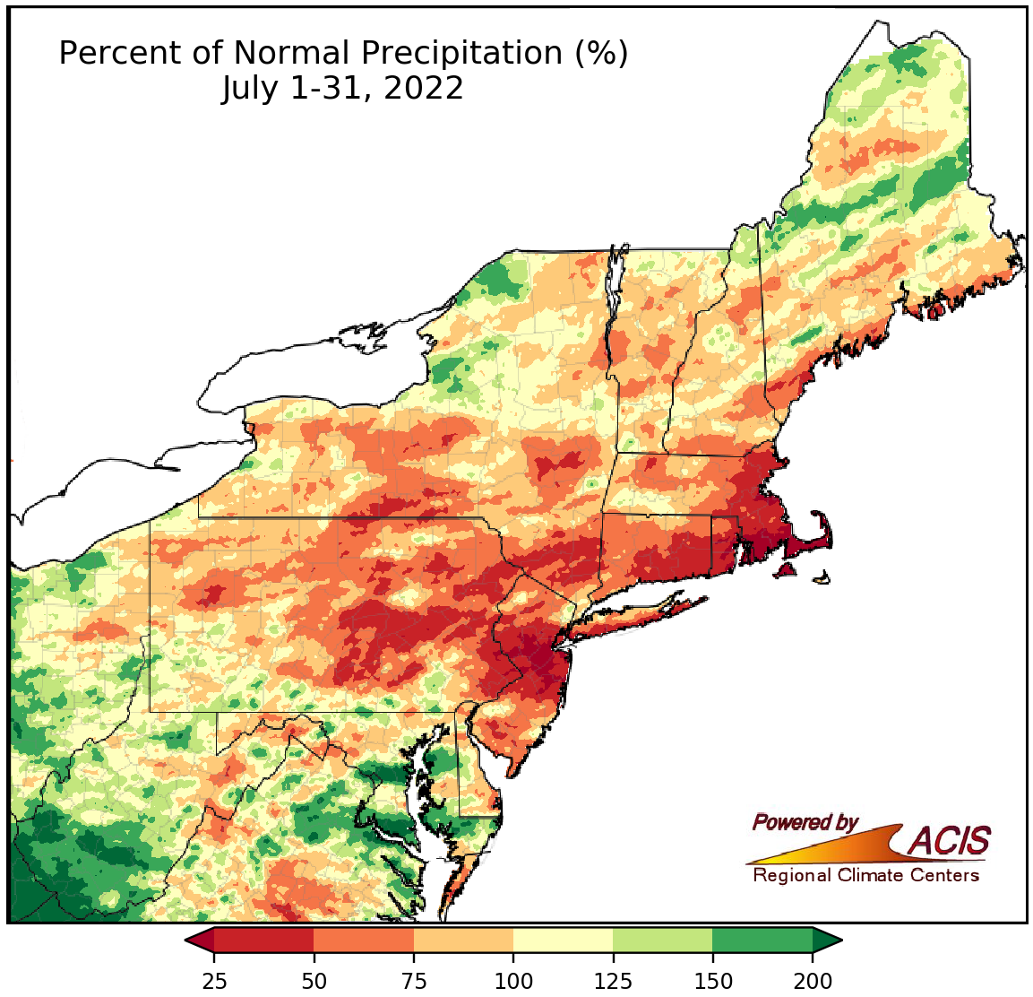
July precipitation ranged from less than 25% of normal to more than 200% of normal.
Much of the Northeast saw below- or near-normal rainfall during July, with the driest locations including southeastern Massachusetts and central New Jersey seing less than 25% of normal. In fact, this July was the driest July on record for Newark, NJ, which saw 12% of normal, and ranked as the site’s 19th all-time driest month on record. Overall, 25 of the Northeast’s 35 major climate sites were drier than normal with July precipitation at those sites ranging from 12% of normal in Newark to 99% of normal in Central Park, NY. Eight of the sites experienced one of their 18 driest Julys on record. In addition, this July became Providence RI’s 13th all-time driest month on record. Below-normal precipitation allowed drought and abnormal dryness to expand and intensify across the Northeast during the month. The dry conditions led to water restrictions, stressed crops, and increased fire risk.
However, there were a couple of areas that experienced a wetter-than-normal July, with some spots including southern West Virginia and southern Maryland seeing more than 200% of normal rainfall. In fact, Beckley, Charleston, and Huntington in West Virginia each saw over 9 inches of rain this July, ranking among their six wettest Julys on record and among their 10 all-time wettest months on record. Two additional sites ranked this July among their 14 wettest Julys on record. July precipitation at the nine wetter-than-normal major climate sites ranged from 106% of normal in Atlantic City, NJ, to 185% of normal in Charleston and Huntington, WV. Multiple counties in southern West Virginia experienced flash flooding due to heavy rain.
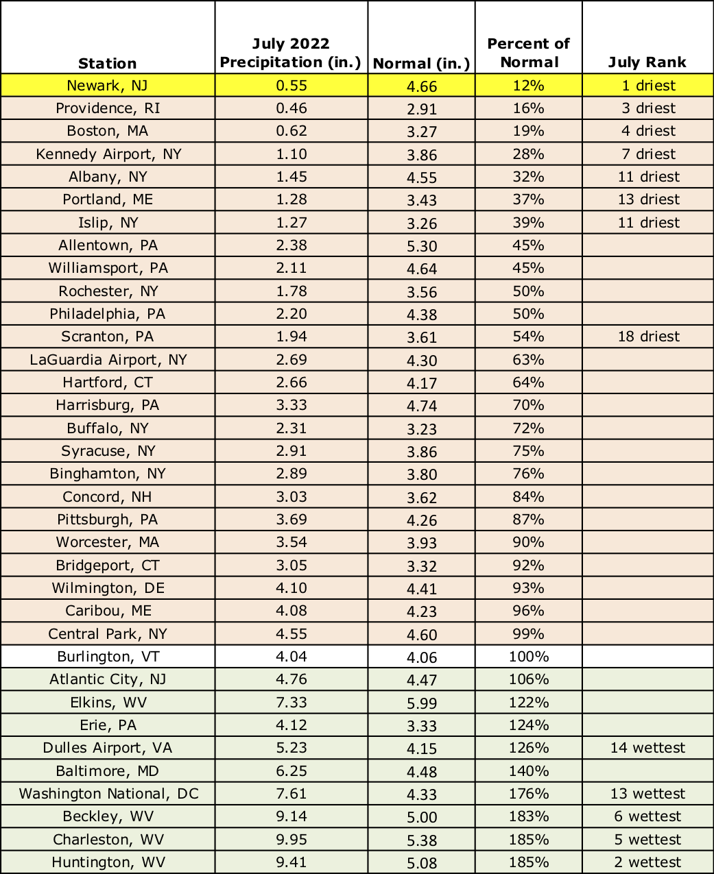
This July ranked as Newark, NJ’s driest July on record and among the 18 driest Julys at seven additional sites. However, this July was among the 14 wettest at five other sites, including Huntington, WV, which had its second wettest July.
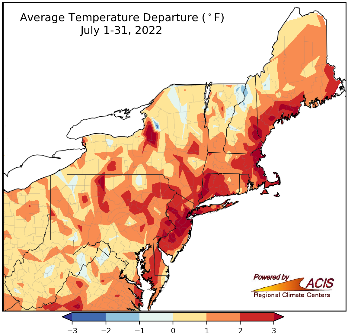
July average temperatures ranged from 1°F below normal to more than 3°F above normal.
July average temperatures ranged from near normal to more than 3°F warmer than normal, with the greatest departures above normal generally in coastal areas from New Jersey to Maine. Thirty-three of the 35 major climate sites experienced a hotter-than-normal July, with average temperatures for all of the sites ranging from 0.4°F below normal in Erie, PA, to 4.4°F above normal in Newark, NJ. This July ranked among the 20 hottest Julys on record for 25 major climate sites including Newark and Philadelphia, PA, which each had their second hottest July. In addition, this July ranked among the 20 all-time hottest months on record at 21 of the sites, with Newark and Philadelphia also having their second all-time hottest month on record.
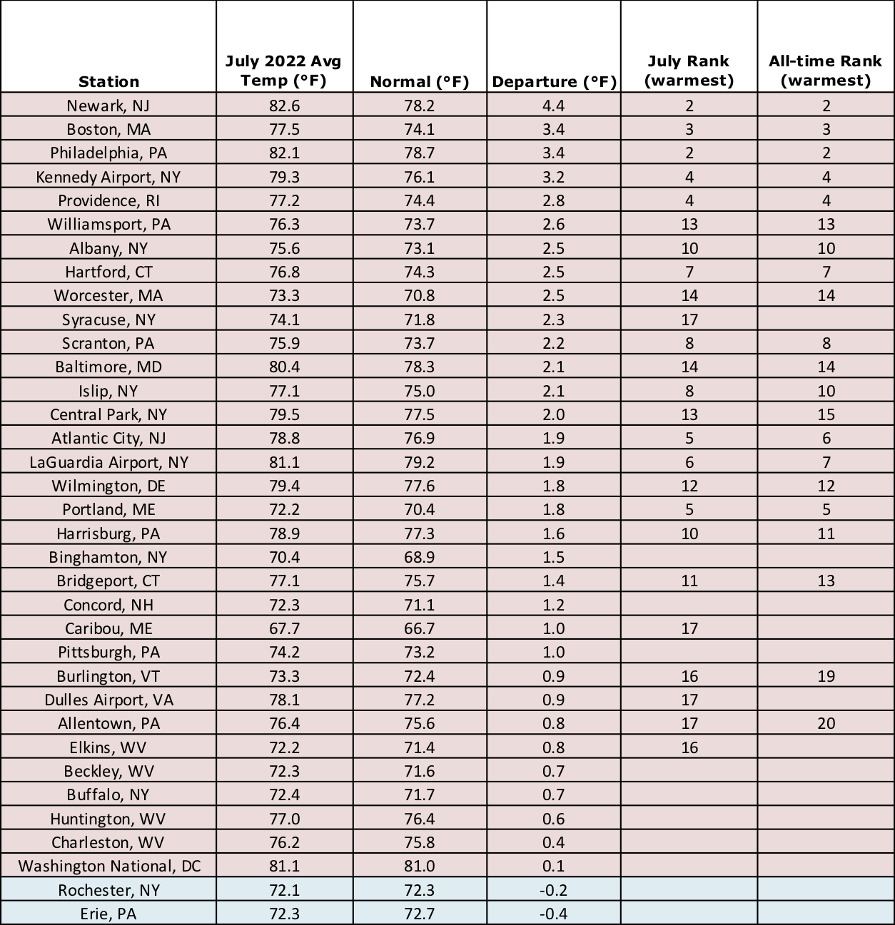
This July ranked among the 20 hottest Julys and all-time hottest months at more than 20 major climate sites.
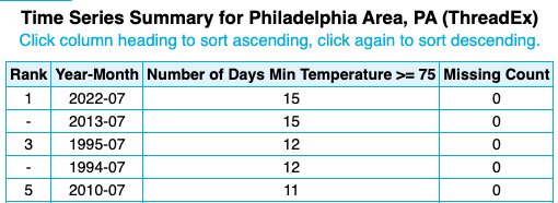
Philadelphia, PA, had 15 days with a low at or above 75°F, tying as the greatest for any July and month on record at the site.
This July featured an unusually large number of days with highs at or above 90°F and lows at or above 70°F, particularly during a heatwave from July 19-25. In fact, the number of days meeting those thresholds this July ranked among the 10 greatest for several sites. For instance, Philadelphia, PA, recorded 15 days with a low at or above 75°F, tying as the greatest for any July and month on record at the site. The consecutive number of days meeting those thresholds during July was also impressive. For instance, Newark, NJ, had five straight days with a high of at least 100°F for the first time on record, while Philadelphia and Kennedy Airport, NY, set/tied records for longest streak of days with a low at or above 75°F.
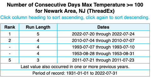
Newark, NJ, had five straight days with a high of at least 100°F for the first time on record.
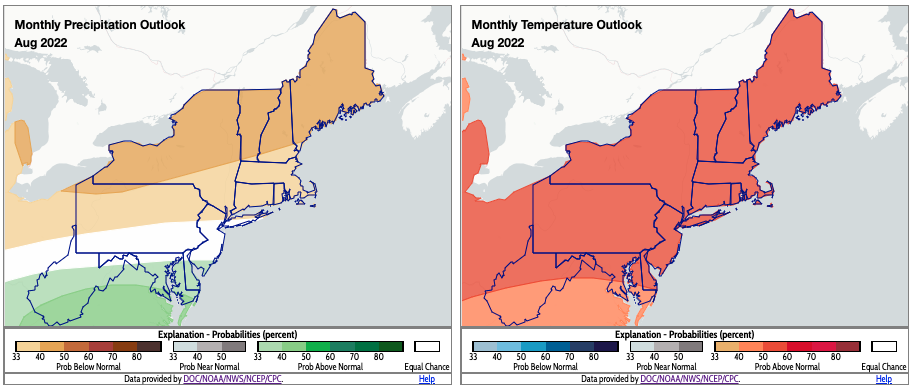
August could be drier than normal (shaded tan) and warmer than normal (shaded orange) for parts of the Northeast. Click to enlarge.
According to NOAA’s Climate Prediction Center, there’s a tilt toward drier-than-normal conditions in August for New York, New England, northern New Jersey, and the northern two-thirds of Pennsylvania. However, there’s a tilt toward wetter-than-normal conditions for southern New Jersey and much of Delaware, Maryland, and West Virginia. Equal chances of below-, near-, or above-normal precipitation were predicted for areas in between. The Climate Prediction Center favors above-normal temperatures for August for the entire Northeast.