The Winter That Wasn’t
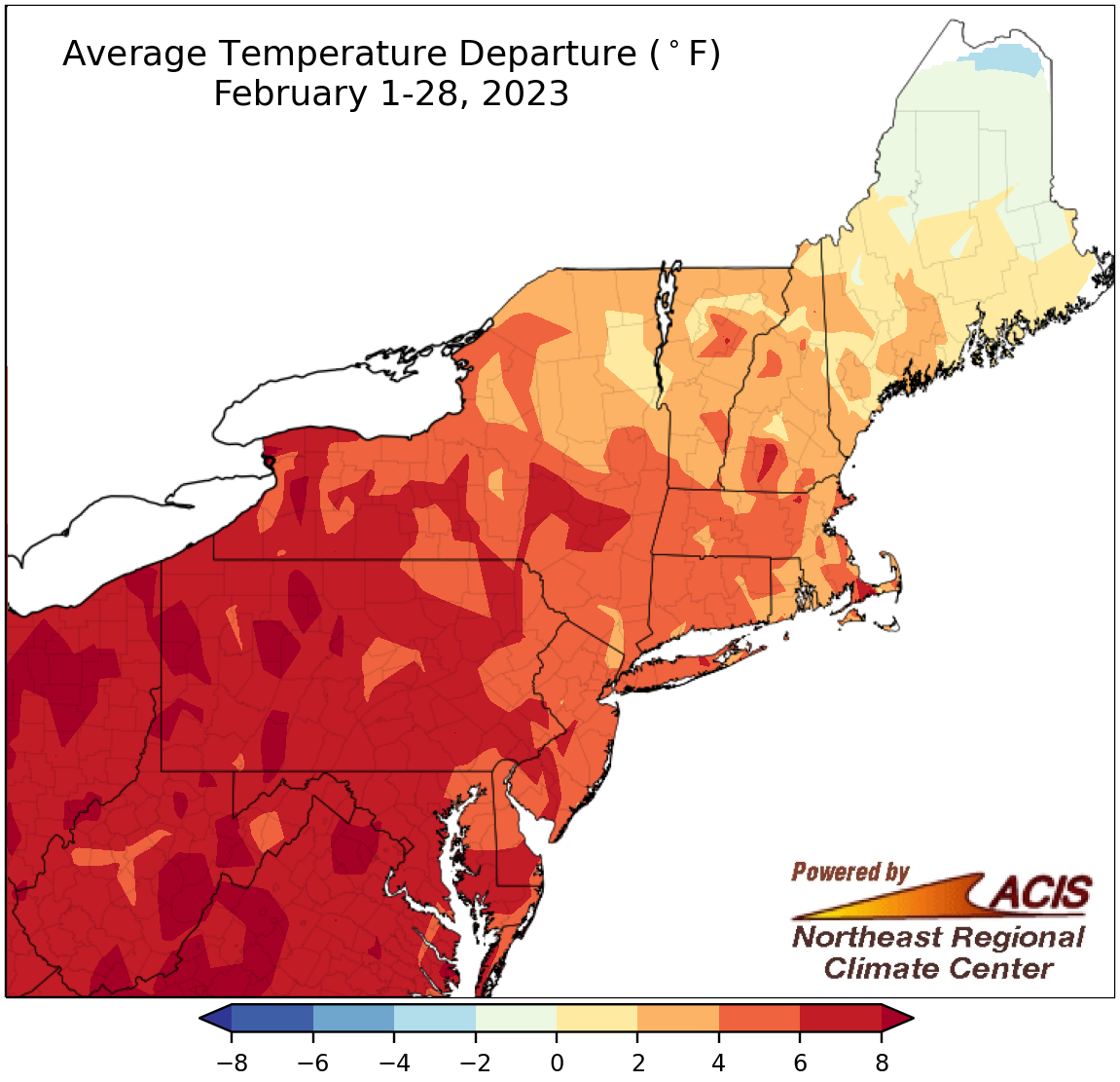
February average temperatures ranged from near normal to more than 8°F above normal for most of the Northeast.
February was another warmer-than-normal month for a majority of the Northeast, with most of the region seeing average temperatures that ranged from near normal to more than 8°F above normal. However, temperatures in northern Maine were as much as 2°F below normal. At the 35 major climates sites, this February was the warmest on record for Baltimore, MD, and ranked among the 20 warmest for another 31 of the sites. Overall, February average temperatures ranged from 1.8°F below normal in Caribou, ME, the lone cooler-than-normal site, to 8.4°F above normal in Huntington, WV, which saw its second warmest February.
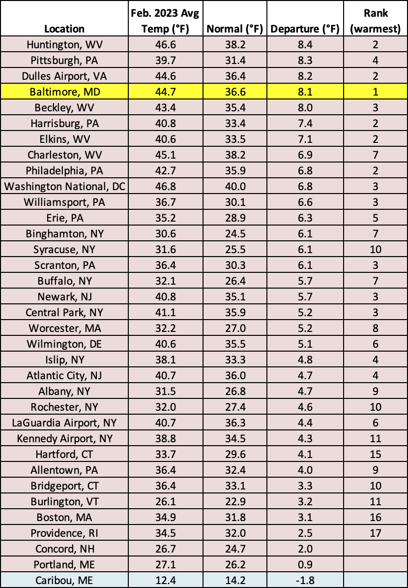
This February was record warm for Baltimore, MD, and among the 20 warmest for another 31 major climate sites.
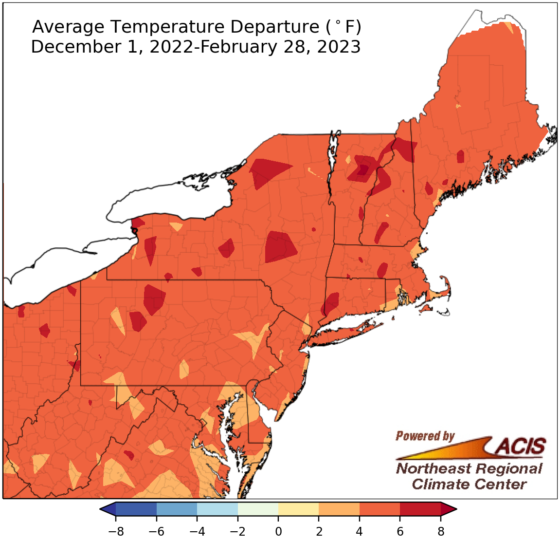
Winter average temperatures ranged from 2°F to 8°F warmer than normal.
After a variable December, record or near-record warm January, and unusually warm February, the entire Northeast experienced a warmer-than-normal winter, with average temperatures from 2°F to 8°F above normal. At the 35 major climate sites, this winter was the warmest on record for Worcester, MA, and Dulles Airport, VA, and ranked among the 10 warmest for all other sites except Erie, PA, (14th warmest). Winter average temperatures ranged from 3.4°F above normal in Providence, RI; Portland, ME; and Allentown, PA, to 6.3°F above normal in Worcester.
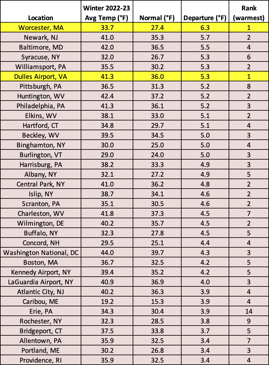
This winter was record warm for Worcester, MA, and Dulles Airport, VA, and ranked among the 10 warmest for all other sites except Erie, PA.
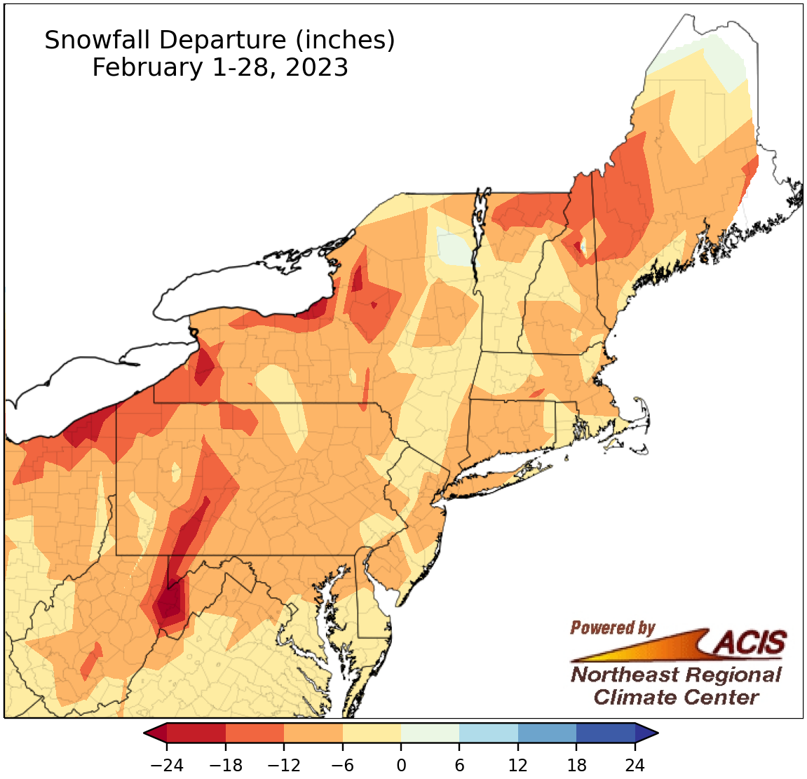
February snowfall ranged from more than 24 inches below normal to near normal for much of the Northeast.
A majority of the Northeast had snowfall deficits when February wrapped up, with the largest deficits of more than 24 inches in higher elevations of eastern West Virginia. The general exception was northern Maine, which saw a snowfall surplus of up to 6 inches. February 2023 was the least snowy on record for Pittsburgh and Harrisburg, PA, and was among the 20 least snowy for another 16 of the 35 major climate sites. February snowfall at the major climate sites ranged from 17.7 inches below normal in Erie, PA, to 2.8 inches above normal in Caribou, ME, the only site to be snowier than normal.
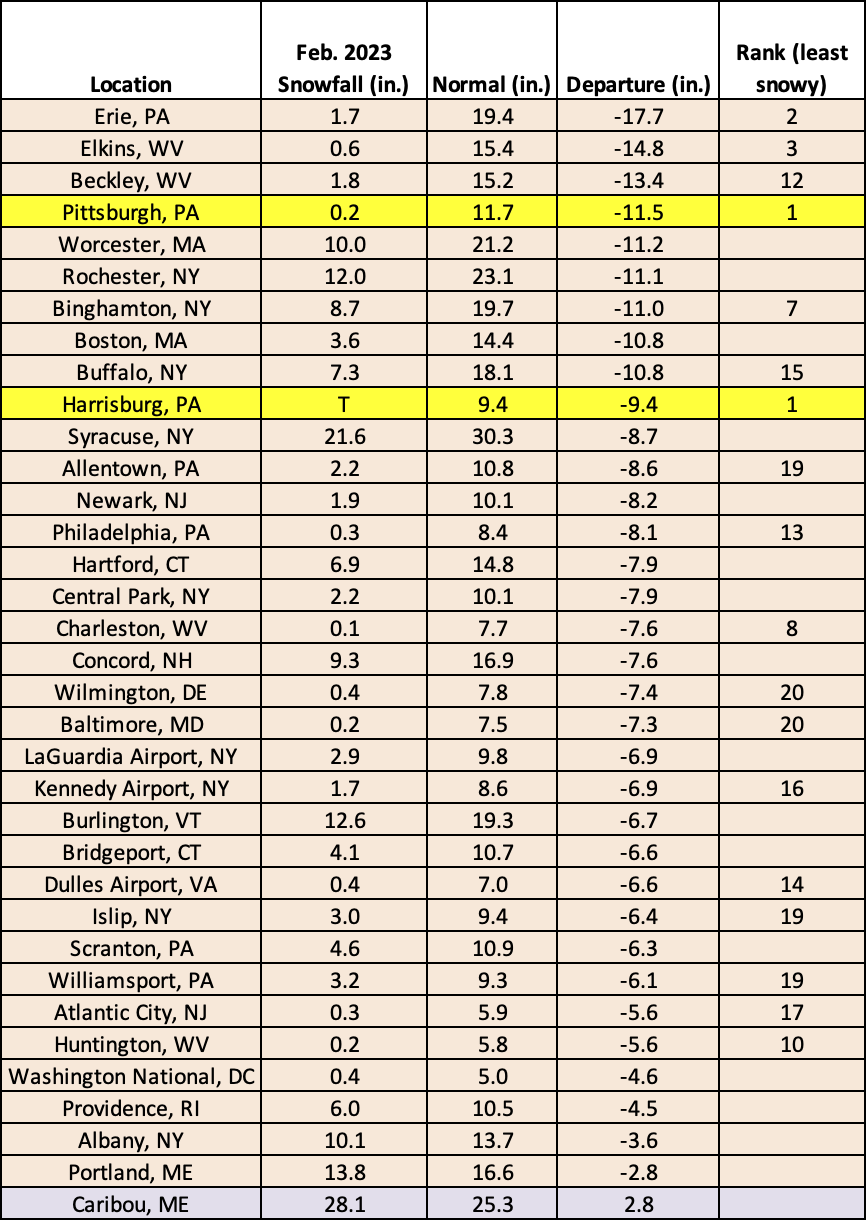
This February was the least snowy on record for Pittsburgh and Harrisburg, PA, and among the 20 least snowy for another 16 major climate sites.
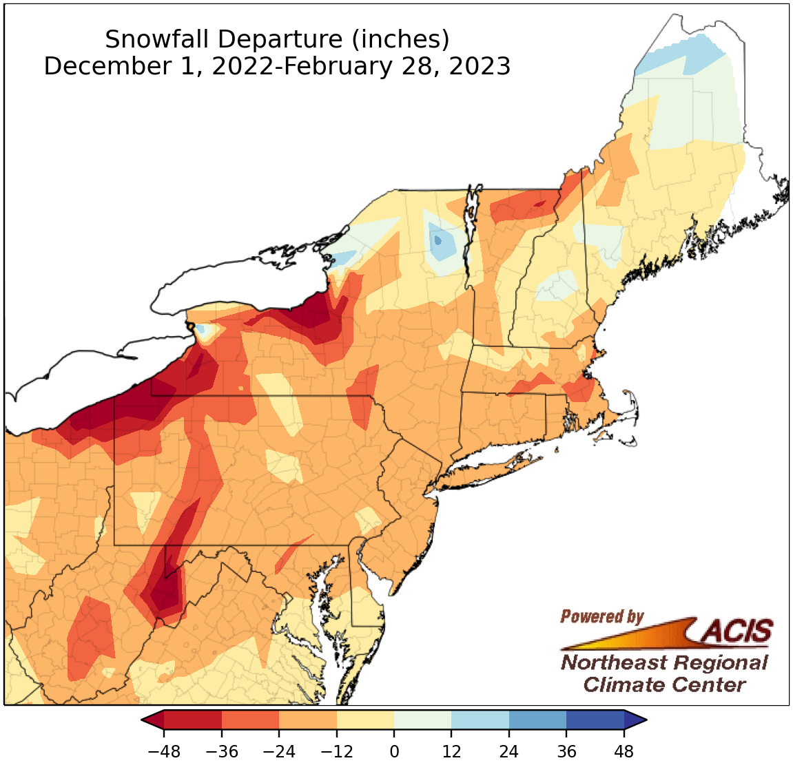
Winter snowfall ranged from more than 48 inches below normal to near normal for most of the Northeast, with localized areas of above-normal snowfall.
Most of the Northeast also saw snowfall deficits for the winter season, with the largest deficits of more than 48 inches in spots such as higher elevations of eastern West Virginia, northwestern Pennsylvania, and central New York. However, a few areas such as northern Maine and a sliver of western New York (due to a major lake-effect event) had snowfall surpluses of up to 24 inches. This winter was the least snowy on record for Baltimore, MD, and Atlantic City, NJ, and ranked among the 20 least snowy for another 27 of the 35 major climate sites. On the other hand, Caribou, ME, and Buffalo, NY, the only two sites to be snowier than normal, experienced one of their 20 snowiest winters on record. Overall, winter snowfall at the major climate sites ranged from 58.2 inches below normal in Erie, PA, to 16.6 inches above normal in Buffalo, NY.
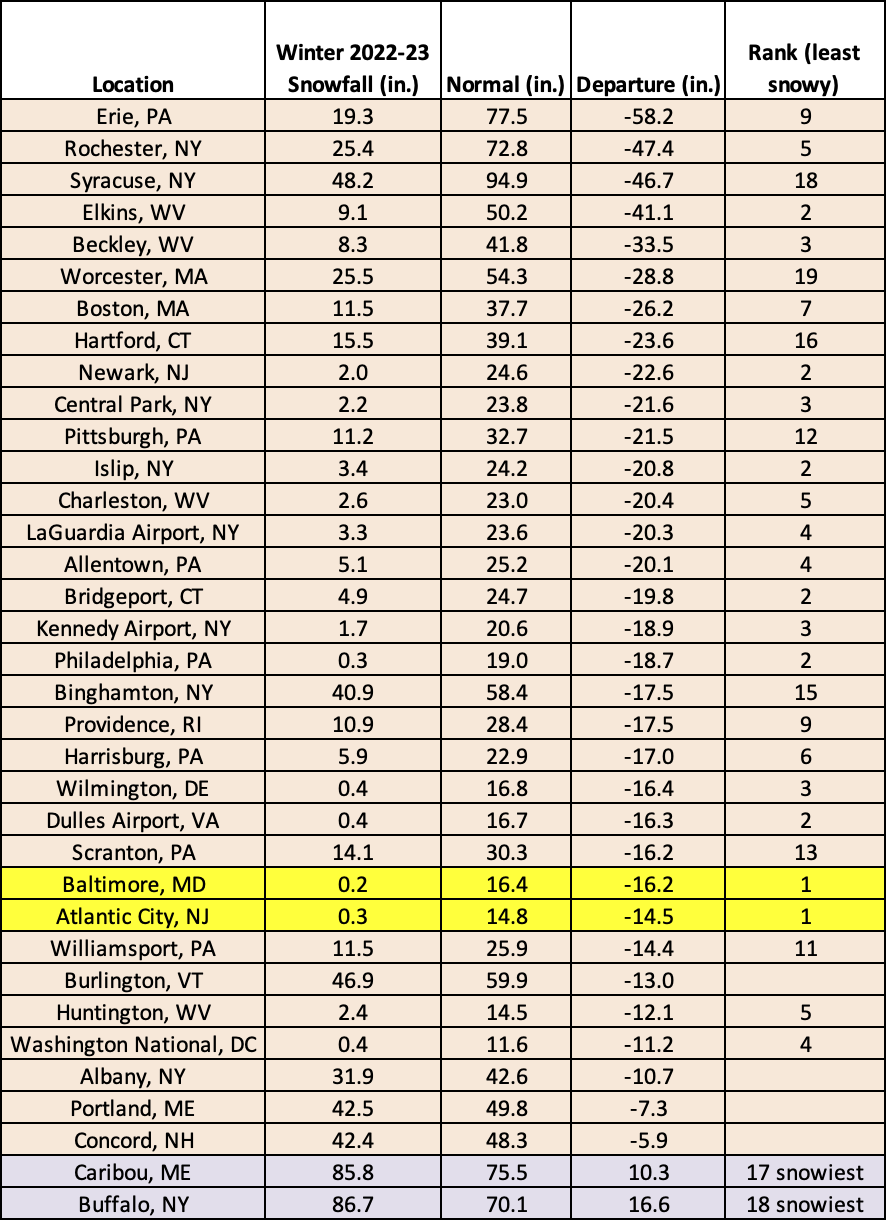
This winter was the least snowy on record for Baltimore, MD, and Atlantic City, NJ, and among the 20 least snowy for another 27 major climate sites. However, Caribou, ME, and Buffalo, NY, had one of their 20 snowiest winters on record.
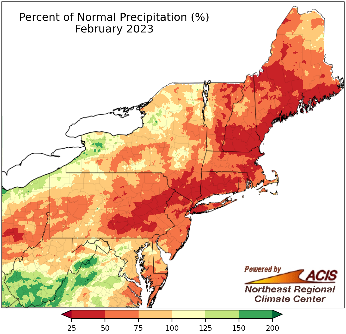
February precipitation ranged from 25% of normal to near normal for a large portion of the Northeast.
Much of the Northeast wrapped up February on the dry side of normal, with the driest locations in an area from eastern Pennsylvania into New England seeing 25% to 50% of normal precipitation. However, a few spots were wetter, including southern West Virginia and western New York, which saw up to 200% of normal precipitation. Twenty-seven of the 35 major climate sites were drier than normal in February, with precipitation for all sites ranging from 36% of normal in Harrisburg, PA, to 152% of normal in Beckley, WV. This February ranked among the 20 driest on record for 18 of the sites but was Beckley’s 16th wettest.
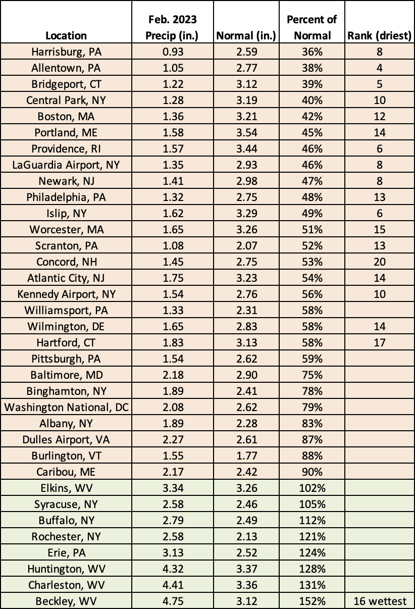
This February ranked among the 20 driest on record for 18 major climate sites but was the 16th wettest for Beckley, WV.
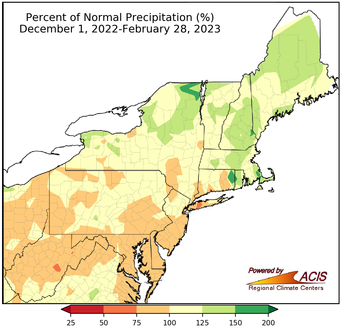
Winter precipitation ranged from 75% of normal to 150% of normal.
Precipitation amounts varied during each of the three winter months, so overall winter precipitation ranged from 75% of normal to 150% of normal, with southern areas tending to be drier and northern areas tending to be wetter. The 35 major climate sites were nearly split, with 16 being drier than normal, one landing at normal, and 18 being wetter than normal. Winter precipitation at the sites ranged from 85% of normal in Washington, D.C., to 138% of normal in Buffalo, NY, with six sites having one of their 20 wettest winters on record.
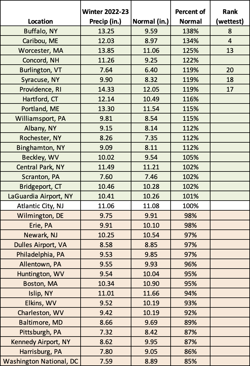
This winter ranked among the 20 wettest on record for six major climate sites.
Conditions could take a turn during March, according to NOAA’s Climate Prediction Center. The precipitation outlook shows a slightly increased chance of above-normal precipitation for portions of West Virginia, western Maryland, and southwestern Pennsylvania, with equal chances of below-, near-, or above-normal precipitation for the rest of the Northeast. Notably, the March temperature outlook favors below-normal temperatures for most of the Northeast, except southern West Virginia, with the highest chance in parts of New York and New England.
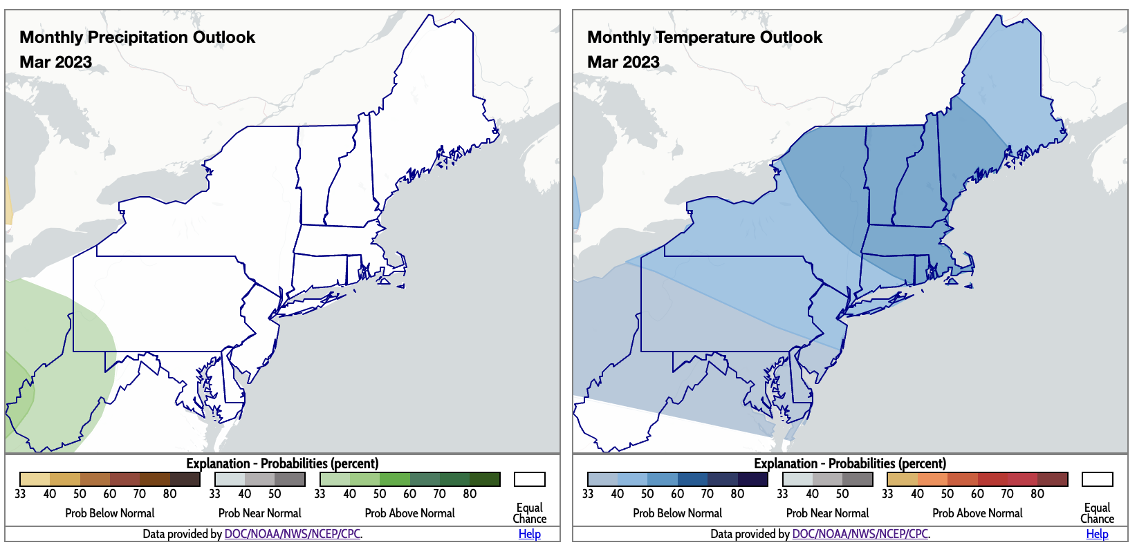
For March, there’s an increased likelihood of above-normal precipitation in the southwestern corner of the region and increased chances of below-normal temperatures for most of the region. Click to enlarge.