Stuck on Repeat
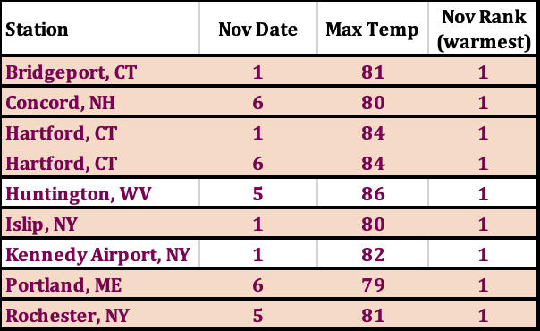
Several sites had their warmest high temperature for November.
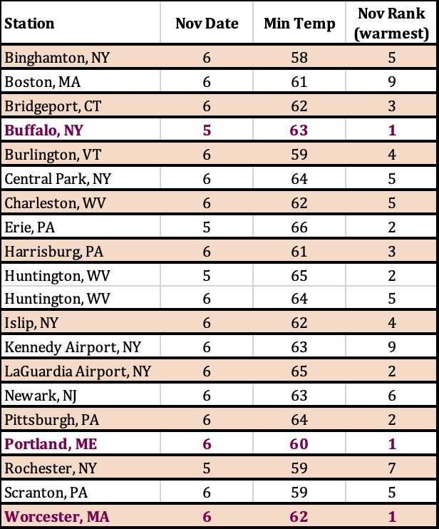
The first week of November featured record or near-record warm temperatures. Eight major climate sites saw their warmest high temperatures for November, while many other sites had one of their 10 warmest, in some cases, for multiple days. For instance, Bridgeport, CT, had its record, seventh, and 10th warmest high temperatures for November in just the first week of this month! Low temperatures were also notable, being record warm for November at three sites and ranking among the 10 warmest at several other sites.
Three sites saw their warmest low temperature for November (bold pink) and a few others had one of their 10 warmest.
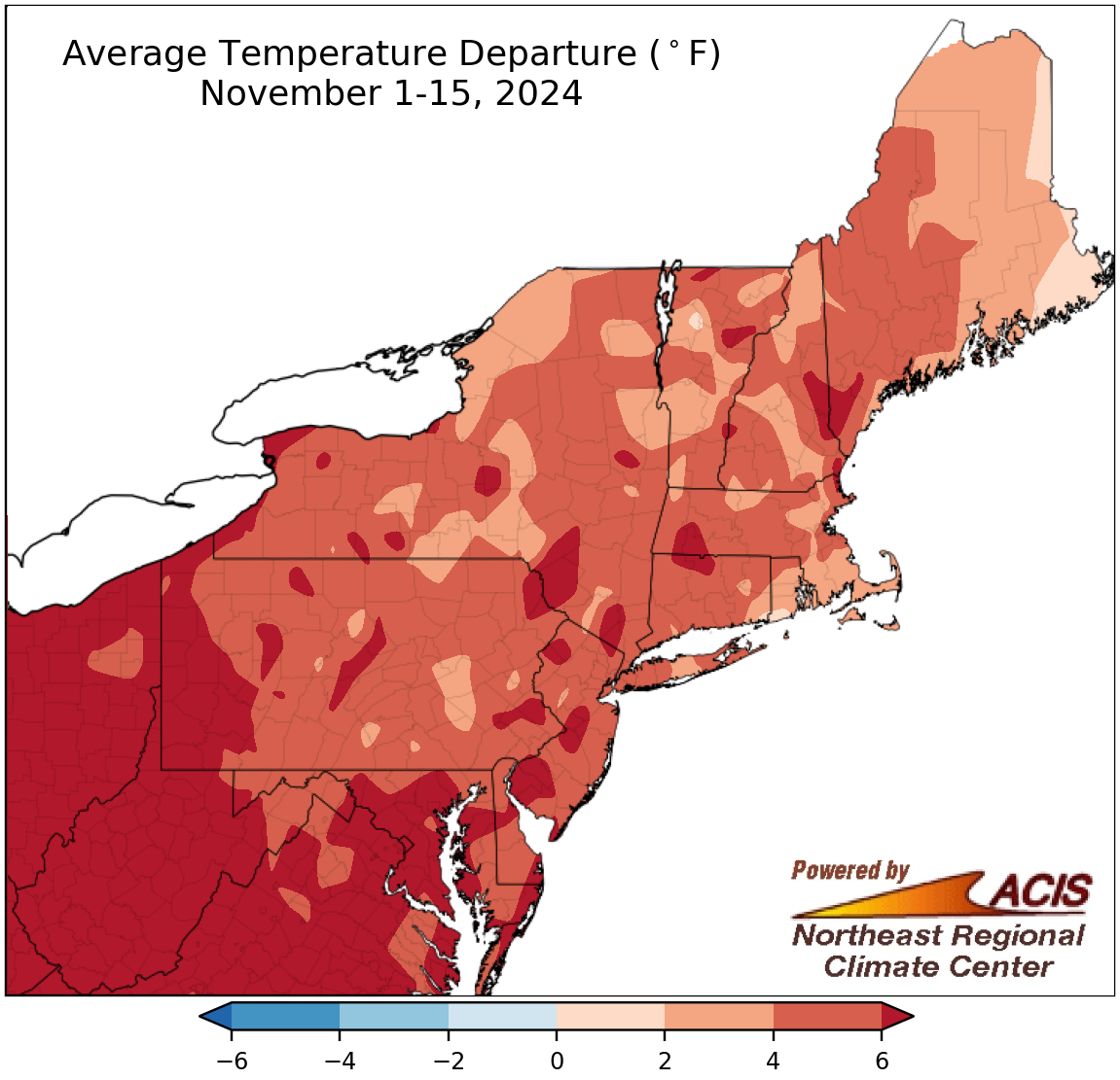
November 1-15 average temperatures ranged from near normal to more than 6°F above normal.
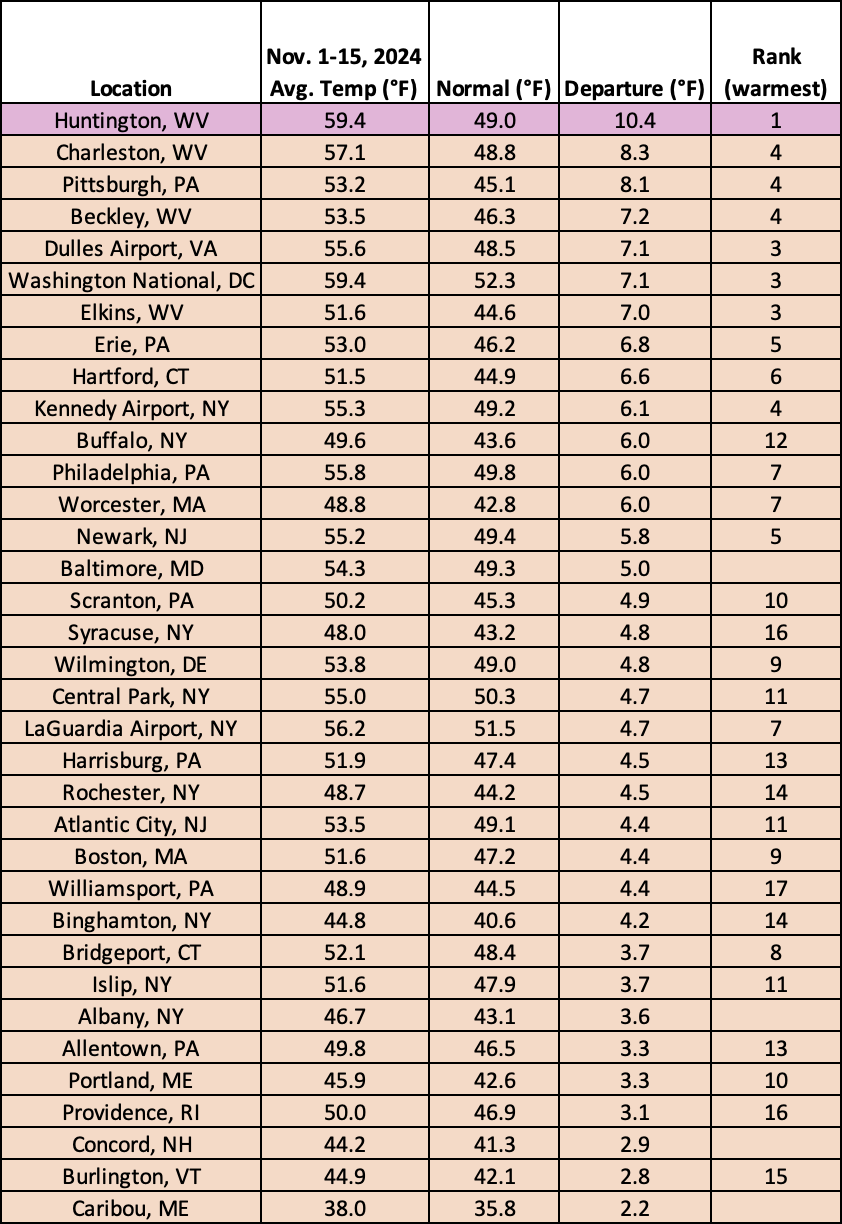
This early month warmth helped the entire November 1-15 period to be warmer than normal for the entire Northeast, with the greatest departures above normal topping 6°F. Average temperatures for the first half of November at the region’s 35 major climate sites ranged from 2.2°F above normal in Caribou, ME, to 10.4°F above normal in Huntington, WV. In fact, Huntington had its warmest November 1-15 period on record, which also ranked among the 20 warmest for another 30 major climate sites.
The November 1-15 period was record warm for Huntington, WV, and among the 20 warmest for another 30 major climate sites.
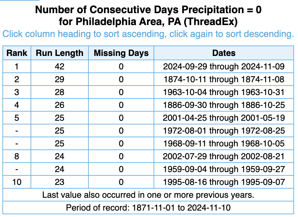
The record long streak of consecutive days without measurable precipitation ended in Philadelphia, PA, after 42 days (September 29-November 9), or six weeks, with records back to 1871.
After more than five weeks, the record long streak of consecutive days without measurable precipitation (0.01 inches or greater) finally ended at multiple major climate sites on November 10. Both Philadelphia, PA, and Wilmington, DE, went 42 days (September 29-November 9), or six weeks, without measurable precipitation, blasting past their old records of 29 days and 34 days, respectively. Records extend back to 1871 in Philadelphia and 1894 in Wilmington. Newark, NJ’s record ended after 41 days (September 30-November 9), while the streaks at Atlantic City, NJ; Baltimore, MD; Washington, D.C.; and Dulles Airport, VA, ended after 38 days (October 3-November 9).
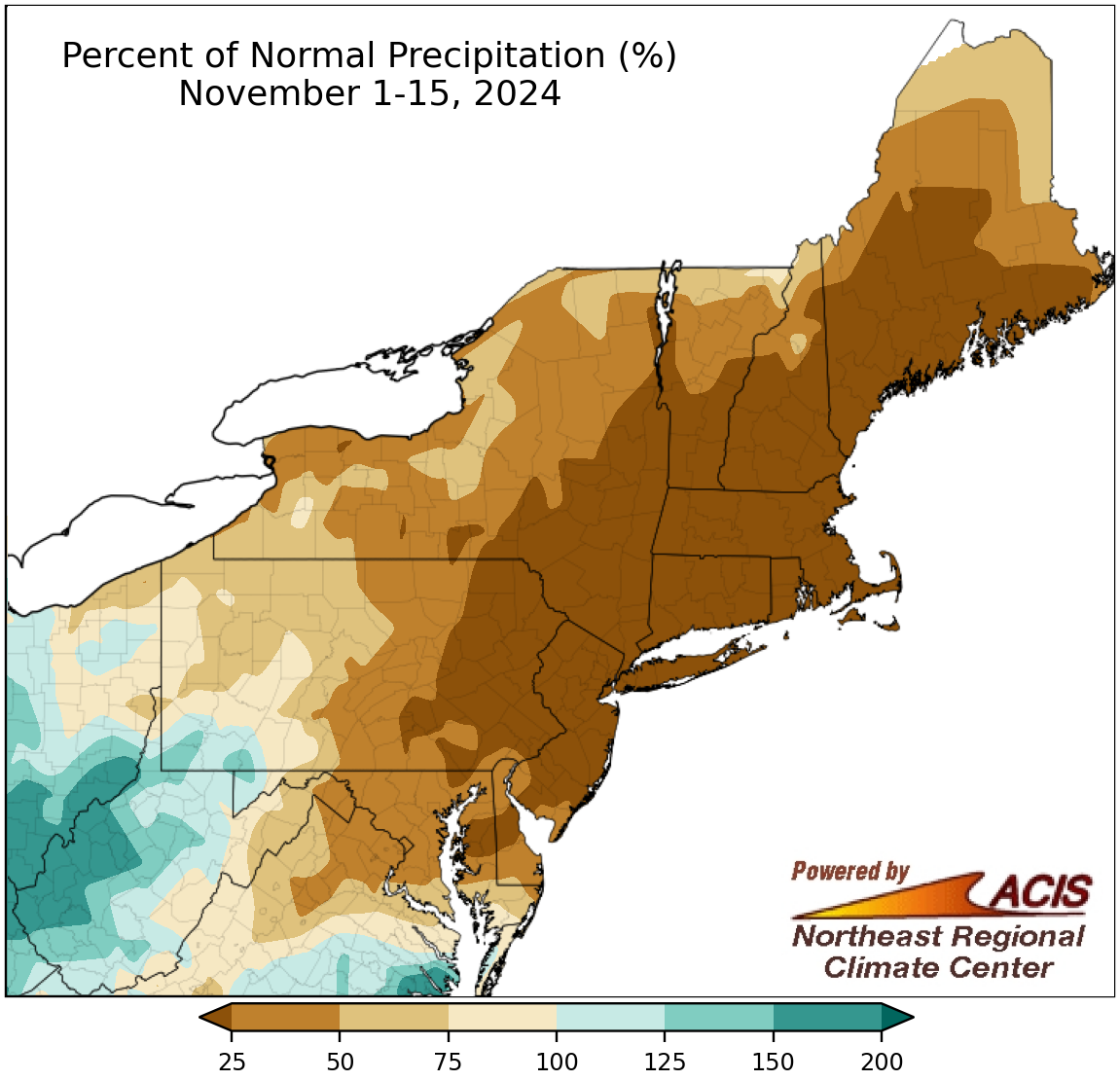
November 1-15 precipitation ranged from less than 25% of normal to 200% of normal.
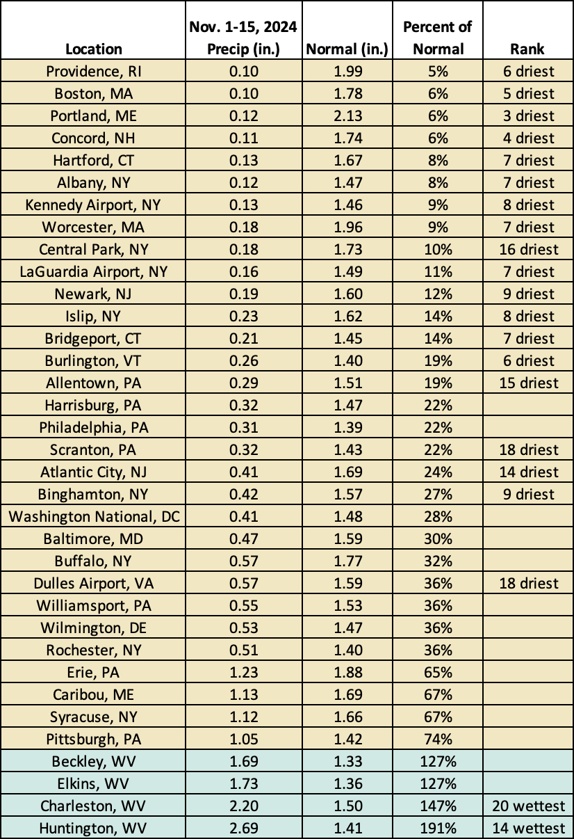
Even though measurable rain finally fell, most areas generally saw light amounts. In fact, much of the Northeast was drier than normal during the first half of November, with an area from Maryland to Maine seeing less than 25% of normal precipitation. Over the past two months, this area has seen rapid intensification of drought conditions, and corresponding impacts such as an unusually high number of wildfires, reduced water levels and mandatory water restrictions, and impacts to fall planting. You can read more about drought conditions and impacts in the Northeast in the NRCC’s weekly drought update. Overall, 31 of the Northeast’s 35 major climate sites were drier than normal, with 19 of them ranking this November 1-15 period among their 20 driest on record. The driest location, Providence, RI, saw only 5% of normal precipitation.
On the other hand, portions of West Virginia and southwestern Pennsylvania saw up to 200% of normal precipitation. The four West Virginia sites were the only major climate sites to be wetter than normal, with Huntington having its 14th wettest start to November with 191% of normal and Charleston having its 20th wettest at 147% of normal. The rain was much-needed and chipped away at exceptional and extreme drought conditions in some areas.
This first half of November ranked among the 20 driest for 19 major climate sites but was among the 20 wettest for two others.
Climatological normals show that many parts of the Northeast average measurable snow during the first half of November including 29 of the region’s 35 major climate sites. However, it’s not uncommon to see no snow during the period. Caribou, ME, was the only major climate site to see measurable snow this first half of November, which was just a bit late as the average date for first measurable snow ranges from October 28 in Caribou to December 23 in Atlantic City, NJ. Meanwhile, the average date of first inch of snow ranges from November 7 in Caribou to January 3 in Washington, D.C.
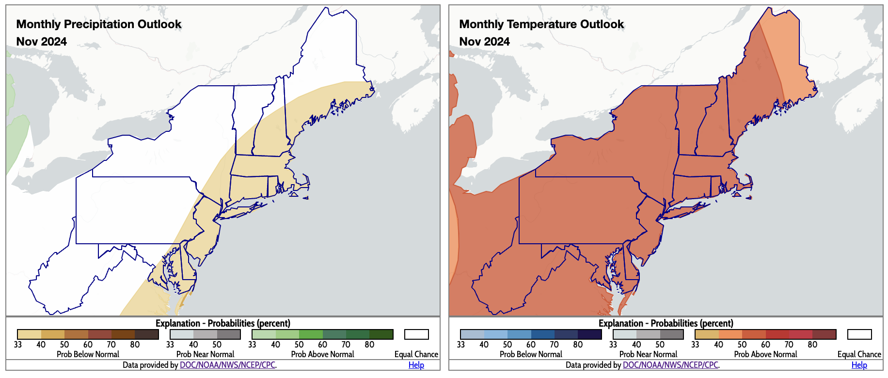
For November, below-normal precipitation is favored for coastal areas (shaded tan), while above-normal temperatures are predicted for the entire Northeast (shaded orange). Click to enlarge.
The November outlook from NOAA’s Climate Prediction Center favors drier-than-normal conditions for coastal areas from Maryland to Maine, with equal chances of below-, near-, or above-normal precipitation for the rest of the Northeast. The entire region is expected to average out to be warmer than normal for the month. Outlooks for December and winter will be released by the Climate Prediction Center on November 21.

