Spring - Plenty of Warmth and Little Snow
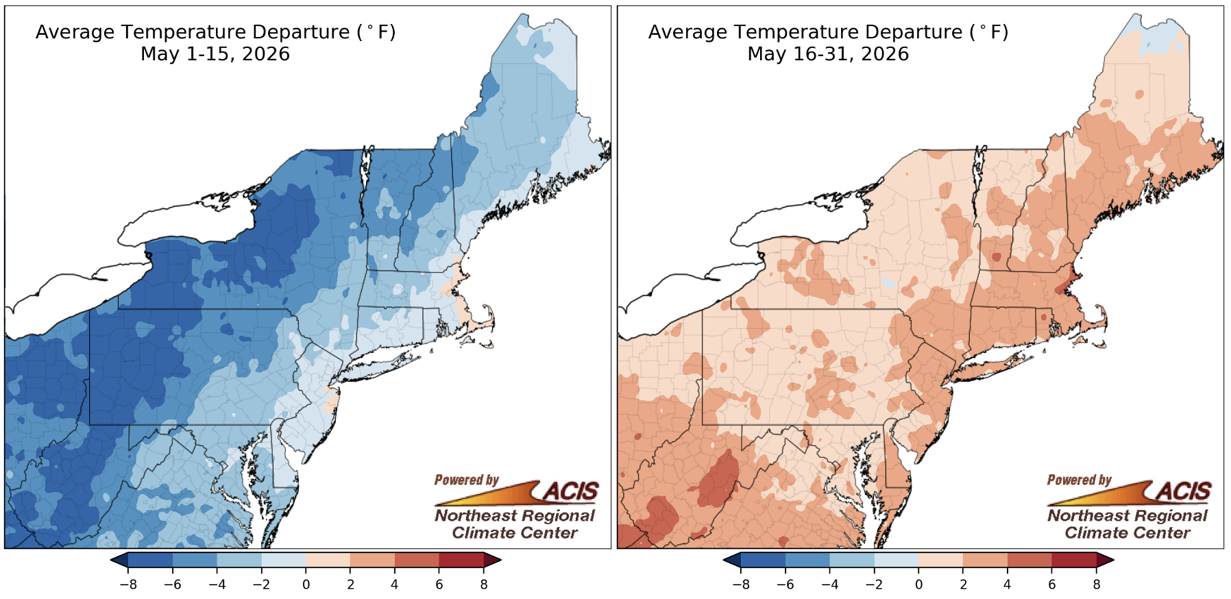
May 1-15 average temperatures were as much as 8°F below normal, but May 16-31 temperatures were up to 6°F above normal. Click to enlarge.
The first half of May featured average temperatures that were as much as 8°F cooler than normal, but the second half was up to 6°F warmer than normal. This warmth was driven by a heat event from May 18 to 20 that -
- set or tied the hottest May temperature on record in Newark, NJ, and Philadelphia, PA
- gave Binghamton, NY, its warmest low temperature for May
- generated a high of 90°F in Erie, PA, tying its record for May and spring
- produced near record warmth in multiple locations across the region
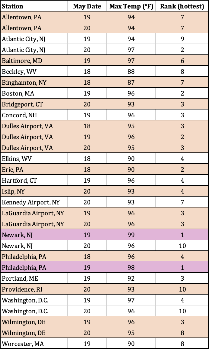
High temperatures during a heat event from May 18 to 20 were record hot for May in Newark, NJ, and Philadelphia, PA, and among the 10 hottest for multiple other sites.
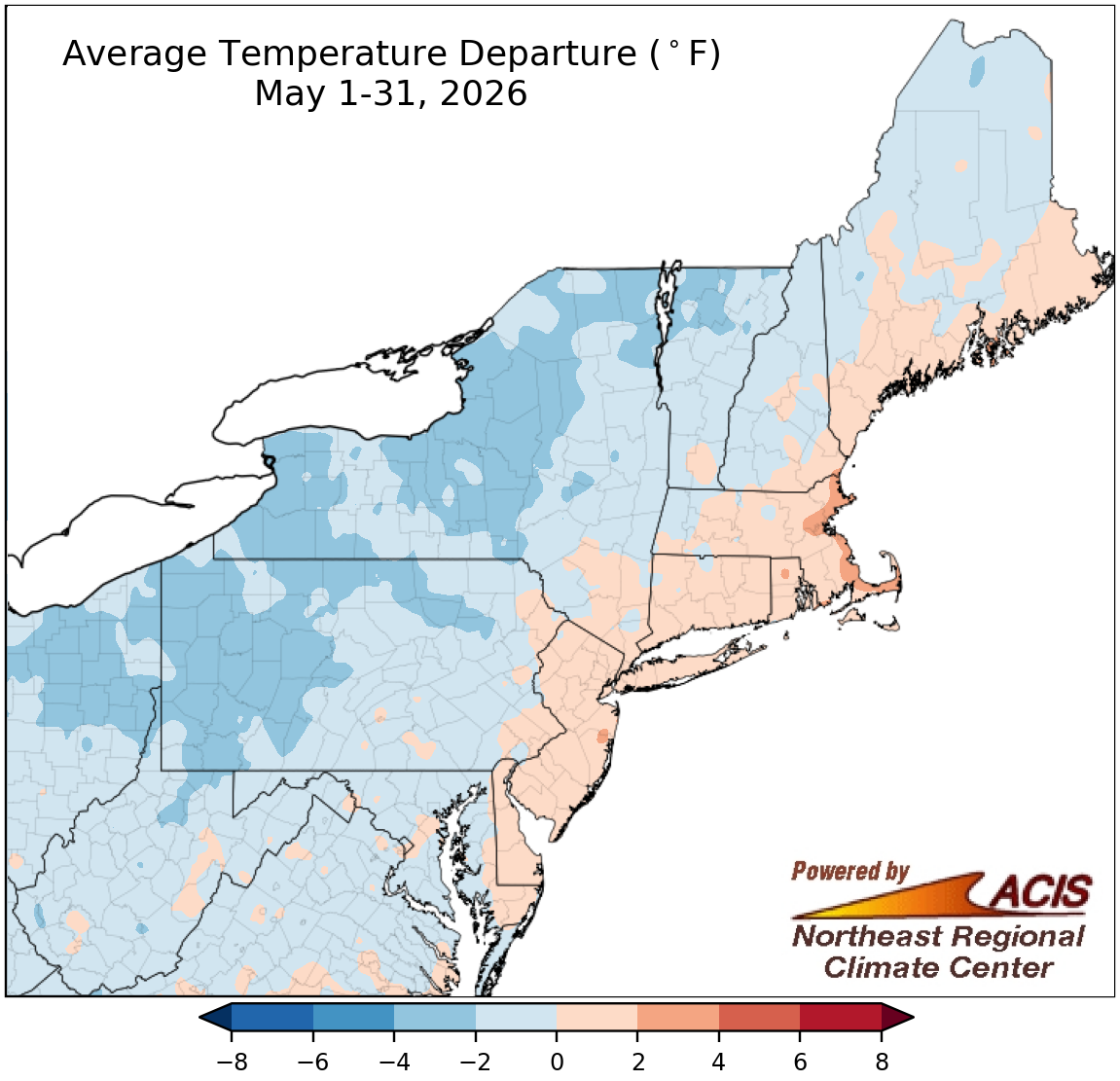
May average temperatures ranged from 4°F cooler than normal to 4°F warmer than normal.
For most areas, the later-month warmth was not enough to overcome the cool temperatures earlier in the month, with a large portion of the Northeast wrapping up May on the cool side of normal. However, warmer temperatures prevailed in some coastal locations. Overall, average temperatures for the month ranged from as much as 4°F below normal along a path from northern West Virginia to northern Vermont up to 4°F above normal in eastern Massachusetts. May average temperatures at the Northeast’s 35 major sites ranged from 2.9°F below normal in Rochester, NY, and Scranton, PA, to 2.4°F above normal in Boston, MA. This May was the 17th warmest on record for Portland, ME, and the 20th warmest for Boston.
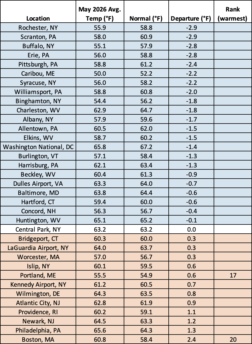
This May ranked among the 20 warmest Mays for two major sites.
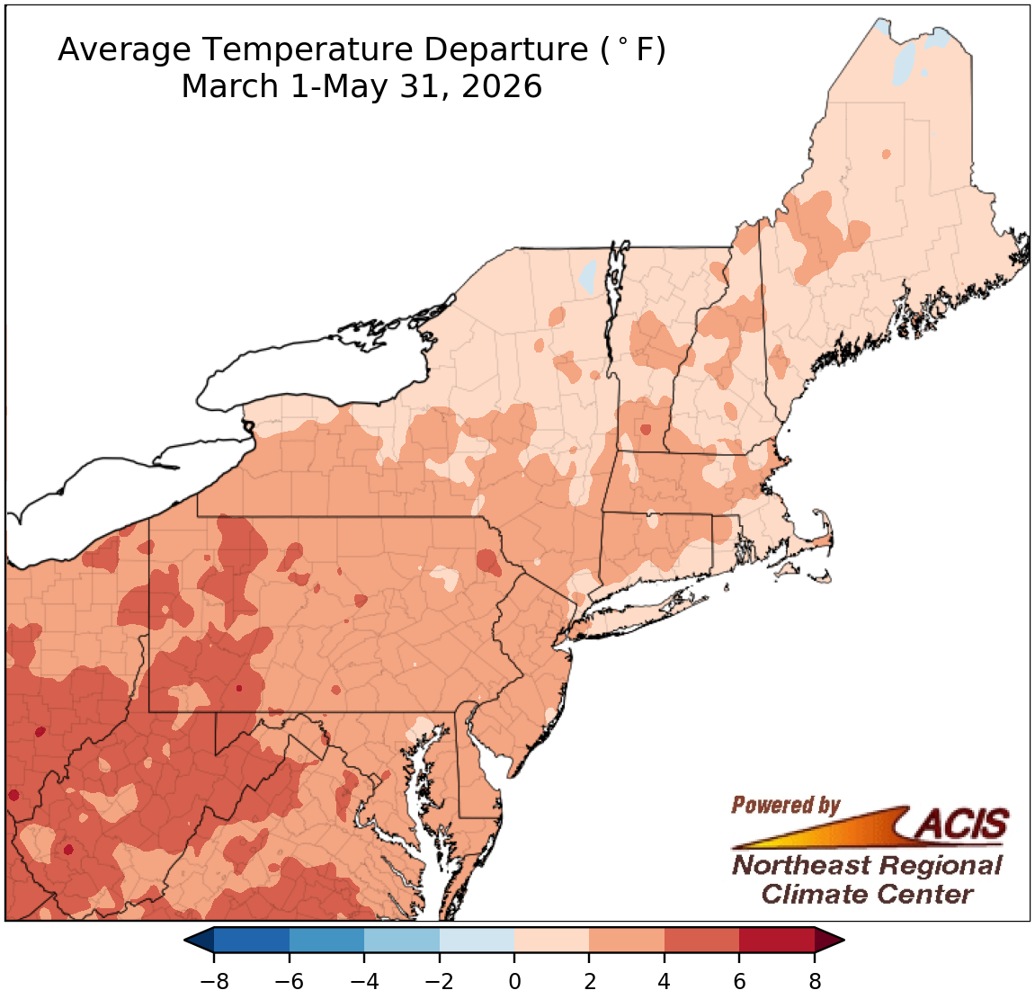
Spring average temperatures were as much as 6°F warmer than normal.
Driven by unusually warm temperatures in March and April, the spring season was warmer than normal for almost the entire Northeast. The greatest departures above normal were in locations like western Pennsylvania, western Maryland, and much of West Virginia, which were as much as 6°F warmer than normal. In fact, spring 2026 was the warmest spring on record for Huntington and Elkins, WV, and ranked among the 20 warmest springs for another 29 of the region’s 35 major sites. Overall, average temperatures for spring at all 35 sites ranged from 0.6°F below normal in Caribou, ME, the only cooler-than-normal site, to 5.5°F above normal in Huntington. In addition, Hartford, CT, saw five days this spring with a high of at least 90°F, tying its record for the season.
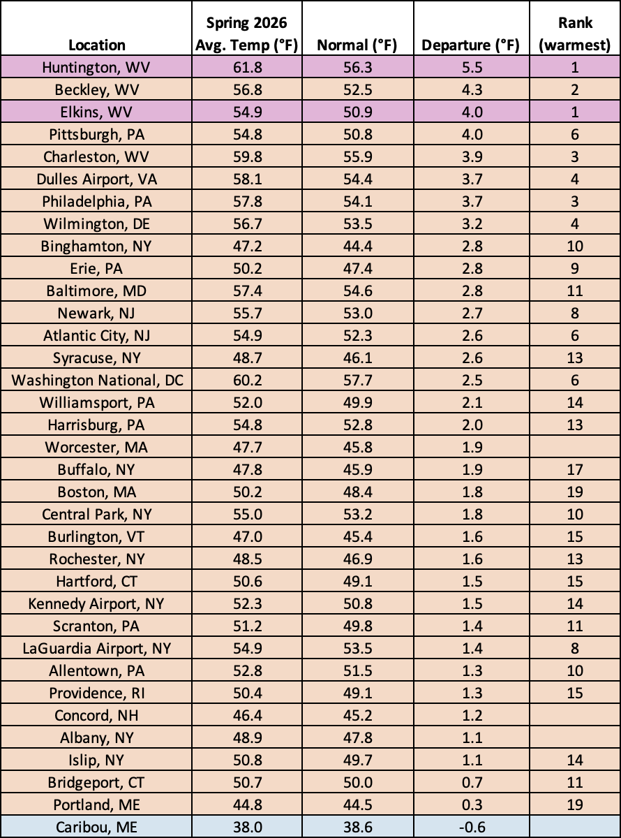
This spring was record warm for Huntington and Elkins, WV, and ranked among the 20 warmest springs for another 29 major sites.
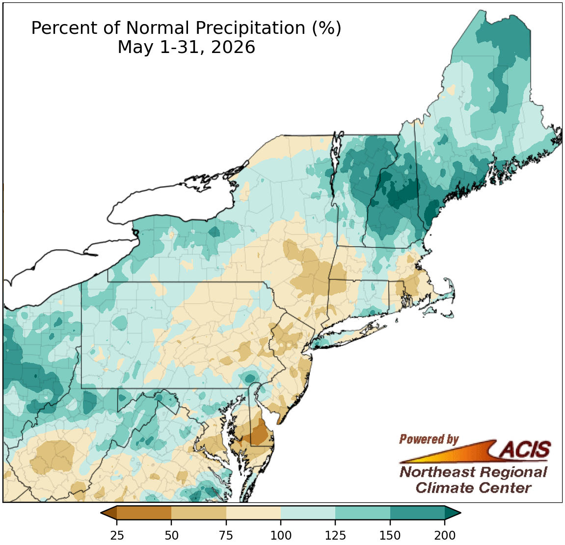
May precipitation ranged from less than 50% of normal to more than 200% of normal.
The two halves of May featured different precipitation patterns, particularly for southern parts of the region and much of Maine. For example, the first half of May was drier than normal for southern areas but very wet in Maine, while the second half of May brought heavy precipitation to some southern areas but drier conditions to much of Maine.
For the full month, precipitation ranged from less than 50% of normal on the Delmarva Peninsula to more than 200% of normal in parts of northern New England. May precipitation at the Northeast’s 35 major sites ranged from 49% of normal in Atlantic City, NJ, to 191% of normal in Portland, ME, with 21 of the sites being drier than normal. This May ranked among the 20 driest Mays for two major sites but among the 20 wettest for three others. Drought and abnormal dryness initially expanded in the Mid-Atlantic but improved in spots that received notable rainfall during the second half of the month. Improvements also were noted in northern New England, but there was some deterioration in southern New England and southeastern New York.
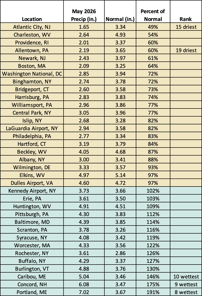
This May was among the 20 driest Mays for two major sites but among the 20 wettest for three others.
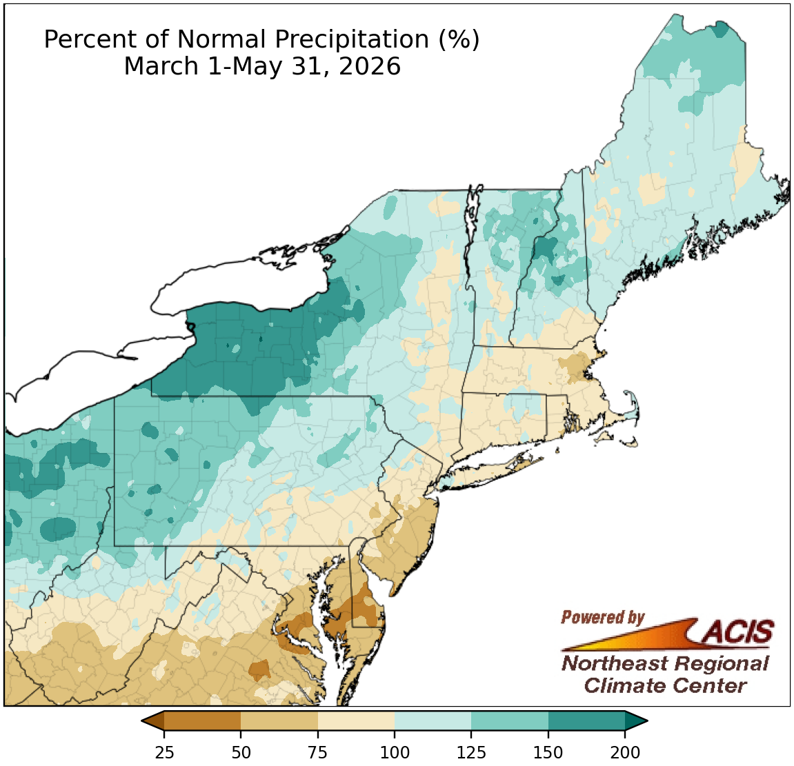
Spring precipitation ranged from less than 50% of normal to 200% of normal.
Precipitation during spring ranged from less than 50% of normal in the region’s southeastern corner to over 150% of normal in places like western and central New York. Spring precipitation at the region’s 35 major sites ranged from 54% of normal in Atlantic City, NJ, to 168% of normal in Buffalo, NY, with 22 sites being drier than normal. Spring 2026 ranked among the 20 driest springs for six major sites but among the 20 wettest for eight others.
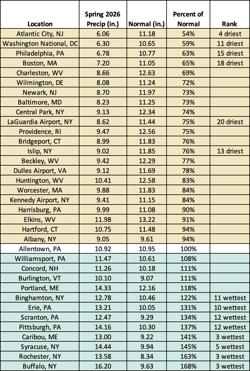
This spring ranked among the 20 driest springs for six major sites but among the 20 wettest for eight others.
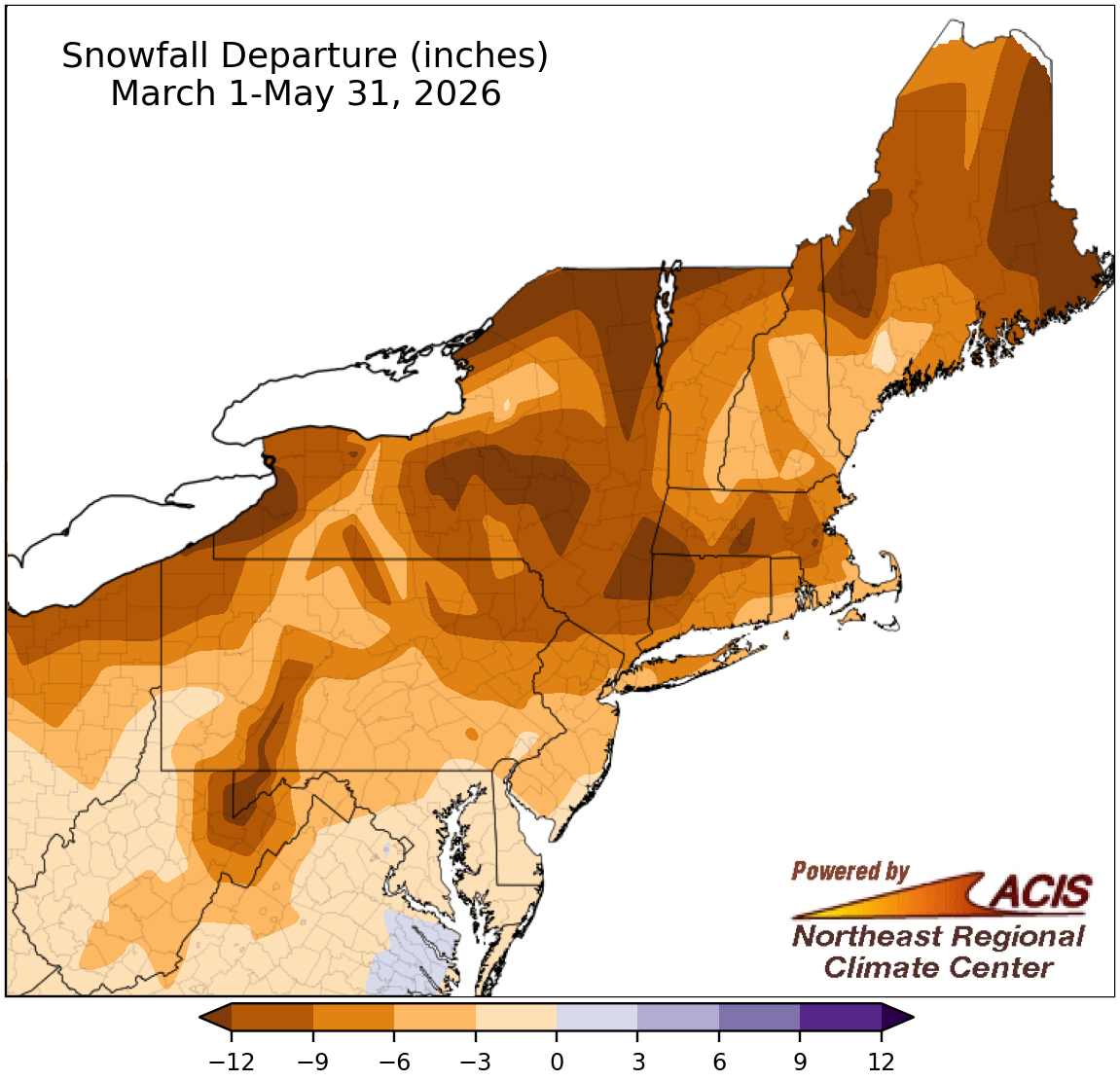
Spring snowfall ranged from over 12 inches below normal to near normal.
The entire Northeast had a snowfall deficit this spring, with the largest deficits of over 12 inches found throughout the region. Spring snowfall at the 35 major sites ranged from 14.5 inches below normal in Rochester, NY, to 0.8 inches below normal in Charleston, WV, and Baltimore, MD. Looking at the 25 major sites that saw measurable snowfall, this spring ranked among the 20 least snowy springs for eight of them.
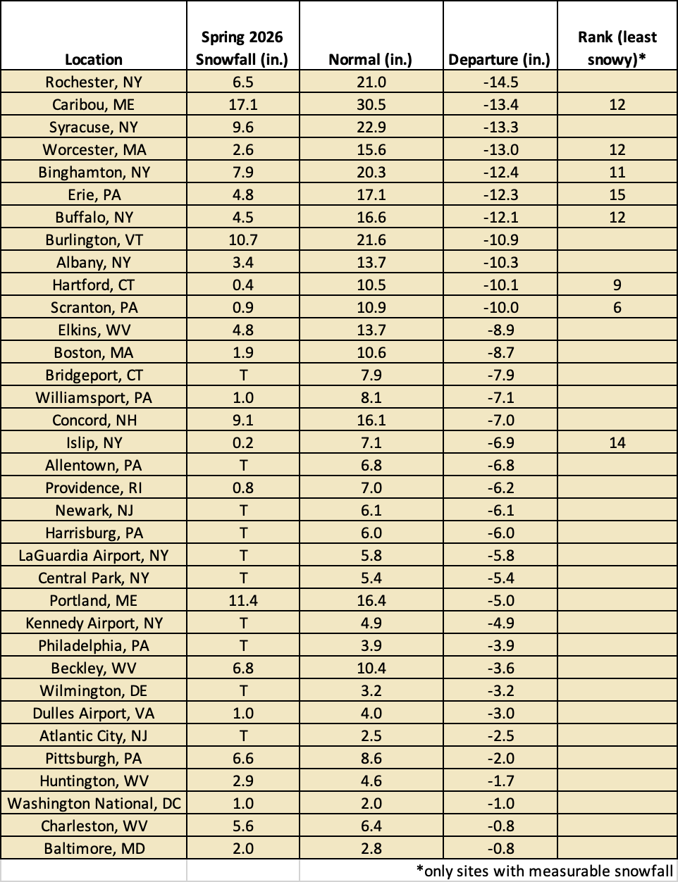
This spring ranked among the 20 least snowy springs at eight major sites that saw measurable snowfall.
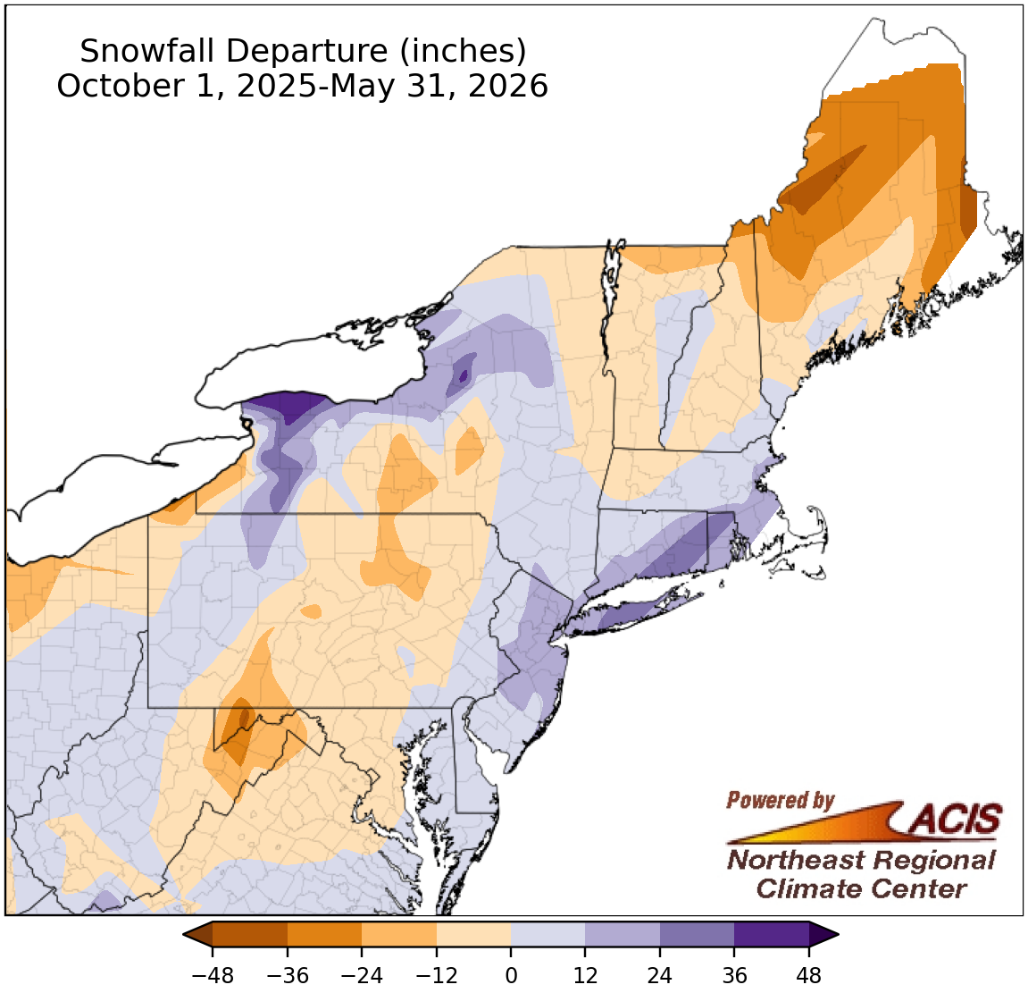
October-May snowfall ranged from over 24 inches below normal to over 36 inches above normal.
Snowfall during the full snow season (October through May) ranged from over 24 inches below normal in places like Maine to over 36 inches above normal in places like western New York. At the region’s 35 major sites, seasonal snowfall ranged from 31.7 inches below normal in Caribou, ME, to 32.7 inches above normal in Providence, RI, with 18 of the sites being snowier than normal. This snow season ranked among the 20 least snowy for two major sites but was among the 20 snowiest for seven others.

The October-May snow season ranked among the 20 least snowy for two major sites but among the 20 snowiest for seven others.
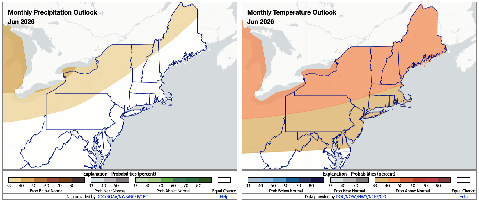
June is expected to be drier (shaded tan) and warmer (shaded orange) than normal for several areas. Click to enlarge.
For June, outlooks from NOAA’s Climate Prediction Center (CPC) show an increased chance of drier-than-normal conditions for an area from northwestern Pennsylvania to northern Maine. Equal chances of below-, near-, or above-normal precipitation were forecast for the rest of the Northeast. Most of the region is expected to average out to be warmer than normal, with a greater likelihood in northern Pennsylvania, much of New York, parts of Massachusetts, and northern New England. However, southern West Virginia, parts of southern and eastern Maryland, and southern Delaware fall into the equal chances category.
For summer, CPC predicts wetter-than-normal weather for New England, New Jersey, much of New York, eastern Pennsylvania, and parts of Maryland and Delaware, with equal chances elsewhere in the region. Most of the Northeast is expected to be warmer than normal, except a portion of western New York, northwestern Pennsylvania, and a sliver of northern West Virginia where equal chances were forecast. Additionally, the Atlantic hurricane season is expected to be less active than usual.
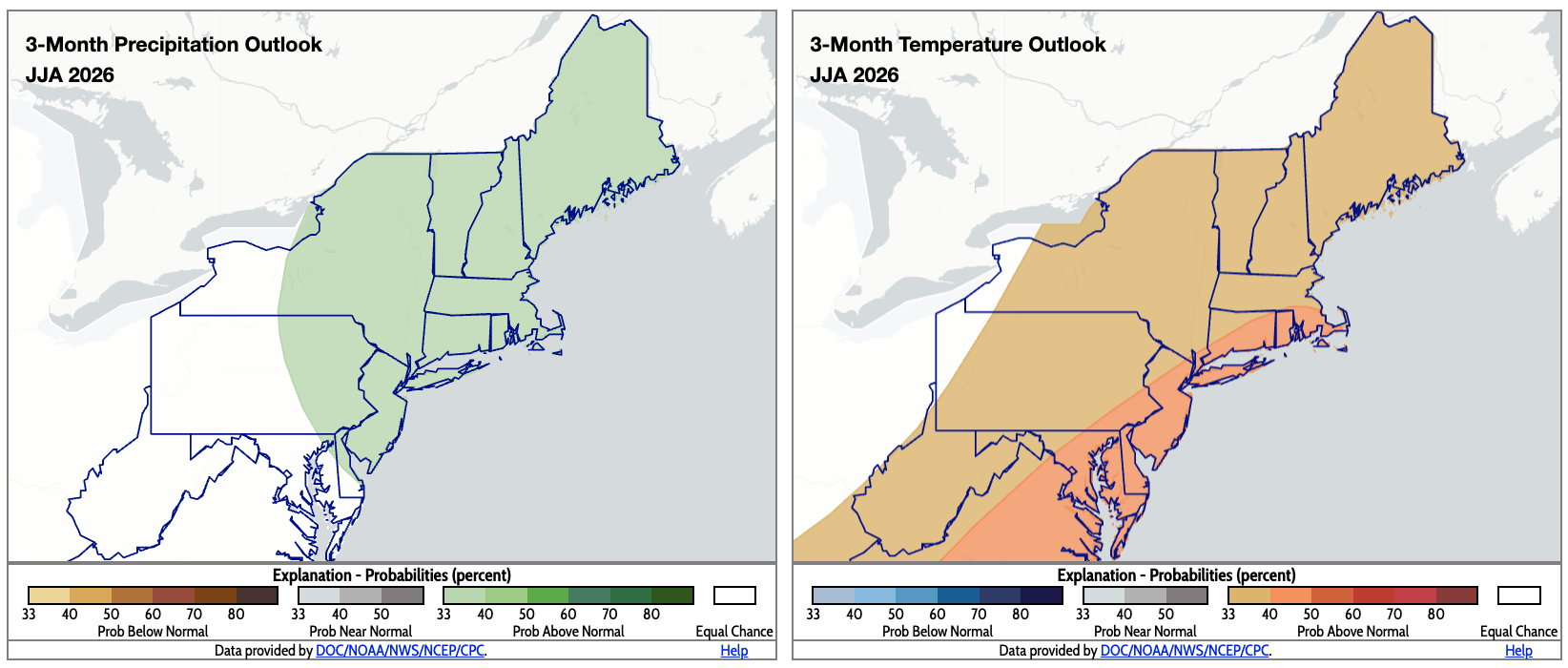
CPC’s summer outlooks indicate a tilt toward wetter-than-normal conditions for several areas (shaded green) and warmer-than-normal temperatures for most of the Northeast (shaded orange). Click to enlarge.